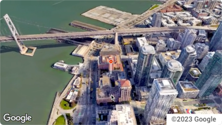
Aerial View API는 미국 내 모든 실제 주소의 실사 3D 항공 동영상을 만들고 표시할 수 있는 서비스입니다. 이 동영상은 상공에서 선회하는 드론이 촬영한 영상을 시뮬레이션합니다.
Google에서 이미 사전 렌더링된 항공 뷰 동영상 데이터 세트를 만들어 두었으므로 이를 사용하면 됩니다. 미국 전역의 대형 건물과 명소를 다룹니다.
항공 뷰 동영상도 계속 추가되고 있습니다. 이러한 기존 동영상을 사용하거나 주소에 대한 동영상이 아직 없는 경우 Google에 새 동영상을 생성해 달라고 요청할 수 있습니다.
Aerial View API를 사용해야 하는 이유
Aerial View API를 사용해야 하는 몇 가지 이유는 다음과 같습니다.
3D 데이터를 탐색하고 싶지만 3D 타일 사용이나 렌더러 작업에 익숙하지 않음
위성 이미지의 맥락과 스트리트 뷰에서 건물 외관을 인식하는 기능을 선호합니다.
부동산을 촬영하기 위해 드론 조종사를 고용하는 것을 고려한 적이 있습니다.
최첨단 혁신 기술을 사용하고 싶습니다.
웹사이트에 동영상을 삽입하는 데 문제가 없습니다.
Aerial View API로 할 수 있는 작업
다음은 Aerial View API로 할 수 있는 작업의 목록입니다.
근처 도로, 공원 또는 수역을 강조 표시하여 건물의 조감도 인식 제공
잠재적 임차인 또는 주택 구매자에게 부동산의 모습을 보여주세요
시청자에게 내 위치를 보여주는 Shorts 동영상으로 장면 설정
사용자가 휴가를 계획할 때 관광 명소 또는 관심 장소 강조 표시
배송 기사 또는 쇼핑객이 내 비즈니스를 찾을 수 있도록 지원
Aerial View API 작동 방식
Aerial View API를 사용하는 방법에는 두 가지가 있습니다.
접근 방식
근거
생성된 동영상 조회
필요한 모든 항공 이미지는 이미 Google에서 렌더링했습니다 (Google의 사전 렌더링 데이터 세트).
새 동영상 생성
Google에서 아직 사전 렌더링하지 않은 항공 뷰 이미지가 필요합니다.
서비스 지역
Aerial View API는 Google에서 3D 동영상을 렌더링할 수 있는 미국의 우편 주소만 지원합니다.
[null,null,["최종 업데이트: 2025-08-31(UTC)"],[[["\u003cp\u003eThe Aerial View API lets you create and display photorealistic 3D aerial videos of US addresses, simulating drone footage.\u003c/p\u003e\n"],["\u003cp\u003eGoogle provides a pre-rendered video dataset for many locations, or you can request new videos to be generated.\u003c/p\u003e\n"],["\u003cp\u003eUse the API to enhance user experiences with interactive 3D aerial views for various applications, such as real estate, travel planning, and business listings.\u003c/p\u003e\n"],["\u003cp\u003eAccess and display videos through the API, but note that downloading or storing them locally is not permitted.\u003c/p\u003e\n"],["\u003cp\u003eThe API is limited to US addresses where 3D video rendering is supported by Google.\u003c/p\u003e\n"]]],[],null,["The Aerial View API is a service that lets you create and display\nphotorealistic 3D aerial videos of any physical address within the United\nStates. The videos simulate footage taken by a drone circling overhead.\n\nGoogle has already created a dataset of pre-rendered aerial view videos for you\nto use. They cover large buildings and landmarks throughout the United States.\nAnd we're adding more aerial view videos all the time. You can simply use these\nexisting videos or, if a video does not yet exist for an address, you can\nrequest that Google generate a new one for you.\n| **Note:** Google automatically pre-renders videos for addresses periodically, so some addresses will have no wait time.\n\nWhy use Aerial View API\n\nHere are some reasons why you might want to use Aerial View API.\n\n- You want to explore 3D data, but you're not comfortable using 3D Tiles, or with working with a renderer\n\n- You like the context of satellite imagery, and the ability to recognize a building facade from Street View\n\n- You've considered hiring a drone operator to film your property\n\n- You want to use cutting-edge, innovative technology\n\n- You're comfortable embedding video in your web site\n\nWhat you can do with Aerial View API\n\nHere's a list of some of the things you can do with Aerial View API.\n\n- Provide birds-eye awareness of a building by highlighting nearby roads, parks, or bodies of water\n\n- Give a prospective renter or home buyer a sense of what a property is like\n\n- Set the scene for a short-form video showing the viewer where you are\n\n- Highlight attractions or points-of-interest when helping users plan a vacation\n\n- Help delivery drivers or shoppers find your place of business\n\nHow the Aerial View API works\n\nThere are two approaches that you can take to use the Aerial View API.\n| **Tip:** Both of these approaches should begin with you checking whether the video exists using the [`lookupVideoMetadata`](/maps/documentation/aerial-view/lookup-video-metadata) endpoint.\n\n| Approach | Rationale |\n|--------------------------|--------------------------------------------------------------------------------------------------------------|\n| Lookup a generated video | All of the aerial imagery that you need has already been rendered by Google (Google's pre-rendered dataset). |\n| Generate a new video | You need aerial view imagery that hasn't already been pre-rendered by Google. |\n\nCoverage areas\n\nAerial View API only supports postal addresses in the United States where\nGoogle is able to render 3D videos.\n\nHow to use the Aerial View API\n\n|---|------------------------------------------------------|----------------------------------------------------------------------------------------------------------------------------------------------------------------------------------------------------------------------|\n| 1 | **Review the Google Maps Platform Terms of Service** | Note that you cannot download, store, or cache the aerial view videos. For more information, see the [Google Maps Platform Terms of Service](https://cloud.google.com/maps-platform/terms/). |\n| 2 | **Get set up** | Start with [Set up your Google Cloud project](/maps/documentation/aerial-view/cloud-setup) and complete the instructions that follow. |\n| 3 | **Retrieve an aerial view video's metadata** | Send a US postal address or `videoId` to the `lookupVideoMetadata()` endpoint to return an aerial view video's metadata. See [Retrieve a video's metadata.](/maps/documentation/aerial-view/lookup-video-metadata) |\n| 4 | **Fetch an existing aerial view video** | Send a US postal address or `videoId` to the `lookupVideo()` endpoint to return a pre-rendered aerial view video. See [Fetch a generated video.](/maps/documentation/aerial-view/lookup-video) |\n| 5 | **Generate a new aerial view video** | Send a US postal address to the `renderVideo()` endpoint to request the generation of a new aerial view video for the specified address. See [Generate a new video.](/maps/documentation/aerial-view/generate-video) |"]]