Stay organized with collections
Save and categorize content based on your preferences.
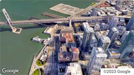
The Aerial View API is a service that lets you create and display
photorealistic 3D aerial videos of any physical address within the United
States. The videos simulate footage taken by a drone circling overhead.
Google has already created a dataset of pre-rendered aerial view videos for you
to use. They cover large buildings and landmarks throughout the United States.
And we're adding more aerial view videos all the time. You can simply use these
existing videos or, if a video does not yet exist for an address, you can
request that Google generate a new one for you.
Why use Aerial View API
Here are some reasons why you might want to use Aerial View API.
You want to explore 3D data, but you're not comfortable using 3D Tiles, or with working with a renderer
You like the context of satellite imagery, and the ability to recognize a building facade from Street View
You've considered hiring a drone operator to film your property
You want to use cutting-edge, innovative technology
You're comfortable embedding video in your web site
What you can do with Aerial View API
Here's a list of some of the things you can do with Aerial View API.
Provide birds-eye awareness of a building by highlighting nearby roads, parks, or bodies of water
Give a prospective renter or home buyer a sense of what a property is like
Set the scene for a short-form video showing the viewer where you are
Highlight attractions or points-of-interest when helping users plan a vacation
Help delivery drivers or shoppers find your place of business
How the Aerial View API works
There are two approaches that you can take to use the Aerial View API.
Approach
Rationale
Lookup a generated video
All of the aerial imagery that you need has already been rendered by Google (Google's pre-rendered dataset).
Generate a new video
You need aerial view imagery that hasn't already been pre-rendered by Google.
Coverage areas
Aerial View API only supports postal addresses in the United States where
Google is able to render 3D videos.
Send a US postal address or videoId to the
lookupVideoMetadata() endpoint to return an aerial view
video's metadata.
See Retrieve a video's metadata.
4
Fetch an existing aerial view video
Send a US postal address or videoId to the
lookupVideo() endpoint to return a pre-rendered
aerial view video.
See Fetch a generated video.
5
Generate a new aerial view video
Send a US postal address to the renderVideo() endpoint to
request the generation of a new aerial view video for the specified address.
See Generate a new video.
[null,null,["Last updated 2025-08-28 UTC."],[[["\u003cp\u003eThe Aerial View API lets you create and display photorealistic 3D aerial videos of US addresses, simulating drone footage.\u003c/p\u003e\n"],["\u003cp\u003eGoogle provides a pre-rendered video dataset for many locations, or you can request new videos to be generated.\u003c/p\u003e\n"],["\u003cp\u003eUse the API to enhance user experiences with interactive 3D aerial views for various applications, such as real estate, travel planning, and business listings.\u003c/p\u003e\n"],["\u003cp\u003eAccess and display videos through the API, but note that downloading or storing them locally is not permitted.\u003c/p\u003e\n"],["\u003cp\u003eThe API is limited to US addresses where 3D video rendering is supported by Google.\u003c/p\u003e\n"]]],[],null,["The Aerial View API is a service that lets you create and display\nphotorealistic 3D aerial videos of any physical address within the United\nStates. The videos simulate footage taken by a drone circling overhead.\n\nGoogle has already created a dataset of pre-rendered aerial view videos for you\nto use. They cover large buildings and landmarks throughout the United States.\nAnd we're adding more aerial view videos all the time. You can simply use these\nexisting videos or, if a video does not yet exist for an address, you can\nrequest that Google generate a new one for you.\n| **Note:** Google automatically pre-renders videos for addresses periodically, so some addresses will have no wait time.\n\nWhy use Aerial View API\n\nHere are some reasons why you might want to use Aerial View API.\n\n- You want to explore 3D data, but you're not comfortable using 3D Tiles, or with working with a renderer\n\n- You like the context of satellite imagery, and the ability to recognize a building facade from Street View\n\n- You've considered hiring a drone operator to film your property\n\n- You want to use cutting-edge, innovative technology\n\n- You're comfortable embedding video in your web site\n\nWhat you can do with Aerial View API\n\nHere's a list of some of the things you can do with Aerial View API.\n\n- Provide birds-eye awareness of a building by highlighting nearby roads, parks, or bodies of water\n\n- Give a prospective renter or home buyer a sense of what a property is like\n\n- Set the scene for a short-form video showing the viewer where you are\n\n- Highlight attractions or points-of-interest when helping users plan a vacation\n\n- Help delivery drivers or shoppers find your place of business\n\nHow the Aerial View API works\n\nThere are two approaches that you can take to use the Aerial View API.\n| **Tip:** Both of these approaches should begin with you checking whether the video exists using the [`lookupVideoMetadata`](/maps/documentation/aerial-view/lookup-video-metadata) endpoint.\n\n| Approach | Rationale |\n|--------------------------|--------------------------------------------------------------------------------------------------------------|\n| Lookup a generated video | All of the aerial imagery that you need has already been rendered by Google (Google's pre-rendered dataset). |\n| Generate a new video | You need aerial view imagery that hasn't already been pre-rendered by Google. |\n\nCoverage areas\n\nAerial View API only supports postal addresses in the United States where\nGoogle is able to render 3D videos.\n\nHow to use the Aerial View API\n\n|---|------------------------------------------------------|----------------------------------------------------------------------------------------------------------------------------------------------------------------------------------------------------------------------|\n| 1 | **Review the Google Maps Platform Terms of Service** | Note that you cannot download, store, or cache the aerial view videos. For more information, see the [Google Maps Platform Terms of Service](https://cloud.google.com/maps-platform/terms/). |\n| 2 | **Get set up** | Start with [Set up your Google Cloud project](/maps/documentation/aerial-view/cloud-setup) and complete the instructions that follow. |\n| 3 | **Retrieve an aerial view video's metadata** | Send a US postal address or `videoId` to the `lookupVideoMetadata()` endpoint to return an aerial view video's metadata. See [Retrieve a video's metadata.](/maps/documentation/aerial-view/lookup-video-metadata) |\n| 4 | **Fetch an existing aerial view video** | Send a US postal address or `videoId` to the `lookupVideo()` endpoint to return a pre-rendered aerial view video. See [Fetch a generated video.](/maps/documentation/aerial-view/lookup-video) |\n| 5 | **Generate a new aerial view video** | Send a US postal address to the `renderVideo()` endpoint to request the generation of a new aerial view video for the specified address. See [Generate a new video.](/maps/documentation/aerial-view/generate-video) |"]]