Sử dụng bộ sưu tập để sắp xếp ngăn nắp các trang
Lưu và phân loại nội dung dựa trên lựa chọn ưu tiên của bạn.
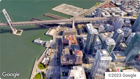
Aerial View API là một dịch vụ cho phép bạn tạo và hiển thị video trên không 3D siêu thực của mọi địa chỉ thực tế ở Hoa Kỳ. Các video này mô phỏng cảnh quay do một máy bay không người lái ghi lại khi bay vòng tròn trên cao.
Google đã tạo sẵn một tập dữ liệu gồm các video có chế độ xem từ trên không được kết xuất trước để bạn sử dụng. Những bức tranh này bao phủ các toà nhà và địa danh lớn trên khắp Hoa Kỳ.
Chúng tôi liên tục bổ sung thêm các video có chế độ xem từ trên không. Bạn có thể chỉ cần sử dụng những video hiện có này hoặc nếu chưa có video cho một địa chỉ, bạn có thể yêu cầu Google tạo một video mới cho bạn.
Lý do nên sử dụng Aerial View API
Dưới đây là một số lý do khiến bạn nên sử dụng Aerial View API.
Bạn muốn khám phá dữ liệu 3D nhưng không muốn sử dụng 3D Tiles hoặc làm việc với một trình kết xuất
Bạn thích bối cảnh của hình ảnh vệ tinh và khả năng nhận diện mặt tiền của một toà nhà trong Chế độ xem đường phố
Bạn đã cân nhắc việc thuê một người vận hành máy bay không người lái để quay phim về cơ sở lưu trú của mình
Bạn muốn sử dụng công nghệ tiên tiến và sáng tạo
Bạn cảm thấy thoải mái khi nhúng video vào trang web của mình
Những việc bạn có thể làm với Aerial View API
Dưới đây là danh sách một số việc bạn có thể làm với Aerial View API.
Cung cấp thông tin tổng quan về một toà nhà bằng cách làm nổi bật các con đường, công viên hoặc vùng nước lân cận
Giúp người thuê hoặc người mua nhà tiềm năng hình dung được một căn nhà như thế nào
Thiết lập bối cảnh cho video dạng ngắn để cho người xem biết bạn đang ở đâu
Làm nổi bật các điểm tham quan hoặc địa điểm yêu thích khi giúp người dùng lên kế hoạch cho kỳ nghỉ
Giúp người lái xe giao hàng hoặc người mua sắm tìm thấy địa điểm kinh doanh của bạn
Cách hoạt động của Aerial View API
Bạn có thể sử dụng Aerial View API theo 2 cách.
Phương pháp
Lý do
Tìm video được tạo
Google đã kết xuất tất cả hình ảnh trên không mà bạn cần (tập dữ liệu được kết xuất trước của Google).
Tạo video mới
Bạn cần hình ảnh ở chế độ xem từ trên không chưa được Google kết xuất trước.
Vùng phủ sóng
Aerial View API chỉ hỗ trợ địa chỉ bưu chính ở Hoa Kỳ, nơi Google có thể kết xuất video 3D.
Cách sử dụng Aerial View API
1
Xem Điều khoản dịch vụ của Nền tảng Google Maps
Xin lưu ý rằng bạn không thể tải xuống, lưu trữ hoặc lưu vào bộ nhớ đệm các video về chế độ xem từ trên không.
Để biết thêm thông tin, hãy xem
Điều khoản dịch vụ của Nền tảng Google Maps.
Truy xuất siêu dữ liệu của video về chế độ xem từ trên không
Gửi địa chỉ bưu điện ở Hoa Kỳ hoặc videoId đến điểm cuối lookupVideoMetadata() để trả về siêu dữ liệu của video về chế độ xem từ trên không.
Xem phần Truy xuất siêu dữ liệu của video.
4
Tìm nạp một video nhìn từ trên cao hiện có
Gửi địa chỉ bưu chính ở Hoa Kỳ hoặc videoId đến điểm cuối lookupVideo() để trả về video quay từ trên không đã được kết xuất trước.
Xem phần Tìm nạp video được tạo.
5
Tạo video mới về chế độ xem từ trên không
Gửi địa chỉ bưu chính của Hoa Kỳ đến điểm cuối renderVideo() để yêu cầu tạo một video mới về chế độ xem từ trên không cho địa chỉ đã chỉ định.
Xem phần Tạo video mới.
[null,null,["Cập nhật lần gần đây nhất: 2025-08-31 UTC."],[[["\u003cp\u003eThe Aerial View API lets you create and display photorealistic 3D aerial videos of US addresses, simulating drone footage.\u003c/p\u003e\n"],["\u003cp\u003eGoogle provides a pre-rendered video dataset for many locations, or you can request new videos to be generated.\u003c/p\u003e\n"],["\u003cp\u003eUse the API to enhance user experiences with interactive 3D aerial views for various applications, such as real estate, travel planning, and business listings.\u003c/p\u003e\n"],["\u003cp\u003eAccess and display videos through the API, but note that downloading or storing them locally is not permitted.\u003c/p\u003e\n"],["\u003cp\u003eThe API is limited to US addresses where 3D video rendering is supported by Google.\u003c/p\u003e\n"]]],[],null,["The Aerial View API is a service that lets you create and display\nphotorealistic 3D aerial videos of any physical address within the United\nStates. The videos simulate footage taken by a drone circling overhead.\n\nGoogle has already created a dataset of pre-rendered aerial view videos for you\nto use. They cover large buildings and landmarks throughout the United States.\nAnd we're adding more aerial view videos all the time. You can simply use these\nexisting videos or, if a video does not yet exist for an address, you can\nrequest that Google generate a new one for you.\n| **Note:** Google automatically pre-renders videos for addresses periodically, so some addresses will have no wait time.\n\nWhy use Aerial View API\n\nHere are some reasons why you might want to use Aerial View API.\n\n- You want to explore 3D data, but you're not comfortable using 3D Tiles, or with working with a renderer\n\n- You like the context of satellite imagery, and the ability to recognize a building facade from Street View\n\n- You've considered hiring a drone operator to film your property\n\n- You want to use cutting-edge, innovative technology\n\n- You're comfortable embedding video in your web site\n\nWhat you can do with Aerial View API\n\nHere's a list of some of the things you can do with Aerial View API.\n\n- Provide birds-eye awareness of a building by highlighting nearby roads, parks, or bodies of water\n\n- Give a prospective renter or home buyer a sense of what a property is like\n\n- Set the scene for a short-form video showing the viewer where you are\n\n- Highlight attractions or points-of-interest when helping users plan a vacation\n\n- Help delivery drivers or shoppers find your place of business\n\nHow the Aerial View API works\n\nThere are two approaches that you can take to use the Aerial View API.\n| **Tip:** Both of these approaches should begin with you checking whether the video exists using the [`lookupVideoMetadata`](/maps/documentation/aerial-view/lookup-video-metadata) endpoint.\n\n| Approach | Rationale |\n|--------------------------|--------------------------------------------------------------------------------------------------------------|\n| Lookup a generated video | All of the aerial imagery that you need has already been rendered by Google (Google's pre-rendered dataset). |\n| Generate a new video | You need aerial view imagery that hasn't already been pre-rendered by Google. |\n\nCoverage areas\n\nAerial View API only supports postal addresses in the United States where\nGoogle is able to render 3D videos.\n\nHow to use the Aerial View API\n\n|---|------------------------------------------------------|----------------------------------------------------------------------------------------------------------------------------------------------------------------------------------------------------------------------|\n| 1 | **Review the Google Maps Platform Terms of Service** | Note that you cannot download, store, or cache the aerial view videos. For more information, see the [Google Maps Platform Terms of Service](https://cloud.google.com/maps-platform/terms/). |\n| 2 | **Get set up** | Start with [Set up your Google Cloud project](/maps/documentation/aerial-view/cloud-setup) and complete the instructions that follow. |\n| 3 | **Retrieve an aerial view video's metadata** | Send a US postal address or `videoId` to the `lookupVideoMetadata()` endpoint to return an aerial view video's metadata. See [Retrieve a video's metadata.](/maps/documentation/aerial-view/lookup-video-metadata) |\n| 4 | **Fetch an existing aerial view video** | Send a US postal address or `videoId` to the `lookupVideo()` endpoint to return a pre-rendered aerial view video. See [Fetch a generated video.](/maps/documentation/aerial-view/lookup-video) |\n| 5 | **Generate a new aerial view video** | Send a US postal address to the `renderVideo()` endpoint to request the generation of a new aerial view video for the specified address. See [Generate a new video.](/maps/documentation/aerial-view/generate-video) |"]]