Mantieni tutto organizzato con le raccolte
Salva e classifica i contenuti in base alle tue preferenze.
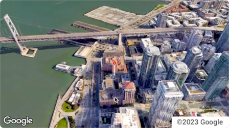
L'API Aerial View è un servizio che consente di creare e visualizzare video aerei 3D fotorealistici di qualsiasi indirizzo fisico all'interno degli Stati Uniti. I video simulano il filmato girato da un drone in volo.
Google ha già creato un set di dati di video con visuale aerea pre-renderizzati
che puoi utilizzare. Coprono grandi edifici e monumenti in tutti gli Stati Uniti.
Inoltre, aggiungiamo costantemente nuovi video con visuale aerea. Puoi semplicemente utilizzare questi video esistenti o, se non esiste ancora un video per un indirizzo, puoi richiedere a Google di generarne uno nuovo.
Perché utilizzare l'API Aerial View
Ecco alcuni motivi per cui potresti voler utilizzare l'API Aerial View.
Vuoi esplorare i dati 3D, ma non ti trovi a tuo agio con l'utilizzo di 3D Tiles o con l'utilizzo di un renderer
Ti piace il contesto delle immagini satellitari e la possibilità di riconoscere la facciata di un edificio da Street View
Hai preso in considerazione l'idea di assumere un operatore di droni per filmare la tua proprietà
Vuoi utilizzare una tecnologia innovativa e all'avanguardia
Ti trovi a tuo agio a incorporare video nel tuo sito web
Cosa puoi fare con l'API Aerial View
Ecco un elenco di alcune delle cose che puoi fare con l'API Aerial View.
Fornire una visione d'insieme di un edificio evidenziando strade, parchi o specchi d'acqua nelle vicinanze
Dare a un potenziale affittuario o acquirente un'idea di come sia una proprietà
Prepara la scena per un video nel formato breve che mostri allo spettatore dove ti trovi.
Evidenziare attrazioni o punti di interesse quando aiuti gli utenti a pianificare una vacanza
Aiutare i corrieri o gli acquirenti a trovare la tua attività
Come funziona l'API Aerial View
Esistono due approcci che puoi adottare per utilizzare l'API Aerial View.
Approccio
Motivazione
Cercare un video generato
Tutte le immagini aeree di cui hai bisogno sono già state sottoposte a rendering da Google (dataset pre-renderizzato di Google).
Generare un nuovo video
Hai bisogno di immagini della visuale aerea che non siano già state prerenderizzate da Google.
Aree di copertura
L'API Aerial View supporta solo gli indirizzi postali negli Stati Uniti in cui
Google è in grado di eseguire il rendering di video 3D.
Come utilizzare l'API Aerial View
1
Rivedi i Termini di servizio di Google Maps Platform
Tieni presente che non puoi scaricare, archiviare o memorizzare nella cache i video della visuale aerea.
Per ulteriori informazioni, consulta i
Termini di servizio di Google Maps Platform.
Recuperare i metadati di un video con visuale aerea
Invia un indirizzo postale statunitense o videoId all'endpoint lookupVideoMetadata() per restituire i metadati di un video con visuale aerea.
Consulta Recuperare i metadati di un video.
4
Recuperare un video esistente della visuale aerea
Invia un indirizzo postale statunitense o videoId all'endpoint lookupVideo() per restituire un video con visuale aerea pre-renderizzata.
Consulta Recuperare un video generato.
5
Generare un nuovo video con visuale aerea
Invia un indirizzo postale statunitense all'endpoint renderVideo() per
richiedere la generazione di un nuovo video della visuale aerea per l'indirizzo specificato.
Vedi Generare un nuovo video.
[null,null,["Ultimo aggiornamento 2025-08-31 UTC."],[[["\u003cp\u003eThe Aerial View API lets you create and display photorealistic 3D aerial videos of US addresses, simulating drone footage.\u003c/p\u003e\n"],["\u003cp\u003eGoogle provides a pre-rendered video dataset for many locations, or you can request new videos to be generated.\u003c/p\u003e\n"],["\u003cp\u003eUse the API to enhance user experiences with interactive 3D aerial views for various applications, such as real estate, travel planning, and business listings.\u003c/p\u003e\n"],["\u003cp\u003eAccess and display videos through the API, but note that downloading or storing them locally is not permitted.\u003c/p\u003e\n"],["\u003cp\u003eThe API is limited to US addresses where 3D video rendering is supported by Google.\u003c/p\u003e\n"]]],[],null,["The Aerial View API is a service that lets you create and display\nphotorealistic 3D aerial videos of any physical address within the United\nStates. The videos simulate footage taken by a drone circling overhead.\n\nGoogle has already created a dataset of pre-rendered aerial view videos for you\nto use. They cover large buildings and landmarks throughout the United States.\nAnd we're adding more aerial view videos all the time. You can simply use these\nexisting videos or, if a video does not yet exist for an address, you can\nrequest that Google generate a new one for you.\n| **Note:** Google automatically pre-renders videos for addresses periodically, so some addresses will have no wait time.\n\nWhy use Aerial View API\n\nHere are some reasons why you might want to use Aerial View API.\n\n- You want to explore 3D data, but you're not comfortable using 3D Tiles, or with working with a renderer\n\n- You like the context of satellite imagery, and the ability to recognize a building facade from Street View\n\n- You've considered hiring a drone operator to film your property\n\n- You want to use cutting-edge, innovative technology\n\n- You're comfortable embedding video in your web site\n\nWhat you can do with Aerial View API\n\nHere's a list of some of the things you can do with Aerial View API.\n\n- Provide birds-eye awareness of a building by highlighting nearby roads, parks, or bodies of water\n\n- Give a prospective renter or home buyer a sense of what a property is like\n\n- Set the scene for a short-form video showing the viewer where you are\n\n- Highlight attractions or points-of-interest when helping users plan a vacation\n\n- Help delivery drivers or shoppers find your place of business\n\nHow the Aerial View API works\n\nThere are two approaches that you can take to use the Aerial View API.\n| **Tip:** Both of these approaches should begin with you checking whether the video exists using the [`lookupVideoMetadata`](/maps/documentation/aerial-view/lookup-video-metadata) endpoint.\n\n| Approach | Rationale |\n|--------------------------|--------------------------------------------------------------------------------------------------------------|\n| Lookup a generated video | All of the aerial imagery that you need has already been rendered by Google (Google's pre-rendered dataset). |\n| Generate a new video | You need aerial view imagery that hasn't already been pre-rendered by Google. |\n\nCoverage areas\n\nAerial View API only supports postal addresses in the United States where\nGoogle is able to render 3D videos.\n\nHow to use the Aerial View API\n\n|---|------------------------------------------------------|----------------------------------------------------------------------------------------------------------------------------------------------------------------------------------------------------------------------|\n| 1 | **Review the Google Maps Platform Terms of Service** | Note that you cannot download, store, or cache the aerial view videos. For more information, see the [Google Maps Platform Terms of Service](https://cloud.google.com/maps-platform/terms/). |\n| 2 | **Get set up** | Start with [Set up your Google Cloud project](/maps/documentation/aerial-view/cloud-setup) and complete the instructions that follow. |\n| 3 | **Retrieve an aerial view video's metadata** | Send a US postal address or `videoId` to the `lookupVideoMetadata()` endpoint to return an aerial view video's metadata. See [Retrieve a video's metadata.](/maps/documentation/aerial-view/lookup-video-metadata) |\n| 4 | **Fetch an existing aerial view video** | Send a US postal address or `videoId` to the `lookupVideo()` endpoint to return a pre-rendered aerial view video. See [Fetch a generated video.](/maps/documentation/aerial-view/lookup-video) |\n| 5 | **Generate a new aerial view video** | Send a US postal address to the `renderVideo()` endpoint to request the generation of a new aerial view video for the specified address. See [Generate a new video.](/maps/documentation/aerial-view/generate-video) |"]]