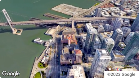
Aerial View API は、米国内の住所を実際の空中写真のような 3D 動画で表示するためのサービスです。動画では、ドローンで撮影された映像をシミュレートしています。
Google は、使用できる事前レンダリングされた鳥瞰図動画のデータセットをすでに作成しています。米国全土の大きな建物やランドマークを網羅しています。航空写真の動画は随時追加されています。これらの既存の動画をそのまま使用することも、住所の動画がまだ存在しない場合は、Google に新しい動画の生成をリクエストすることもできます。
Aerial View API を使用する理由
Aerial View API を使用する理由としては、次のようなものがあります。
3D データを探索したいが、3D Tiles の使用やレンダラでの作業に慣れていない
衛星画像のコンテキストと、ストリートビューから建物のファサードを認識する機能が気に入っている
物件の撮影にドローン オペレーターの雇用を検討している
最先端の革新的なテクノロジーを使用したい
ウェブサイトに動画を埋め込むことに慣れている
Aerial View API でできること
Aerial View API でできることを以下に示します。
近くの道路、公園、水域をハイライト表示して、建物の鳥瞰図を表示する
賃貸希望者や住宅購入希望者に物件の様子を伝える
視聴者に自分の居場所を示す短い動画のシーンを設定する
ユーザーが休暇を計画する際に、観光スポットやスポットをハイライト表示する
配達員や買い物客がビジネスの場所を見つけられるようにする
Aerial View API の仕組み
Aerial View API を使用するには、次の 2 つの方法があります。
アプローチ
根拠
生成された動画を検索する
必要な航空写真はすべて Google によってすでにレンダリングされています(Google の事前レンダリングされたデータセット)。
新しい動画を生成する
Google によって事前にレンダリングされていない航空写真が必要です。
対象地域
Aerial View API は、Google が 3D 動画をレンダリングできる米国の住所のみをサポートしています。
[null,null,["最終更新日 2025-08-31 UTC。"],[[["\u003cp\u003eThe Aerial View API lets you create and display photorealistic 3D aerial videos of US addresses, simulating drone footage.\u003c/p\u003e\n"],["\u003cp\u003eGoogle provides a pre-rendered video dataset for many locations, or you can request new videos to be generated.\u003c/p\u003e\n"],["\u003cp\u003eUse the API to enhance user experiences with interactive 3D aerial views for various applications, such as real estate, travel planning, and business listings.\u003c/p\u003e\n"],["\u003cp\u003eAccess and display videos through the API, but note that downloading or storing them locally is not permitted.\u003c/p\u003e\n"],["\u003cp\u003eThe API is limited to US addresses where 3D video rendering is supported by Google.\u003c/p\u003e\n"]]],[],null,["The Aerial View API is a service that lets you create and display\nphotorealistic 3D aerial videos of any physical address within the United\nStates. The videos simulate footage taken by a drone circling overhead.\n\nGoogle has already created a dataset of pre-rendered aerial view videos for you\nto use. They cover large buildings and landmarks throughout the United States.\nAnd we're adding more aerial view videos all the time. You can simply use these\nexisting videos or, if a video does not yet exist for an address, you can\nrequest that Google generate a new one for you.\n| **Note:** Google automatically pre-renders videos for addresses periodically, so some addresses will have no wait time.\n\nWhy use Aerial View API\n\nHere are some reasons why you might want to use Aerial View API.\n\n- You want to explore 3D data, but you're not comfortable using 3D Tiles, or with working with a renderer\n\n- You like the context of satellite imagery, and the ability to recognize a building facade from Street View\n\n- You've considered hiring a drone operator to film your property\n\n- You want to use cutting-edge, innovative technology\n\n- You're comfortable embedding video in your web site\n\nWhat you can do with Aerial View API\n\nHere's a list of some of the things you can do with Aerial View API.\n\n- Provide birds-eye awareness of a building by highlighting nearby roads, parks, or bodies of water\n\n- Give a prospective renter or home buyer a sense of what a property is like\n\n- Set the scene for a short-form video showing the viewer where you are\n\n- Highlight attractions or points-of-interest when helping users plan a vacation\n\n- Help delivery drivers or shoppers find your place of business\n\nHow the Aerial View API works\n\nThere are two approaches that you can take to use the Aerial View API.\n| **Tip:** Both of these approaches should begin with you checking whether the video exists using the [`lookupVideoMetadata`](/maps/documentation/aerial-view/lookup-video-metadata) endpoint.\n\n| Approach | Rationale |\n|--------------------------|--------------------------------------------------------------------------------------------------------------|\n| Lookup a generated video | All of the aerial imagery that you need has already been rendered by Google (Google's pre-rendered dataset). |\n| Generate a new video | You need aerial view imagery that hasn't already been pre-rendered by Google. |\n\nCoverage areas\n\nAerial View API only supports postal addresses in the United States where\nGoogle is able to render 3D videos.\n\nHow to use the Aerial View API\n\n|---|------------------------------------------------------|----------------------------------------------------------------------------------------------------------------------------------------------------------------------------------------------------------------------|\n| 1 | **Review the Google Maps Platform Terms of Service** | Note that you cannot download, store, or cache the aerial view videos. For more information, see the [Google Maps Platform Terms of Service](https://cloud.google.com/maps-platform/terms/). |\n| 2 | **Get set up** | Start with [Set up your Google Cloud project](/maps/documentation/aerial-view/cloud-setup) and complete the instructions that follow. |\n| 3 | **Retrieve an aerial view video's metadata** | Send a US postal address or `videoId` to the `lookupVideoMetadata()` endpoint to return an aerial view video's metadata. See [Retrieve a video's metadata.](/maps/documentation/aerial-view/lookup-video-metadata) |\n| 4 | **Fetch an existing aerial view video** | Send a US postal address or `videoId` to the `lookupVideo()` endpoint to return a pre-rendered aerial view video. See [Fetch a generated video.](/maps/documentation/aerial-view/lookup-video) |\n| 5 | **Generate a new aerial view video** | Send a US postal address to the `renderVideo()` endpoint to request the generation of a new aerial view video for the specified address. See [Generate a new video.](/maps/documentation/aerial-view/generate-video) |"]]