Zadbaj o dobrą organizację dzięki kolekcji
Zapisuj i kategoryzuj treści zgodnie ze swoimi preferencjami.
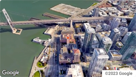
Aerial View API to usługa umożliwiająca tworzenie i wyświetlanie fotorealistycznych filmów 3D z lotu ptaka przedstawiających dowolny adres fizyczny na terenie Stanów Zjednoczonych. Filmy symulują materiały nagrane z góry przez drona.
Google utworzył już dla Ciebie zbiór danych z wstępnie wyrenderowanymi filmami z widokiem z lotu ptaka, z którego możesz korzystać. Obejmują one duże budynki i obiekty w całych Stanach Zjednoczonych.
Stale dodajemy kolejne filmy z widokiem z lotu ptaka. Możesz po prostu użyć tych filmów lub, jeśli dla danego adresu nie ma jeszcze filmu, możesz poprosić Google o wygenerowanie nowego.
Dlaczego warto używać interfejsu Aerial View API
Oto kilka powodów, dla których warto korzystać z interfejsu Aerial View API.
Chcesz eksplorować dane 3D, ale nie czujesz się komfortowo z używaniem 3D Tiles ani z przetwarzaniem obrazu.
Lubisz kontekst zdjęć satelitarnych i możliwość rozpoznania fasady budynku na zdjęciach Street View.
Rozważasz zatrudnienie operatora drona do sfilmowania Twojej nieruchomości.
Chcesz korzystać z najnowocześniejszych, innowacyjnych technologii.
umieszczać filmy w witrynie.
Możliwości interfejsu Aerial View API
Oto lista niektórych funkcji interfejsu Aerial View API.
Zapewnij widok z lotu ptaka na budynek, wyróżniając pobliskie drogi, parki lub zbiorniki wodne.
Pomóż potencjalnemu najemcy lub kupującemu zapoznać się z nieruchomością
Ustaw scenę dla krótkiego filmu, aby pokazać widzowi, gdzie jesteś.
Wskazywanie atrakcji lub ciekawych miejsc podczas pomagania użytkownikom w planowaniu wakacji
Pomóż dostawcom lub kupującym znaleźć Twoją firmę
Jak działa interfejs Aerial View API
Interfejsu Aerial View API możesz używać na 2 sposoby.
Podejście
Uzasadnienie
Wyszukiwanie wygenerowanego filmu
Wszystkie potrzebne zdjęcia lotnicze zostały już wyrenderowane przez Google (wstępnie wyrenderowany zbiór danych Google).
Generowanie nowego filmu
Potrzebujesz zdjęć z widoku z lotu ptaka, które nie zostały jeszcze wstępnie wyrenderowane przez Google.
Obszary objęte ochroną
Aerial View API obsługuje tylko adresy pocztowe w Stanach Zjednoczonych, w przypadku których Google może renderować filmy 3D.
Jak korzystać z interfejsu Aerial View API
1
Zapoznaj się z Warunkami korzystania z usługi Google Maps Platform
Pamiętaj, że nie możesz pobierać, przechowywać ani zapisywać w pamięci podręcznej filmów z widokiem z lotu ptaka.
Więcej informacji znajdziesz w
Warunkach korzystania z Google Maps Platform.
Pobieranie metadanych filmu z widokiem z lotu ptaka
Wyślij adres pocztowy w Stanach Zjednoczonych lub videoId do punktu końcowego lookupVideoMetadata(), aby uzyskać metadane filmu z widokiem z lotu ptaka.
Więcej informacji znajdziesz w artykule Pobieranie metadanych filmu.
4
Pobieranie istniejącego filmu symulującego widok z lotu ptaka
Wyślij adres pocztowy w Stanach Zjednoczonych lub videoId do punktu końcowego lookupVideo(), aby otrzymać wstępnie wyrenderowany film z widokiem z lotu ptaka.
Zobacz Pobieranie wygenerowanego filmu.
5
Generowanie nowego filmu z widokiem z lotu ptaka
Wyślij adres pocztowy w Stanach Zjednoczonych do punktu końcowego renderVideo(), aby poprosić o wygenerowanie nowego filmu z widokiem z lotu ptaka dla określonego adresu.
Zobacz Generowanie nowego filmu.
[null,null,["Ostatnia aktualizacja: 2025-08-31 UTC."],[[["\u003cp\u003eThe Aerial View API lets you create and display photorealistic 3D aerial videos of US addresses, simulating drone footage.\u003c/p\u003e\n"],["\u003cp\u003eGoogle provides a pre-rendered video dataset for many locations, or you can request new videos to be generated.\u003c/p\u003e\n"],["\u003cp\u003eUse the API to enhance user experiences with interactive 3D aerial views for various applications, such as real estate, travel planning, and business listings.\u003c/p\u003e\n"],["\u003cp\u003eAccess and display videos through the API, but note that downloading or storing them locally is not permitted.\u003c/p\u003e\n"],["\u003cp\u003eThe API is limited to US addresses where 3D video rendering is supported by Google.\u003c/p\u003e\n"]]],[],null,["The Aerial View API is a service that lets you create and display\nphotorealistic 3D aerial videos of any physical address within the United\nStates. The videos simulate footage taken by a drone circling overhead.\n\nGoogle has already created a dataset of pre-rendered aerial view videos for you\nto use. They cover large buildings and landmarks throughout the United States.\nAnd we're adding more aerial view videos all the time. You can simply use these\nexisting videos or, if a video does not yet exist for an address, you can\nrequest that Google generate a new one for you.\n| **Note:** Google automatically pre-renders videos for addresses periodically, so some addresses will have no wait time.\n\nWhy use Aerial View API\n\nHere are some reasons why you might want to use Aerial View API.\n\n- You want to explore 3D data, but you're not comfortable using 3D Tiles, or with working with a renderer\n\n- You like the context of satellite imagery, and the ability to recognize a building facade from Street View\n\n- You've considered hiring a drone operator to film your property\n\n- You want to use cutting-edge, innovative technology\n\n- You're comfortable embedding video in your web site\n\nWhat you can do with Aerial View API\n\nHere's a list of some of the things you can do with Aerial View API.\n\n- Provide birds-eye awareness of a building by highlighting nearby roads, parks, or bodies of water\n\n- Give a prospective renter or home buyer a sense of what a property is like\n\n- Set the scene for a short-form video showing the viewer where you are\n\n- Highlight attractions or points-of-interest when helping users plan a vacation\n\n- Help delivery drivers or shoppers find your place of business\n\nHow the Aerial View API works\n\nThere are two approaches that you can take to use the Aerial View API.\n| **Tip:** Both of these approaches should begin with you checking whether the video exists using the [`lookupVideoMetadata`](/maps/documentation/aerial-view/lookup-video-metadata) endpoint.\n\n| Approach | Rationale |\n|--------------------------|--------------------------------------------------------------------------------------------------------------|\n| Lookup a generated video | All of the aerial imagery that you need has already been rendered by Google (Google's pre-rendered dataset). |\n| Generate a new video | You need aerial view imagery that hasn't already been pre-rendered by Google. |\n\nCoverage areas\n\nAerial View API only supports postal addresses in the United States where\nGoogle is able to render 3D videos.\n\nHow to use the Aerial View API\n\n|---|------------------------------------------------------|----------------------------------------------------------------------------------------------------------------------------------------------------------------------------------------------------------------------|\n| 1 | **Review the Google Maps Platform Terms of Service** | Note that you cannot download, store, or cache the aerial view videos. For more information, see the [Google Maps Platform Terms of Service](https://cloud.google.com/maps-platform/terms/). |\n| 2 | **Get set up** | Start with [Set up your Google Cloud project](/maps/documentation/aerial-view/cloud-setup) and complete the instructions that follow. |\n| 3 | **Retrieve an aerial view video's metadata** | Send a US postal address or `videoId` to the `lookupVideoMetadata()` endpoint to return an aerial view video's metadata. See [Retrieve a video's metadata.](/maps/documentation/aerial-view/lookup-video-metadata) |\n| 4 | **Fetch an existing aerial view video** | Send a US postal address or `videoId` to the `lookupVideo()` endpoint to return a pre-rendered aerial view video. See [Fetch a generated video.](/maps/documentation/aerial-view/lookup-video) |\n| 5 | **Generate a new aerial view video** | Send a US postal address to the `renderVideo()` endpoint to request the generation of a new aerial view video for the specified address. See [Generate a new video.](/maps/documentation/aerial-view/generate-video) |"]]