Оптимизируйте свои подборки
Сохраняйте и классифицируйте контент в соответствии со своими настройками.
Объекты, которые можно настроить, организованы в иерархическую структуру. Для каждого объекта можно задать один или несколько элементов стиля. У большинства объектов верхнего уровня есть дочерние объекты. При настройке стилей карты доступны следующие варианты:
Inherit from the base map style (Использовать стиль базовой карты). Если вы не зададите для объекта элемент стиля, будет использоваться стиль базовой карты по умолчанию.
Inherit from parents (Наследовать родительский стиль). Если вы измените элемент стиля родительского объекта, все дочерние объекты, для которых не настроен стиль, унаследуют родительский стиль.
Override the parent style (Переопределить родительский стиль). Если вы настроите элемент стиля дочернего объекта, родительский стиль для него будет переопределен.
Fill color (Цвет заливки) для многоугольников и ломаных линий.
Stroke color (Цвет контура) для многоугольников и ломаных линий.
Stroke weight (Толщина контура) для многоугольников и ломаных линий.
Не может быть равна 0. Если вам не нужен контур, задайте для него тот же цвет, что и для заливки.
Icon color (Цвет значка) – заливка значков.
Text fill color (Цвет заливки шрифта).
Text stroke color (Цвет контура шрифта).
Как показывать и скрывать объекты на карте
Чтобы показать или скрыть объекты определенного типа, используется элемент Visibility (Видимость).
Выберите объект в редакторе стилей.
Чтобы объект показывался, в разделе Visibility (Видимость) установите переключатель в положение On (Включить). Чтобы объект был скрыт, в разделе Visibility (Видимость) установите переключатель в положение Off (Выключить).
Многоугольники и ломаные линии
Для объектов, которые представляют собой фигуры (например, для пляжей, стран, городских площадей) или линии (для рельсового транспорта, шоссе, троп), как правило, можно настраивать видимость, цвет заливки и контура и толщину контура.
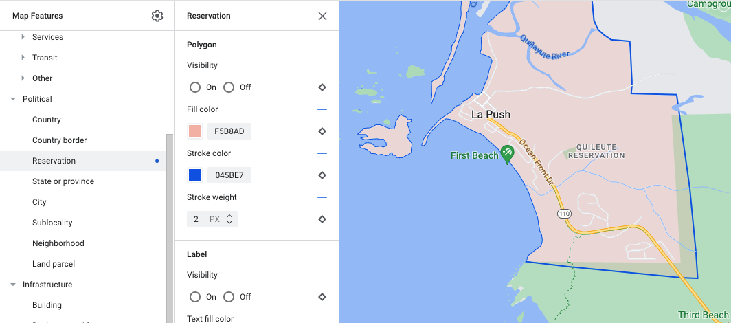
Настройка стиля многоугольника на примере объекта типа Reservation (Резервация)
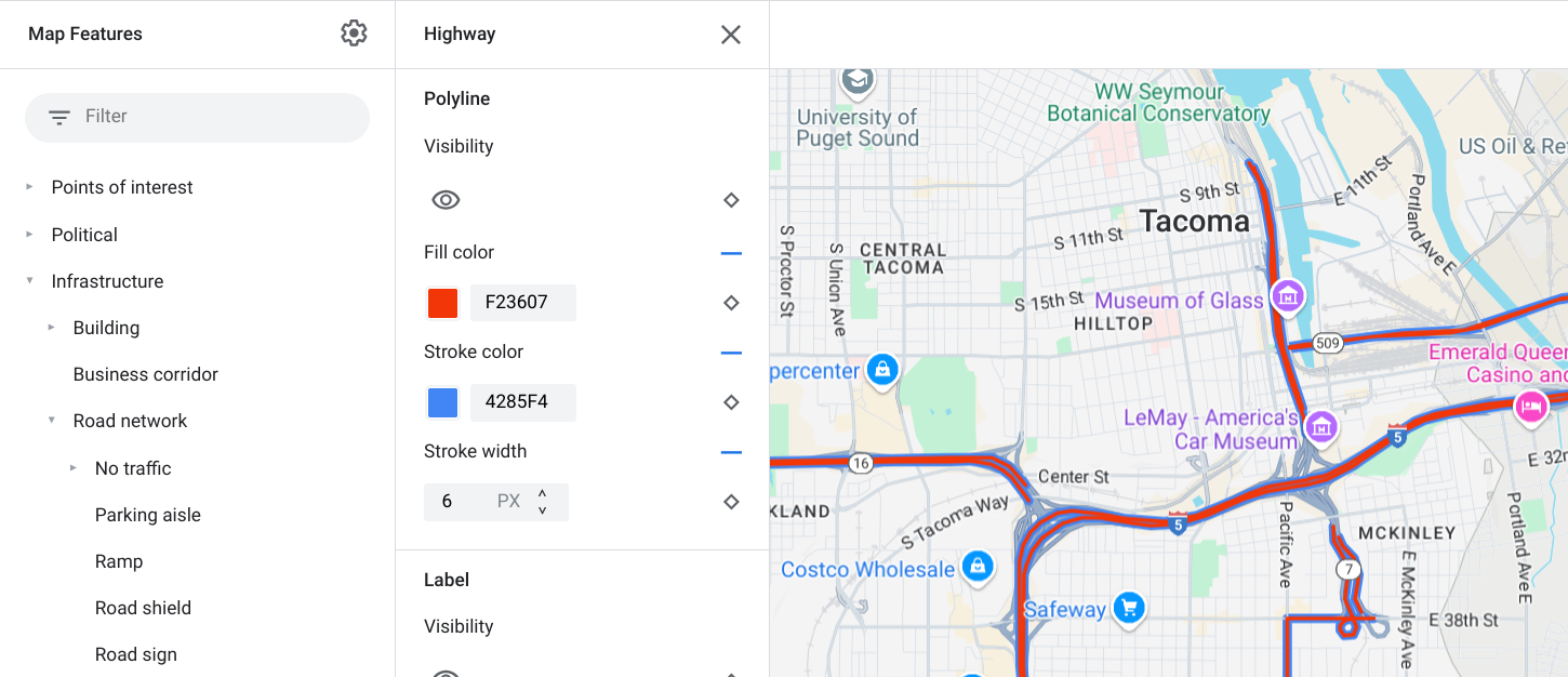
Настройка стиля ломаной линии на примере объекта Highway (Шоссе)
Значки и текстовые ярлыки
Для объектов, которые представляют собой ярлык или содержат его, например достопримечательности или транспорт, как правило, можно настраивать видимость, цвет значка и цвет заливки и контура текста.
Пример настройки стиля для текста и значка
Иерархия объектов на карте
В таблицах ниже указано, какие дочерние объекты есть у разных объектов верхнего уровня.
Points of interest (Объекты инфраструктуры)
Emergency (Службы экстренной помощи)
Fire (Пожарные)
Hospital (Больница)
Pharmacy (Аптека)
Police (Полиция)
Entertainment (Развлечения)
Arts (Искусство)
Casino (Казино)
Cinema (Кинотеатр)
Historic (Историческая достопримечательность)
Museum (Музей)
Theme park (Парк развлечений)
Tourist attraction (Туристический объект)
Food and drink (Еда и напитки)
Bar (Бар)
Cafe (Кафе)
Restaurant (Ресторан)
Winery (Винодельня)
Lodging (Жилье)
Recreation (Отдых)
Beach (Пляж)
Boating (Лодочный спорт)
Fishing (Рыбная ловля)
Golf course (Поле для гольфа)
Hot spring (Горячий источник)
Nature reserve (Природный заповедник)
Park (Парк)
Peak (Горная вершина)
Sports complex (Спортивный комплекс)
Sports field (Спортивная площадка)
Trailhead (Начало тропы)
Zoo (Зоопарк)
Retail (Розничная торговля)
Grocery (Продуктовый магазин)
Shopping (Магазин)
Services (Услуги)
ATM (Банкомат)
Bank (Банк)
Car rental (Аренда автомобилей)
EV charging (Станция зарядки электромобилей)
Gas station (Заправочная станция)
Parking lot (Парковка)
Post office (Отделение почты)
Rest stop (Площадка для отдыха)
Restroom (Туалет)
Transit (Общественный транспорт)
Airport (Аэропорт)
Other (Другое)
Bridge (Мост)
Cemetery (Кладбище)
Government (Государственное учреждение)
Library (Библиотека)
Military (Военный объект)
Place of worship (Культовое сооружение)
School (Школа)
Town square (Городская площадь)
Political (Административная единица)
Country (Страна)
Country border (Государственная граница)
Reservation (Резервация)
State or province (Штат или провинция)
City (Город)
Sublocality (Район)
Neighborhood (Квартал)
Land parcel (Земельный участок)
Infrastructure (Инфраструктура)
Building (Здание)
Business corridor (Деловая зона)
Road network (Дорожная сеть)
No traffic (Без движения транспорта)
Pedestrian mall (Пешеходная зона)
Trail (Тропа)
Parking aisle (Проход на парковке)
Road shield (Дорожный указатель)
Roads (Дороги)
Arterial (Автомагистраль)
Highway (Шоссе)
Local (Дорога местного значения)
No outlet (Тупик)
Railway track (Железнодорожный путь)
Transit station (Остановка общественного транспорта)
[null,null,["Последнее обновление: 2023-12-26 UTC."],[[["\u003cp\u003eCustomize the appearance of Google Maps by styling map features, including their visibility, colors, and outlines.\u003c/p\u003e\n"],["\u003cp\u003eMap features inherit styles from their parent features, but you can override these styles for individual features or zoom levels.\u003c/p\u003e\n"],["\u003cp\u003eChoose to show or hide specific map features using the visibility setting in the style editor.\u003c/p\u003e\n"],["\u003cp\u003eAdjust the styling of shapes and lines, such as polygons and polylines, by changing their fill color, stroke color, and stroke width, although some political features and 3D buildings have limitations.\u003c/p\u003e\n"],["\u003cp\u003eCustomize icons and text labels for points of interest and transportation elements by modifying their colors and outlines.\u003c/p\u003e\n"]]],[],null,["Select platform: [Android](/maps/documentation/android-sdk/cloud-customization/taxonomy \"View this page for the Android platform docs.\") [iOS](/maps/documentation/ios-sdk/cloud-customization/taxonomy \"View this page for the iOS platform docs.\") [JavaScript](/maps/documentation/javascript/cloud-customization/taxonomy \"View this page for the JavaScript platform docs.\") [Web Service](/maps/documentation/maps-static/cloud-customization/taxonomy \"View this page for the Web Service platform docs.\")\n\n\u003cbr /\u003e\n\n\nThe map features you can customize are arranged in a hierarchy, and each map\nfeature has one or more style elements that you can customize. Most top-level\nfeatures have one or more child map features. You have several options when\ncustomizing map styles:\n\n- **Inherit from the base map style**: If you don't customize a style element\n for a map feature, it inherits the default style from the base map.\n\n- **Inherit from parents**: Customize a style element on a parent map feature,\n to have all un-customized child map features below inherit the styles from\n their parent.\n\n- **Override the parent style**: Customize a style element on a child map\n feature to override the parent style for that element.\n\n- **Customize zoom levels** : For some map features, you can customize style\n elements for different zoom levels. For details, see [Style zoom\n levels](/maps/documentation/maps-static/cloud-customization/zoom-levels).\n\nWhat you can style for each map feature\n\nMap features can have one or more of the following style elements that you can\ncustomize, depending on the type of map feature:\n\n- **Visibility**: Whether to show or hide this feature on the map.\n\n- **Fill color**: Fill color for polygons and polylines.\n\n- **Stroke color**: Outline color for polygons and polylines.\n\n- **Stroke width**: Thickness of the outline for polygons and polylines.\n Results may vary depending on the zoom level. If you don't want an outline,\n set the Stroke color to be the same as the Fill color, or set the Stroke\n width to 0.\n\n- **Icon color**: Fill color for the icons.\n\n- **Text fill color**: Fill color for text labels.\n\n- **Text stroke color**: Outline color for text labels.\n\n| **Note:** Stroke color and Stroke width customizations are not available for all map features. For details, see [Polygons and Polylines](#polygons_and_polylines).\n\nMap feature visibility\n\nWhen you hide map features or make them transparent, you may expose boundary\ninaccuracies. Map feature boundaries are not always precise, but are adjusted to\nlook correct when all layers are visible. To learn more about how map layers\naffect each other, see [Manage styles that overlap](/maps/documentation/maps-static/cloud-customization/overlap).\n\nThere are two ways to show or hide map features: visibility and opacity.\n\nVisibility\n\nTo either display or hide a map feature on your map, use the **Visibility**\nstyle element. For more details, see\n[Filter which map features to display](/maps/documentation/maps-static/cloud-customization/viz).\n| **Note:** Not all map features are shown on the map at all zoom levels. To see the map feature displayed or hidden, you may need to zoom in or out.\n\nOpacity\n\nYou can also make a map feature transparent by adjusting the opacity of the\nfollowing style elements: Fill color, Stroke color, Text fill color, and Text\nstroke color. \n\nWhen you adjust the opacity of a map feature, its appearance depends on the map\nfeatures underneath. To avoid unexpected style changes, set a custom style for\nall overlapping features.\n| **Note:** Opacity is not available for all map features.\n\nPolygons and Polylines\n\nFor map feature types that are represented with a shape, such as Beach, Country,\nand Town square, or a line, such as Railway track, Highway, and Trail, you can\ntypically style the following elements: Visibility, Fill color, Stroke color,\nand Stroke width. \n\n*Polygon styling customization example - for **Reservation** feature type*\n\n*Polyline styling customization example - for **Highway** feature type*\n\nStroke color and Stroke width customizations are **not available** for the\nfollowing map features:\n\n- Political map features: Their style conveys meaning on the map, such\n as indicating the type of territory. The political map features are\n **Country** , **Border** , **State or province** , and **Sublocality**.\n\n- 3D style buildings.\n\nIcons and Text Labels\n\nFor map feature types that are fully or partially represented with a label, such\nas Point of interest or Transportation, you can usually style the following\nelements: Visibility, Icon color, Text fill color, and Text stroke color. \n\n*Label text and icon styling customizations example*\n\nMap feature hierarchy\n\nThese tables for the top level map features show what child map features are\navailable under each.\n\n| Point of interest ||\n|----------------|-----------------------------------------------------------------------------------------------------------------|\n| Emergency | Fire Hospital Pharmacy Police |\n| Entertainment | Arts Casino Cinema Historic Museum Theme park Tourist attraction |\n| Food and drink | Bar Cafe Restaurant Winery |\n| Landmark | |\n| Lodging | |\n| Recreation | Beach Boating Fishing Golf course Hot spring Nature reserve Park Peak Sports complex Sports field Trailhead Zoo |\n| Retail | Grocery Shopping |\n| Service | ATM Bank Car rental EV charging Gas station Parking lot Post office Rest stop Restroom |\n| Transit | Airport |\n| Other | Bridge Cemetery Government Library Military Place of worship School Town square |\n\n| Political ||\n|-------------------|---|\n| Country | |\n| Border | |\n| Reservation | |\n| State or province | |\n| City | |\n| Sublocality | |\n| Neighborhood | |\n| Land parcel | |\n\n| Infrastructure ||||\n|-------------------|---------------------|-----------------------------------------|---------------|\n| Building | Commercial | | |\n| Business corridor | | | |\n| Road network | No traffic | Pedestrian mall |\n| Road network | No traffic | Trail | Paved Unpaved |\n| Road network | Parking aisle | | |\n| Road network | Ramp | | |\n| Road network | Road shield | | |\n| Road network | Road sign | | |\n| Road network | Road | Arterial Highway Local No outlet | |\n| Road network | Road detail^\\*^ | Surface Crosswalk Sidewalk Intersection | |\n| Railway track | Commercial Commuter | | |\n| Transit station | Bicycle share | | |\n| Transit station | Bus station | | |\n| Transit station | Ferry terminal | | |\n| Transit station | Funicular station | | |\n| Transit station | Gondola station | | |\n| Transit station | Monorail | | |\n| Transit station | Rail station | Subway station Tram station | |\n| Urban area | | | |\n\n| Natural |||\n|-------------|------------------------|----------------------------------------------|\n| Continent | | |\n| Archipelago | | |\n| Island | | |\n| Land | Land cover^†^ | Crops Dry crops Forest Ice Sand Shrub Tundra |\n| Water | Ocean Lake River Other | |\n| Base | | |"]]