Mit Sammlungen den Überblick behalten
Sie können Inhalte basierend auf Ihren Einstellungen speichern und kategorisieren.
Die Kartenelemente, die Sie anpassen können, sind in einer Hierarchie angeordnet. Jedes Kartenelement hat mindestens ein Stilelement, das Sie anpassen können. Die meisten Elemente der obersten Ebene haben ein oder mehrere untergeordnete Kartenelemente. Beim Anpassen von Kartenstilen können Sie zwischen mehreren Möglichkeiten wählen:
Von Basiskartenstil übernehmen: Wenn Sie ein Stilelement für ein Kartenelement nicht anpassen, wird der Standardstil der Basiskarte dafür übernommen.
Von übergeordneten Elementen übernehmen: Wenn Sie ein Stilelement bei einem übergeordneten Kartenelement anpassen, wird der Stil des übergeordneten Kartenelements in alle nicht angepassten untergeordneten Kartenelemente übernommen.
Übergeordneten Stil überschreiben: Wenn Sie ein Stilelement auf einem untergeordneten Kartenelement anpassen, wird durch diese Anpassung der übergeordnete Stil in Bezug auf dieses Element überschrieben.
Zoomstufen anpassen: Bei einigen Kartenelementen können Sie Stilelemente für verschiedene Zoomstufen bearbeiten. Weitere Informationen finden Sie unter Zoomstufen gestalten.
Was Sie für jedes Kartenelement gestalten können
Kartenelemente können eines oder mehrere der folgenden Stilelemente haben, die Sie anpassen können (je nach Art des Kartenelements):
Sichtbarkeit: Bestimmt, ob dieses Element auf der Karte ein- oder ausgeblendet wird. Ausführliche Informationen finden Sie in Kartenelemente ein- oder ausblenden.
Füllfarbe: Füllfarbe für Polygone und Polylinien
Strichfarbe: Umrissfarbe für Polygone und Polylinien
Strichstärke: Dicke der Umrisslinie für Polygone und Polylinien.
Kann nicht auf „0“ gesetzt werden. Wenn das Element keinen Umriss haben soll, legen Sie als Strich- und Füllfarbe dieselbe Farbe fest.
Symbolfarbe: Füllfarbe für Symbole
Textfüllfarbe: Füllfarbe für Textlabels
Textstrichfarbe: Umrissfarbe für Textlabels
Kartenelemente ein- oder ausblenden
Wenn Sie bestimmte Kartenelemente ein- oder ausblenden möchten, verwenden Sie das Stilelement Sichtbarkeit:
Öffnen Sie den Stileditor und wählen Sie das Kartenelement aus.
Kartenelement einblenden: Wählen Sie unter Sichtbarkeit die Einstellung Ein aus. Kartenelement von der Karte entfernen: Legen Sie unter Sichtbarkeit die Einstellung Aus fest.
Polygone und Polylinien
Für Kartenelementtypen, die mit einer Form (z. B. „Strand“, „Land“ oder „Marktplatz“) oder einer Linie (z. B. „Bahn“, „Bundesstraße“ oder „Weg“) dargestellt werden, können Sie normalerweise folgende Elemente gestalten: „Sichtbarkeit“, „Füllfarbe“, „Strichfarbe“ und „Strichstärke“.
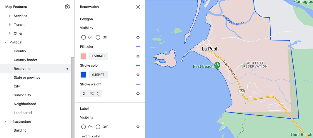
Beispiel für die Anpassung des Polygonstils (Elementtyp Reservat)
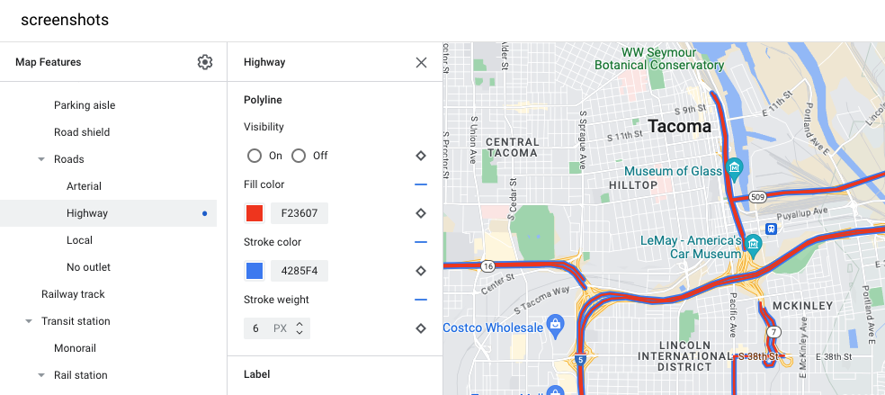
Beispiel für die Anpassung des Polylinienstils (Elementtyp Bundesstraße)
Symbole und Textlabels
Für Kartenelementtypen, die vollständig oder teilweise durch ein Label dargestellt werden (z. B. „POIs“ oder „Verkehr“), können Sie normalerweise die folgenden Elemente gestalten: „Sichtbarkeit“, „Symbolfarbe“, „Textfüllfarbe“ und „Textstrichfarbe“.
Beispiel für Anpassungen des Labeltext- und Symbolstils
Hierarchie von Kartenelementen
In diesen Tabellen für die Kartenelemente der obersten Ebene sehen Sie, welche untergeordneten Kartenelemente unter jedem Element verfügbar sind.
POIs
Notfall
Feuer
Krankenhaus
Apotheke
Polizei
Unterhaltung
Kunst
Casino
Kino
Historisch wertvoll
Museum
Themenpark
Touristenattraktion
[null,null,["Zuletzt aktualisiert: 2023-12-26 (UTC)."],[[["\u003cp\u003eCustomize the appearance of Google Maps by styling map features, including their visibility, colors, and outlines.\u003c/p\u003e\n"],["\u003cp\u003eMap features inherit styles from their parent features, but you can override these styles for individual features or zoom levels.\u003c/p\u003e\n"],["\u003cp\u003eChoose to show or hide specific map features using the visibility setting in the style editor.\u003c/p\u003e\n"],["\u003cp\u003eAdjust the styling of shapes and lines, such as polygons and polylines, by changing their fill color, stroke color, and stroke width, although some political features and 3D buildings have limitations.\u003c/p\u003e\n"],["\u003cp\u003eCustomize icons and text labels for points of interest and transportation elements by modifying their colors and outlines.\u003c/p\u003e\n"]]],[],null,["Select platform: [Android](/maps/documentation/android-sdk/cloud-customization/taxonomy \"View this page for the Android platform docs.\") [iOS](/maps/documentation/ios-sdk/cloud-customization/taxonomy \"View this page for the iOS platform docs.\") [JavaScript](/maps/documentation/javascript/cloud-customization/taxonomy \"View this page for the JavaScript platform docs.\") [Web Service](/maps/documentation/maps-static/cloud-customization/taxonomy \"View this page for the Web Service platform docs.\")\n\n\u003cbr /\u003e\n\n\nThe map features you can customize are arranged in a hierarchy, and each map\nfeature has one or more style elements that you can customize. Most top-level\nfeatures have one or more child map features. You have several options when\ncustomizing map styles:\n\n- **Inherit from the base map style**: If you don't customize a style element\n for a map feature, it inherits the default style from the base map.\n\n- **Inherit from parents**: Customize a style element on a parent map feature,\n to have all un-customized child map features below inherit the styles from\n their parent.\n\n- **Override the parent style**: Customize a style element on a child map\n feature to override the parent style for that element.\n\n- **Customize zoom levels** : For some map features, you can customize style\n elements for different zoom levels. For details, see [Style zoom\n levels](/maps/documentation/maps-static/cloud-customization/zoom-levels).\n\nWhat you can style for each map feature\n\nMap features can have one or more of the following style elements that you can\ncustomize, depending on the type of map feature:\n\n- **Visibility**: Whether to show or hide this feature on the map.\n\n- **Fill color**: Fill color for polygons and polylines.\n\n- **Stroke color**: Outline color for polygons and polylines.\n\n- **Stroke width**: Thickness of the outline for polygons and polylines.\n Results may vary depending on the zoom level. If you don't want an outline,\n set the Stroke color to be the same as the Fill color, or set the Stroke\n width to 0.\n\n- **Icon color**: Fill color for the icons.\n\n- **Text fill color**: Fill color for text labels.\n\n- **Text stroke color**: Outline color for text labels.\n\n| **Note:** Stroke color and Stroke width customizations are not available for all map features. For details, see [Polygons and Polylines](#polygons_and_polylines).\n\nMap feature visibility\n\nWhen you hide map features or make them transparent, you may expose boundary\ninaccuracies. Map feature boundaries are not always precise, but are adjusted to\nlook correct when all layers are visible. To learn more about how map layers\naffect each other, see [Manage styles that overlap](/maps/documentation/maps-static/cloud-customization/overlap).\n\nThere are two ways to show or hide map features: visibility and opacity.\n\nVisibility\n\nTo either display or hide a map feature on your map, use the **Visibility**\nstyle element. For more details, see\n[Filter which map features to display](/maps/documentation/maps-static/cloud-customization/viz).\n| **Note:** Not all map features are shown on the map at all zoom levels. To see the map feature displayed or hidden, you may need to zoom in or out.\n\nOpacity\n\nYou can also make a map feature transparent by adjusting the opacity of the\nfollowing style elements: Fill color, Stroke color, Text fill color, and Text\nstroke color. \n\nWhen you adjust the opacity of a map feature, its appearance depends on the map\nfeatures underneath. To avoid unexpected style changes, set a custom style for\nall overlapping features.\n| **Note:** Opacity is not available for all map features.\n\nPolygons and Polylines\n\nFor map feature types that are represented with a shape, such as Beach, Country,\nand Town square, or a line, such as Railway track, Highway, and Trail, you can\ntypically style the following elements: Visibility, Fill color, Stroke color,\nand Stroke width. \n\n*Polygon styling customization example - for **Reservation** feature type*\n\n*Polyline styling customization example - for **Highway** feature type*\n\nStroke color and Stroke width customizations are **not available** for the\nfollowing map features:\n\n- Political map features: Their style conveys meaning on the map, such\n as indicating the type of territory. The political map features are\n **Country** , **Border** , **State or province** , and **Sublocality**.\n\n- 3D style buildings.\n\nIcons and Text Labels\n\nFor map feature types that are fully or partially represented with a label, such\nas Point of interest or Transportation, you can usually style the following\nelements: Visibility, Icon color, Text fill color, and Text stroke color. \n\n*Label text and icon styling customizations example*\n\nMap feature hierarchy\n\nThese tables for the top level map features show what child map features are\navailable under each.\n\n| Point of interest ||\n|----------------|-----------------------------------------------------------------------------------------------------------------|\n| Emergency | Fire Hospital Pharmacy Police |\n| Entertainment | Arts Casino Cinema Historic Museum Theme park Tourist attraction |\n| Food and drink | Bar Cafe Restaurant Winery |\n| Landmark | |\n| Lodging | |\n| Recreation | Beach Boating Fishing Golf course Hot spring Nature reserve Park Peak Sports complex Sports field Trailhead Zoo |\n| Retail | Grocery Shopping |\n| Service | ATM Bank Car rental EV charging Gas station Parking lot Post office Rest stop Restroom |\n| Transit | Airport |\n| Other | Bridge Cemetery Government Library Military Place of worship School Town square |\n\n| Political ||\n|-------------------|---|\n| Country | |\n| Border | |\n| Reservation | |\n| State or province | |\n| City | |\n| Sublocality | |\n| Neighborhood | |\n| Land parcel | |\n\n| Infrastructure ||||\n|-------------------|---------------------|-----------------------------------------|---------------|\n| Building | Commercial | | |\n| Business corridor | | | |\n| Road network | No traffic | Pedestrian mall |\n| Road network | No traffic | Trail | Paved Unpaved |\n| Road network | Parking aisle | | |\n| Road network | Ramp | | |\n| Road network | Road shield | | |\n| Road network | Road sign | | |\n| Road network | Road | Arterial Highway Local No outlet | |\n| Road network | Road detail^\\*^ | Surface Crosswalk Sidewalk Intersection | |\n| Railway track | Commercial Commuter | | |\n| Transit station | Bicycle share | | |\n| Transit station | Bus station | | |\n| Transit station | Ferry terminal | | |\n| Transit station | Funicular station | | |\n| Transit station | Gondola station | | |\n| Transit station | Monorail | | |\n| Transit station | Rail station | Subway station Tram station | |\n| Urban area | | | |\n\n| Natural |||\n|-------------|------------------------|----------------------------------------------|\n| Continent | | |\n| Archipelago | | |\n| Island | | |\n| Land | Land cover^†^ | Crops Dry crops Forest Ice Sand Shrub Tundra |\n| Water | Ocean Lake River Other | |\n| Base | | |"]]