Mantenha tudo organizado com as coleções
Salve e categorize o conteúdo com base nas suas preferências.
Os elementos do mapa que você pode personalizar são organizados em hierarquia, e cada um deles possui mais um elemento de estilo que você pode personalizar. A maioria dos elementos de nível superior tem um ou mais elementos de mapa secundários. Você tem várias opções para personalizar os estilos de mapa:
Herdar do estilo de mapa de base: se você não personalizar um elemento de estilo para um elemento de mapa, ele herdará o estilo padrão do mapa de base.
Herdar dos principais: personalize o estilo de um elemento principal do mapa para que todos os secundários não personalizados abaixo dele herdem a personalização.
Substituir o estilo principal: personalize o estilo de um elemento secundário do mapa para substituir o estilo do elemento principal.
Personalizar níveis de zoom: para alguns elementos do mapa, você pode personalizar os elementos de estilo para diferentes níveis de zoom. Para mais detalhes, confira Estilizar níveis de zoom.
O que você pode estilizar em cada elemento do mapa
Os elementos do mapa podem ter um ou mais dos seguintes elementos de estilo que você pode personalizar, dependendo do tipo:
Cor de preenchimento: a cor de preenchimento de polígonos e polilinhas.
Cor do traço: a cor do contorno de polígonos e polilinhas.
Espessura do traço: a espessura da linha de contorno de polígonos e polilinhas.
Não pode ser definido para 0. Se você não quiser um destaque, defina a cor do traço para a mesma cor de preenchimento.
Cor do ícone: a cor de preenchimento dos ícones.
Cor de preenchimento do texto: a cor de preenchimento dos rótulos de texto.
Cor do traço do texto: a cor do contorno dos rótulos de texto.
Mostrar ou ocultar elementos do mapa
Se você quiser mostrar ou ocultar elementos do mapa, use o elemento de estilo Visibilidade:
No editor de estilo, selecione o elemento do mapa.
Para mostrar o elemento do mapa: em Visibilidade, selecione Ativar. Para remover um elemento do mapa: em Visibilidade, selecione Desativar.
Polígonos e polilinhas
Para os tipos de elementos do mapa que são representados com uma forma (como Praia, País e Praça) ou uma linha (Ferrovia, Estrada, Trilha etc.), normalmente é possível definir o estilo dos seguintes elementos: Visibilidade, Cor de preenchimento, Cor do traço e Espessura do traço.
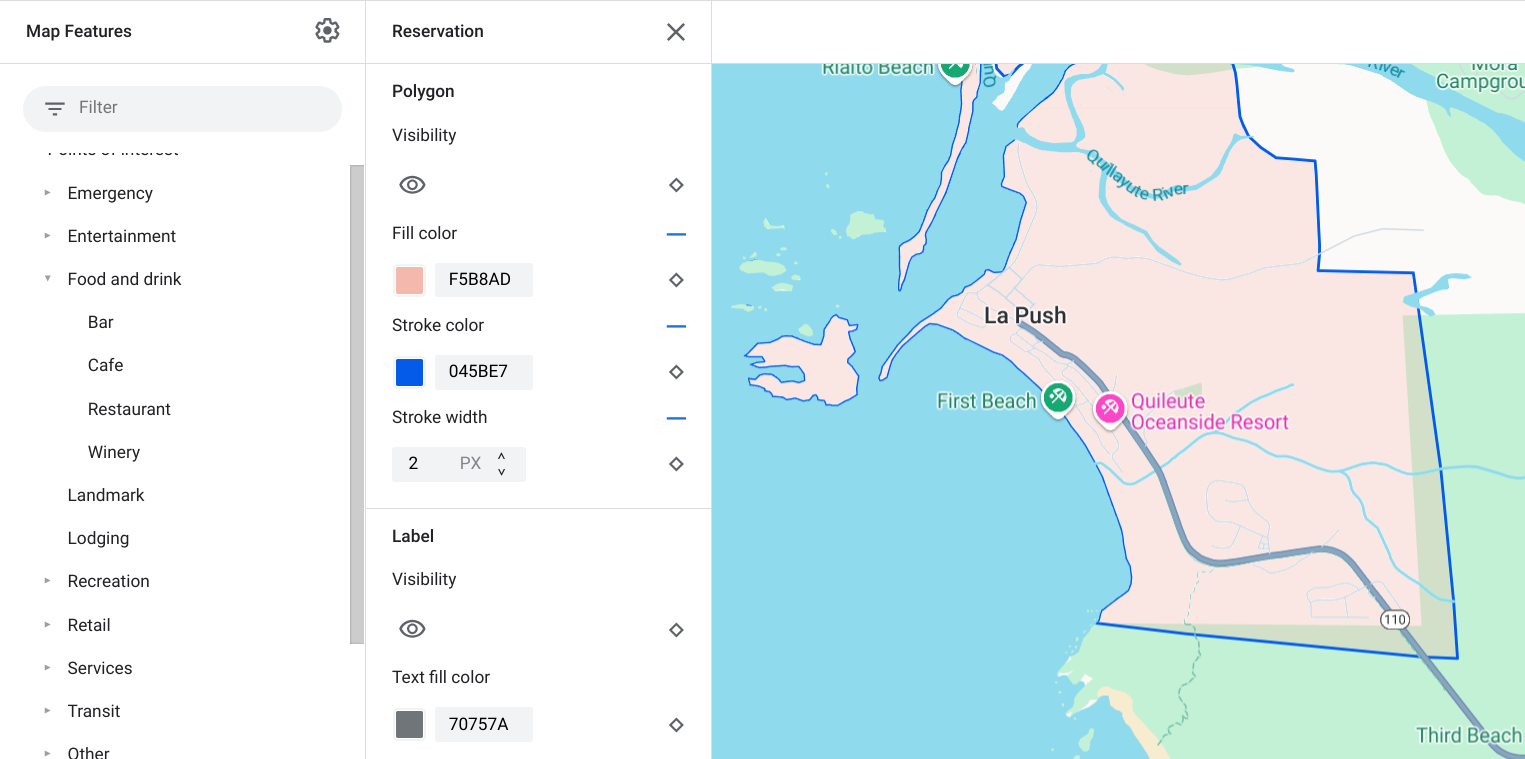
Exemplo de personalização de estilo do polígono: para o tipo de elemento Reserva
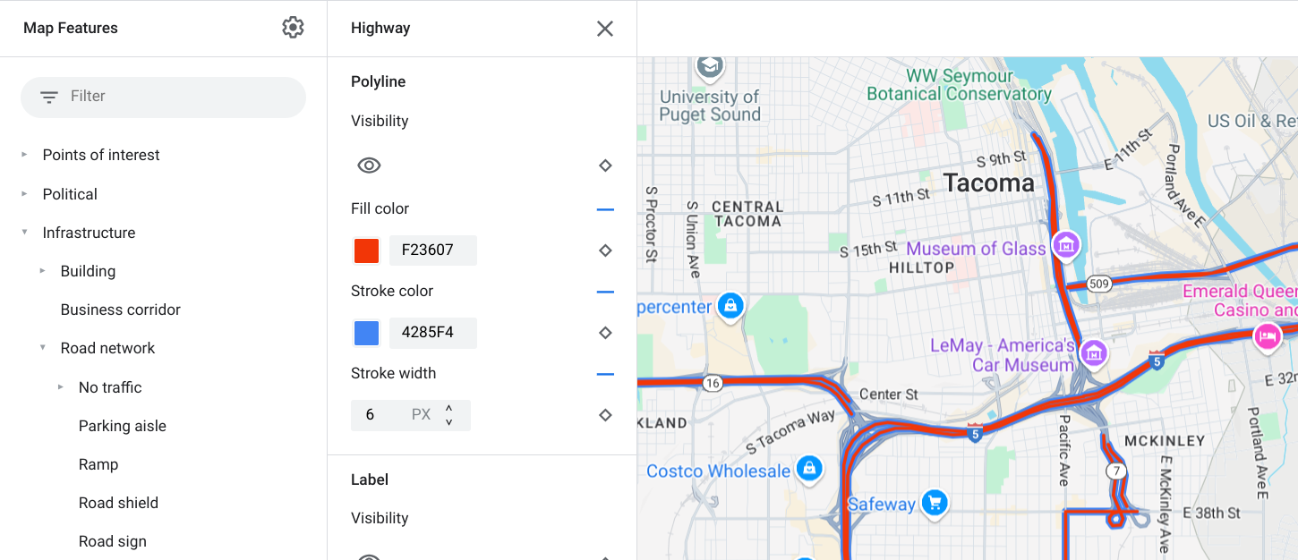
Exemplo de personalização de estilo da polilinha: para o tipo de elemento Rodovia
Rótulos de ícones e texto
Para os tipos de elementos do mapa que são representados de forma total ou parcial por um rótulo, como Pontos de interesse ou Transporte, você pode estilizar os seguintes elementos: Visibilidade, Cor do ícone, Cor de preenchimento do texto e Cor do traço do texto.
Exemplo de personalização do estilo de ícone e texto do rótulo
Hierarquia de elementos do mapa
Estas tabelas dos elementos de mapa de nível superior mostram os elementos secundários disponíveis em cada um deles.
Pontos de interesse
Emergência
Bombeiro
Hospital
Farmácia
Polícia
Entretenimento
Arte
Cassino
Cinema
Local histórico
Museu
Parque temático
Atração turística
Alimentos e bebidas
Bar
Café
Restaurante
Vinícola
Hospedagem
Recreação
Praia
Passeios de barco
Pesca
Campo de golfe
Fonte termal
Reserva natural
Parque
Montanha
Complexo esportivo
Campo esportivo
Início de trilha
Zoológico
Varejo
Supermercado
Shopping
Serviços
Caixa eletrônico
Banco
Locação de veículos
Carregamento de VE
Posto de gasolina
Estacionamento
Correio
Ponto de descanso
Banheiro
Transit
Aeroporto
Outros
Ponte
Cemitério
Governo
Biblioteca
Instalação militar
Local de trabalho
Escola
Praça
[null,null,["Última atualização 2023-12-26 UTC."],[[["\u003cp\u003eCustomize the appearance of Google Maps by styling map features, including their visibility, colors, and outlines.\u003c/p\u003e\n"],["\u003cp\u003eMap features inherit styles from their parent features, but you can override these styles for individual features or zoom levels.\u003c/p\u003e\n"],["\u003cp\u003eChoose to show or hide specific map features using the visibility setting in the style editor.\u003c/p\u003e\n"],["\u003cp\u003eAdjust the styling of shapes and lines, such as polygons and polylines, by changing their fill color, stroke color, and stroke width, although some political features and 3D buildings have limitations.\u003c/p\u003e\n"],["\u003cp\u003eCustomize icons and text labels for points of interest and transportation elements by modifying their colors and outlines.\u003c/p\u003e\n"]]],[],null,["Select platform: [Android](/maps/documentation/android-sdk/cloud-customization/taxonomy \"View this page for the Android platform docs.\") [iOS](/maps/documentation/ios-sdk/cloud-customization/taxonomy \"View this page for the iOS platform docs.\") [JavaScript](/maps/documentation/javascript/cloud-customization/taxonomy \"View this page for the JavaScript platform docs.\") [Web Service](/maps/documentation/maps-static/cloud-customization/taxonomy \"View this page for the Web Service platform docs.\")\n\n\u003cbr /\u003e\n\n\nThe map features you can customize are arranged in a hierarchy, and each map\nfeature has one or more style elements that you can customize. Most top-level\nfeatures have one or more child map features. You have several options when\ncustomizing map styles:\n\n- **Inherit from the base map style**: If you don't customize a style element\n for a map feature, it inherits the default style from the base map.\n\n- **Inherit from parents**: Customize a style element on a parent map feature,\n to have all un-customized child map features below inherit the styles from\n their parent.\n\n- **Override the parent style**: Customize a style element on a child map\n feature to override the parent style for that element.\n\n- **Customize zoom levels** : For some map features, you can customize style\n elements for different zoom levels. For details, see [Style zoom\n levels](/maps/documentation/maps-static/cloud-customization/zoom-levels).\n\nWhat you can style for each map feature\n\nMap features can have one or more of the following style elements that you can\ncustomize, depending on the type of map feature:\n\n- **Visibility**: Whether to show or hide this feature on the map.\n\n- **Fill color**: Fill color for polygons and polylines.\n\n- **Stroke color**: Outline color for polygons and polylines.\n\n- **Stroke width**: Thickness of the outline for polygons and polylines.\n Results may vary depending on the zoom level. If you don't want an outline,\n set the Stroke color to be the same as the Fill color, or set the Stroke\n width to 0.\n\n- **Icon color**: Fill color for the icons.\n\n- **Text fill color**: Fill color for text labels.\n\n- **Text stroke color**: Outline color for text labels.\n\n| **Note:** Stroke color and Stroke width customizations are not available for all map features. For details, see [Polygons and Polylines](#polygons_and_polylines).\n\nMap feature visibility\n\nWhen you hide map features or make them transparent, you may expose boundary\ninaccuracies. Map feature boundaries are not always precise, but are adjusted to\nlook correct when all layers are visible. To learn more about how map layers\naffect each other, see [Manage styles that overlap](/maps/documentation/maps-static/cloud-customization/overlap).\n\nThere are two ways to show or hide map features: visibility and opacity.\n\nVisibility\n\nTo either display or hide a map feature on your map, use the **Visibility**\nstyle element. For more details, see\n[Filter which map features to display](/maps/documentation/maps-static/cloud-customization/viz).\n| **Note:** Not all map features are shown on the map at all zoom levels. To see the map feature displayed or hidden, you may need to zoom in or out.\n\nOpacity\n\nYou can also make a map feature transparent by adjusting the opacity of the\nfollowing style elements: Fill color, Stroke color, Text fill color, and Text\nstroke color. \n\nWhen you adjust the opacity of a map feature, its appearance depends on the map\nfeatures underneath. To avoid unexpected style changes, set a custom style for\nall overlapping features.\n| **Note:** Opacity is not available for all map features.\n\nPolygons and Polylines\n\nFor map feature types that are represented with a shape, such as Beach, Country,\nand Town square, or a line, such as Railway track, Highway, and Trail, you can\ntypically style the following elements: Visibility, Fill color, Stroke color,\nand Stroke width. \n\n*Polygon styling customization example - for **Reservation** feature type*\n\n*Polyline styling customization example - for **Highway** feature type*\n\nStroke color and Stroke width customizations are **not available** for the\nfollowing map features:\n\n- Political map features: Their style conveys meaning on the map, such\n as indicating the type of territory. The political map features are\n **Country** , **Border** , **State or province** , and **Sublocality**.\n\n- 3D style buildings.\n\nIcons and Text Labels\n\nFor map feature types that are fully or partially represented with a label, such\nas Point of interest or Transportation, you can usually style the following\nelements: Visibility, Icon color, Text fill color, and Text stroke color. \n\n*Label text and icon styling customizations example*\n\nMap feature hierarchy\n\nThese tables for the top level map features show what child map features are\navailable under each.\n\n| Point of interest ||\n|----------------|-----------------------------------------------------------------------------------------------------------------|\n| Emergency | Fire Hospital Pharmacy Police |\n| Entertainment | Arts Casino Cinema Historic Museum Theme park Tourist attraction |\n| Food and drink | Bar Cafe Restaurant Winery |\n| Landmark | |\n| Lodging | |\n| Recreation | Beach Boating Fishing Golf course Hot spring Nature reserve Park Peak Sports complex Sports field Trailhead Zoo |\n| Retail | Grocery Shopping |\n| Service | ATM Bank Car rental EV charging Gas station Parking lot Post office Rest stop Restroom |\n| Transit | Airport |\n| Other | Bridge Cemetery Government Library Military Place of worship School Town square |\n\n| Political ||\n|-------------------|---|\n| Country | |\n| Border | |\n| Reservation | |\n| State or province | |\n| City | |\n| Sublocality | |\n| Neighborhood | |\n| Land parcel | |\n\n| Infrastructure ||||\n|-------------------|---------------------|-----------------------------------------|---------------|\n| Building | Commercial | | |\n| Business corridor | | | |\n| Road network | No traffic | Pedestrian mall |\n| Road network | No traffic | Trail | Paved Unpaved |\n| Road network | Parking aisle | | |\n| Road network | Ramp | | |\n| Road network | Road shield | | |\n| Road network | Road sign | | |\n| Road network | Road | Arterial Highway Local No outlet | |\n| Road network | Road detail^\\*^ | Surface Crosswalk Sidewalk Intersection | |\n| Railway track | Commercial Commuter | | |\n| Transit station | Bicycle share | | |\n| Transit station | Bus station | | |\n| Transit station | Ferry terminal | | |\n| Transit station | Funicular station | | |\n| Transit station | Gondola station | | |\n| Transit station | Monorail | | |\n| Transit station | Rail station | Subway station Tram station | |\n| Urban area | | | |\n\n| Natural |||\n|-------------|------------------------|----------------------------------------------|\n| Continent | | |\n| Archipelago | | |\n| Island | | |\n| Land | Land cover^†^ | Crops Dry crops Forest Ice Sand Shrub Tundra |\n| Water | Ocean Lake River Other | |\n| Base | | |"]]