
Maps Static API는 무언가가 바뀔 때 오류 또는 경고를 표시할 수 있습니다. 오답입니다. 이 가이드에서는 각 오류 메시지를 설명하고 오류를 해결하기 위한 추가 안내를 제공합니다.
잘못된 요청
잘못된 요청의 경우 Maps Static API는 HTTP 4xx 상태 코드와 문제를 설명하는 메시지를 반환합니다. 아래는 이러한 오류 상황의 예를 보여줍니다. 참고: 이 목록은 가능한 오류의 전체 목록은 아닙니다. 실제 오류 코드를 확인하세요.
특정 문제에 대한 세부정보를 확인하기 위해 API에서 반환한 메시지를 확인할 수 있습니다.
| 오류 상황의 예 | 상태 코드 |
|---|---|
요청에 잘못된 매개변수가 포함되거나, 필요한 매개변수가 누락되었습니다. 예를 들어 size 매개변수는
숫자 값의 예상 범위이거나 요청에서 누락되었습니다. |
400 BAD REQUEST |
| 요청에 포함된 API 키가 잘못되었습니다. | 403 FORBIDDEN |
지도를 표시할 수 없는 오류
요청은 올바르지만 지도를 표시할 수 없는 또 다른 오류가 발생하면 Maps Static API는 오류에 따라 지도 대신 텍스트나 오류 이미지를 반환합니다. 이러한 오류의 예 애플리케이션이 사용량 제한을 검토하세요.

API 키 및 결제와 관련된 오류
API 키 없이 Maps Static API를 사용하거나 계정에서 결제가 사용 설정되지 않은 경우 페이지에 지도 대신 오류 이미지가 오류 유형을 나타내는 링크와 함께 표시됩니다. 예를 들면 'g.co/staticmaperror/key'입니다.
| 키 없는 오류 및 해결 방법 | |
|---|---|
 |
API 키 없이 Maps Static API를 사용하고 있습니다. 이 문제를 해결하려면 다음 단계를 따르세요.
|
 |
요청에 디지털 서명 (필수)이 없습니다. 이 문제를 해결하려면 URL에 서명하세요. |
경고
일부 오류 조건의 경우 API가 지도를 반환하지만 일부 정보는 지도에서 누락될 수 있습니다. 이 경우 경고를 알려주기 위해 다음과 같은 두 가지 상황이 발생합니다.
- 첫째, 지도가 표시되지만 노란색 오류 막대가 '지도 오류: g.co/staticmaperror' 텍스트가 표시된 지도 위
- 둘째, API는
X-Staticmap-API-Warning라는 HTTP 헤더 형식으로 경고를 반환합니다.
예를 들어 다음 URL은 markers 매개변수에 예상치 못한 값을 포함합니다.
https://maps.googleapis.com/maps/api/staticmap?center=Williamsburg,Brooklyn,NY&zoom=13&scale=1&size=400x400&markers=sdgaags&key=YOUR_API_KEY
API가 지도를 반환하지만 노란색 오류 막대를 중첩하여 표시합니다. 'Map error: g.co/staticmaperror'가 포함된 이미지 위에 표시됩니다.
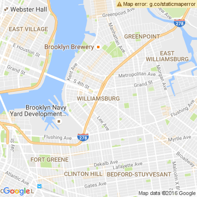
이 API는 또한 다음과 같은 HTTP 헤더를 반환합니다.
X-Staticmap-API-Warning:Error geocoding: marker 1
다음 표에서는 API가 HTTP로 발행할 수 있는 경고에 대해 설명합니다. 헤더:
X-Staticmap-API-Warning 헤더의 경고
|
|
|---|---|
Error geocoding:
[center, ][marker #number, ][visible #num, ][path #num, ]* |
요청을 지오코딩하려는 중에 오류가 발생했습니다. 현재
지오코딩이 지오코딩이 필요한 요소에 따라
실패 (가운데, 마커, 표시 가능 또는 경로) 및 요소 수
확인할 수 있습니다 이 경고의 한 가지 예는 위 예에 표시된 X-Staticmap-API-Warning:Error geocoding: marker 1입니다. |
Too many geocoded markers requested (max is 15). |
요청에서 허용된 최대 수보다 많은 마커를 지정했습니다. 인간이 읽을 수 있는 주소로 전송됩니다. 최대값은 15입니다. 이 한도는 사람이 읽을 수 있는 주소로 지정된 마커에만 적용되며 지오코딩이 필요합니다. 이 제한은 위도/경도 좌표로 지정된 마커에는 적용되지 않습니다. |
Too many geocoded polyline vertices requested (max is 15). |
사람이 읽을 수 있는 주소에서 허용되는 최대 개수를 초과하는 폴리라인이 요청에 지정되었습니다. 최대값은 15입니다. 참고로, 이 제한은 사람이 읽을 수 있는 주소(지오코딩이 필요한 주소)로 지정된 교점이 있는 폴리라인에만 적용됩니다. 인코더-디코더는 위도/경도 좌표입니다. |
HTTP 헤더 경고는 Chrome DevTools 콘솔, Firefox Web Console 또는 브라우저에서 이와 동등한 기타 도구를 사용할 수 있습니다.