science هذا المنتج أو الميزة قيد الاختبار (قبل طرحه للجميع). قد يكون الدعم المقدَّم للمنتجات والميزات في مرحلة ما قبل الإصدار العلني محدودًا، وقد لا تكون التغييرات التي يتم إجراؤها على المنتجات والميزات في مرحلة ما قبل الإصدار العلني متوافقة مع الإصدارات الأخرى من مرحلة ما قبل الإصدار العلني. تخضع "عروض مرحلة ما قبل الإطلاق" للأحكام المحدّدة لخدمة Google Maps Platform. لمزيد من المعلومات، يُرجى الاطّلاع على أوصاف مراحل الإطلاق. الاشتراك لاختبار "إحصاءات الأماكن"
تنظيم صفحاتك في مجموعات
يمكنك حفظ المحتوى وتصنيفه حسب إعداداتك المفضّلة.
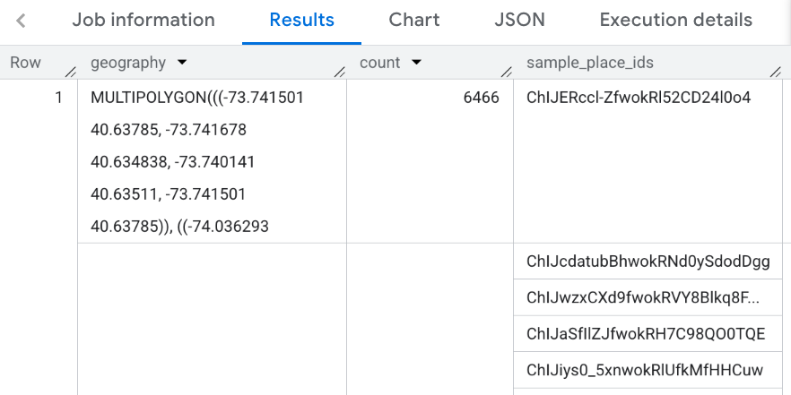
تأخذ الدالة PLACES_COUNT_PER_GEO صفيفًا من المناطق الجغرافية للبحث وتعرض جدولاً يتضمّن عدد الأماكن لكل منطقة. على سبيل المثال، إذا حدّدت مصفوفة من الرموز البريدية كمنطقة البحث، سيتضمّن الردّ جدولاً يتضمّن صفًا منفصلاً لكل رمز بريدي.
بما أنّ الدالة PLACES_COUNT_PER_GEO تعرض جدولاً، استدعِها باستخدام عبارة FROM.
مَعلمات الإدخال:
مطلوبة: geographiesمعلَمة الفلتر التي تحدّد منطقة البحث. تتلقّى المَعلمة
geographies مصفوفة من القيم المحدّدة حسب نوع البيانات
GEOGRAPHY في BigQuery، والذي يتيح استخدام النقاط والخطوط المتعددة والمضلّعات.
جدول يتضمّن صفًا واحدًا لكل منطقة جغرافية يحتوي الجدول على الأعمدة geography (GEOGRAPHY) وcount (INT64) وsample_place_ids (ARRAY<STRING>)، حيث يحتوي sample_place_ids على ما يصل إلى 250 معرّف مكان لكل منطقة جغرافية.
مثال: احتساب عدد المطاعم في كل مقاطعة من مقاطعات مدينة نيويورك
ينشئ هذا المثال جدولاً يتضمّن عدد المطاعم المفتوحة في كل مقاطعة
في مدينة نيويورك.
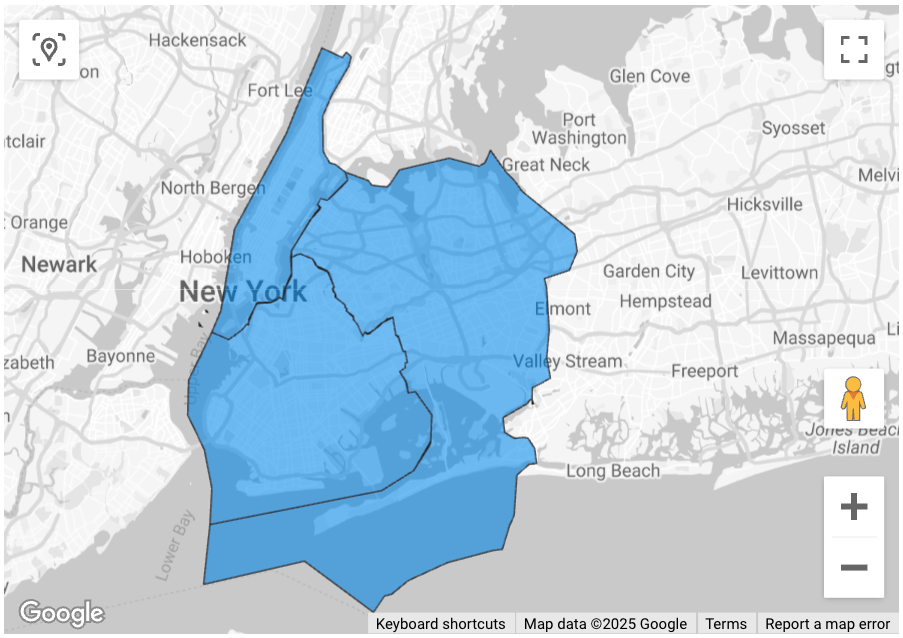
يستخدم هذا المثال بيانات مكتب الإحصاء الأمريكيمجموعة البيانات العامة في BigQuery للحصول على حدود المقاطعات الثلاث في مدينة نيويورك: "كوينز" و"كينغز" و"نيويورك". يتم تضمين حدود كل مقاطعة في العمود county_geom.
يستخدم هذا المثال بعد ذلك الدالة
ST_SIMPLIFY
في BigQuery لعرض نسخة مبسطة من county_geom. تستبدل الدالة ST_SIMPLIFY سلاسل الحواف المستقيمة تقريبًا بحافة طويلة واحدة.
تاريخ التعديل الأخير: 2025-07-17 (حسب التوقيت العالمي المتفَّق عليه)
[null,null,["تاريخ التعديل الأخير: 2025-07-17 (حسب التوقيت العالمي المتفَّق عليه)"],[],[],null,["The `PLACES_COUNT_PER_GEO` function takes an array of geographic areas to search\nand returns a table of places counts per area. For example, if you specify an\narray of zip codes as the search area, the response contains a table with a\nseparate row for each zip code.\n\nBecause the `PLACES_COUNT_PER_GEO` function returns a table, call it using\na `FROM` clause.\n\n- Input parameters:\n\n - **Required** : The `geographies`\n [filter parameter](/maps/documentation/placesinsights/experimental/filter-params) that specifies the search area. The\n `geographies` parameter takes an array of values defined by the BigQuery\n [`GEOGRAPHY`](https://cloud.google.com/bigquery/docs/reference/standard-sql/data-types#geography_type)\n data type, which supports points, linestrings, and polygons.\n\n - **Optional** : Additional [filter](/maps/documentation/placesinsights/experimental/filter-params) parameters to refine your\n search.\n\n- Returns:\n\n - A table with one row per geographic area. The table contains the columns `geography` (`GEOGRAPHY`) and `count` (`INT64`).\n\nExample: Calculate the number of restaurants in each county of New York City\n\nThis example generates a table of counts of operational restaurants per county\nin New York City.\n| **Note:** Because the response table contains a `geographies` field, you can visualize it using tools that support BigQuery `GEOGRAPHY` types. For an example of visualizing the results of a function, see [Visualize\n| results](#visualize_results). For more information and example on visualizing Places Insights results, see [Visualize query results](/maps/documentation/placesinsights/visualize-data).\n\nThis example uses the [United States Census Bureau\nData](https://console.cloud.google.com/marketplace/product/united-states-census-bureau/us-geographic-boundaries)\nBigQuery [public dataset](https://cloud.google.com/bigquery/public-data) to get\nthe boundaries for the three counties in New York City: \"Queens\",\"Kings\", \"New\nYork\". The boundaries of each county are contained in the `county_geom` column.\n\nThis example then uses the BigQuery\n[`ST_SIMPLIFY`](https://cloud.google.com/bigquery/docs/reference/standard-sql/geography_functions#st_simplify)\nfunction to return a simplified version of `county_geom`. The `ST_SIMPLIFY`\nfunction replaces nearly straight chains of edges with a single long edge. \n\n```googlesql\nDECLARE geos ARRAY\u003cGEOGRAPHY\u003e;\n\nSET geos = (SELECT ARRAY_AGG(ST_SIMPLIFY(county_geom, 100))\n FROM `bigquery-public-data.geo_us_boundaries.counties`\n WHERE county_name IN (\"Queens\",\"Kings\", \"New York\") AND state_fips_code = \"36\");\n\nSELECT * FROM `maps-platform-analytics-hub.sample_places_insights_us.PLACES_COUNT_PER_GEO`(\n JSON_OBJECT(\n 'geographies', geos,\n 'types', [\"restaurant\"],\n 'business_status', [\"OPERATIONAL\"]\n )\n);\n```\n\nThe response for the function:\n\nVisualize results\n\nThe following images show this data displayed in Looker Studio as a filled map,\nincluding the outline of each county:\n\nTo import your data into Looker Studio:\n\n1. Run the function above to generate the results.\n\n2. In the BigQuery results, click **Open in -\\\u003e Looker Studio**. Your results\n are automatically imported into Looker Studio.\n\n3. Looker Studio creates a default report page and initializes it with a title,\n table, and bar graph of the results.\n\n4. Select everything on the page and delete it.\n\n5. Click **Insert -\\\u003e Filled map** to add a filled map to your report.\n\n6. Under **Chart types -\\\u003e Setup** configure the fields as shown below::\n\n7. The filled map appears as above. You can optionally select **Chart types -\\\u003e\n Styles** to further configure the appearance of the map.\n\nFor more information and example on visualizing Places Insights results, see\n[Visualize query results](/maps/documentation/placesinsights/visualize-data)."]]