
ডেটা সংগ্রহ করুন
সংগৃহীত অবস্থানের ডেটা পাওয়ার অনেক উপায় আছে। এখানে আমরা Roads API এর 'snap to roads' ফিচারের সাথে ব্যবহার করার জন্য ডেটা সংগ্রহের দুটি কৌশল বর্ণনা করছি।
জিপিএক্স
GPX হলো GPS ডিভাইস দ্বারা ধারণ করা রুট, ট্র্যাক এবং ওয়েপয়েন্ট শেয়ার করার জন্য একটি উন্মুক্ত XML-ভিত্তিক ফরম্যাট। এই উদাহরণটিতে XmlPull পার্সার ব্যবহার করা হয়েছে, যা জাভা সার্ভার এবং মোবাইল উভয় পরিবেশের জন্য উপলব্ধ একটি হালকা XML পার্সার।
/**
 * Parses the waypoint (wpt tags) data into native objects from a GPX stream.
 */
private List<LatLng> loadGpxData(XmlPullParser parser, InputStream gpxIn)
        throws XmlPullParserException, IOException {
    // We use a List<> as we need subList for paging later
    List<LatLng> latLngs = new ArrayList<>();
    parser.setInput(gpxIn, null);
    parser.nextTag();

    while (parser.next() != XmlPullParser.END_DOCUMENT) {
        if (parser.getEventType() != XmlPullParser.START_TAG) {
            continue;
        }

        if (parser.getName().equals("wpt")) {
            // Save the discovered latitude/longitude attributes in each <wpt>.
            latLngs.add(new LatLng(
                    Double.valueOf(parser.getAttributeValue(null, "lat")),
                    Double.valueOf(parser.getAttributeValue(null, "lon"))));
        }
        // Otherwise, skip irrelevant data
    }

    return latLngs;
}
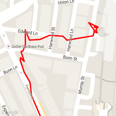
এখানে একটি মানচিত্রে লোড করা কিছু কাঁচা GPX ডেটা রয়েছে।
অ্যান্ড্রয়েড অবস্থান পরিষেবা
আপনার ব্যবহারের ধরনের ওপর নির্ভর করে অ্যান্ড্রয়েড ডিভাইস থেকে জিপিএস ডেটা সংগ্রহ করার সেরা উপায় ভিন্ন হতে পারে। ‘লোকেশন আপডেট গ্রহণ’ বিষয়ক অ্যান্ড্রয়েড প্রশিক্ষণ ক্লাসটি এবং গিটহাবে থাকা গুগল প্লে লোকেশনের নমুনাগুলো দেখে নিন।
দীর্ঘ পথ প্রক্রিয়া করুন
যেহেতু ‘স্ন্যাপ টু রোডস’ ফিচারটি স্বতন্ত্র বিন্দুর পরিবর্তে সম্পূর্ণ পথের উপর ভিত্তি করে অবস্থান অনুমান করে, তাই দীর্ঘ পথ (অর্থাৎ, প্রতি অনুরোধে ১০০-বিন্দুর সীমা অতিক্রমকারী পথ) প্রক্রিয়াকরণের সময় আপনাকে সতর্ক থাকতে হবে।
প্রতিটি অনুরোধকে একটি দীর্ঘ পথ হিসেবে বিবেচনা করার জন্য, আপনার কিছু ওভারল্যাপ রাখা উচিত, যাতে পূর্ববর্তী অনুরোধের শেষ পয়েন্টগুলো পরবর্তী অনুরোধের প্রথম পয়েন্ট হিসেবে অন্তর্ভুক্ত হয়। কতগুলো পয়েন্ট অন্তর্ভুক্ত করতে হবে তা আপনার ডেটার নির্ভুলতার উপর নির্ভর করে। কম নির্ভুলতার অনুরোধগুলোর জন্য আপনার আরও বেশি পয়েন্ট অন্তর্ভুক্ত করা উচিত।
এই উদাহরণটি গুগল ম্যাপস সার্ভিসের জাভা ক্লায়েন্ট ব্যবহার করে পেজড রিকোয়েস্ট পাঠায় এবং তারপর ইন্টারপোলেটেড পয়েন্টসহ ডেটাগুলোকে ফেরত আসা তালিকার সাথে পুনরায় যুক্ত করে।
/**
 * Snaps the points to their most likely position on roads using the Roads API.
 */
private List<SnappedPoint> snapToRoads(GeoApiContext context) throws Exception {
    List<SnappedPoint> snappedPoints = new ArrayList<>();

    int offset = 0;
    while (offset < mCapturedLocations.size()) {
        // Calculate which points to include in this request. We can't exceed the API's
        // maximum and we want to ensure some overlap so the API can infer a good location for
        // the first few points in each request.
        if (offset > 0) {
            offset -= PAGINATION_OVERLAP;   // Rewind to include some previous points.
        }
        int lowerBound = offset;
        int upperBound = Math.min(offset + PAGE_SIZE_LIMIT, mCapturedLocations.size());

        // Get the data we need for this page.
        LatLng[] page = mCapturedLocations
                .subList(lowerBound, upperBound)
                .toArray(new LatLng[upperBound - lowerBound]);

        // Perform the request. Because we have interpolate=true, we will get extra data points
        // between our originally requested path. To ensure we can concatenate these points, we
        // only start adding once we've hit the first new point (that is, skip the overlap).
        SnappedPoint[] points = RoadsApi.snapToRoads(context, true, page).await();
        boolean passedOverlap = false;
        for (SnappedPoint point : points) {
            if (offset == 0 || point.originalIndex >= PAGINATION_OVERLAP - 1) {
                passedOverlap = true;
            }
            if (passedOverlap) {
                snappedPoints.add(point);
            }
        }

        offset = upperBound;
    }

    return snappedPoints;
}
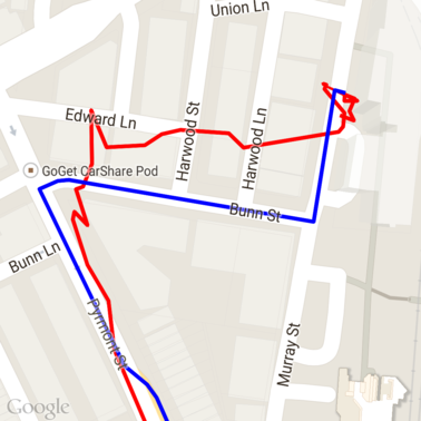
রাস্তাগুলিতে স্ন্যাপ করার অনুরোধগুলি চালানোর পর উপরের ডেটা এখানে দেওয়া হলো। লাল রেখাটি হলো মূল ডেটা এবং নীল রেখাটি হলো স্ন্যাপ করা ডেটা।
কোটার দক্ষ ব্যবহার
রাস্তা তৈরির অনুরোধের জবাবে আপনার দেওয়া পয়েন্টগুলোর সাথে ম্যাপ করা প্লেস আইডিগুলোর একটি তালিকা অন্তর্ভুক্ত থাকে, এবং আপনি interpolate=true সেট করলে এতে অতিরিক্ত পয়েন্টও থাকতে পারে।
গতিসীমার অনুরোধের জন্য আপনার অনুমোদিত কোটার কার্যকর ব্যবহার করতে, আপনার অনুরোধে শুধুমাত্র অনন্য স্থান আইডিগুলির জন্য কোয়েরি করা উচিত। এই উদাহরণটি স্থান আইডিগুলির একটি তালিকা থেকে গতিসীমা কোয়েরি করার জন্য গুগল ম্যাপস সার্ভিসের জাভা ক্লায়েন্ট ব্যবহার করে।
/**
 * Retrieves speed limits for the previously-snapped points. This method is efficient in terms
 * of quota usage as it will only query for unique places.
 *
 * Note: Speed limit data is only available for requests using an API key enabled for a
 * Google Maps APIs Premium Plan license.
 */
private Map<String, SpeedLimit> getSpeedLimits(GeoApiContext context, List<SnappedPoint> points)
        throws Exception {
    Map<String, SpeedLimit> placeSpeeds = new HashMap<>();

    // Pro tip: Save on quota by filtering to unique place IDs.
    for (SnappedPoint point : points) {
        placeSpeeds.put(point.placeId, null);
    }

    String[] uniquePlaceIds =
            placeSpeeds.keySet().toArray(new String[placeSpeeds.keySet().size()]);

    // Loop through the places, one page (API request) at a time.
    for (int i = 0; i < uniquePlaceIds.length; i += PAGE_SIZE_LIMIT) {
        String[] page = Arrays.copyOfRange(uniquePlaceIds, i,
                Math.min(i + PAGE_SIZE_LIMIT, uniquePlaceIds.length));

        // Execute!
        SpeedLimit[] placeLimits = RoadsApi.speedLimits(context, page).await();
        for (SpeedLimit sl : placeLimits) {
            placeSpeeds.put(sl.placeId, sl);
        }
    }

    return placeSpeeds;
}
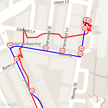
উপরে দেওয়া তথ্যে প্রতিটি স্বতন্ত্র স্থান আইডিতে গতিসীমা চিহ্নিত করা আছে।
অন্যান্য এপিআই-এর সাথে পারস্পরিক ক্রিয়া
'স্ন্যাপ টু রোডস' রেসপন্সে প্লেস আইডি ফেরত আসার একটি সুবিধা হলো, আপনি গুগল ম্যাপস প্ল্যাটফর্মের অনেকগুলো এপিআই-তে সেই প্লেস আইডি ব্যবহার করতে পারেন। এই উদাহরণটিতে, উপরের 'স্ন্যাপ টু রোড' রিকোয়েস্ট থেকে পাওয়া একটি স্থানকে জিওকোড করার জন্য 'জাভা ক্লায়েন্ট ফর গুগল ম্যাপস সার্ভিসেস' ব্যবহার করা হয়েছে।
/**
 * Geocodes a snapped point using the place ID.
 */
private GeocodingResult geocodeSnappedPoint(GeoApiContext context, SnappedPoint point) throws Exception {
    GeocodingResult[] results = GeocodingApi.newRequest(context)
            .place(point.placeId)
            .await();

    if (results.length > 0) {
        return results[0];
    }
    return null;
}
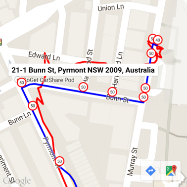
এখানে গতিসীমা নির্দেশকটিকে জিওকোডিং এপিআই থেকে প্রাপ্ত ঠিকানা দিয়ে টীকাযুক্ত করা হয়েছে।
নমুনা কোড
বিবেচ্য বিষয়সমূহ
এই ডকুমেন্টটির সহায়ক কোডটি দৃষ্টান্তমূলক উদ্দেশ্যে একটি একক অ্যান্ড্রয়েড অ্যাপ হিসেবে উপলব্ধ আছে। বাস্তবে, আপনার সার্ভার-সাইড এপিআই কীগুলো কোনো অ্যান্ড্রয়েড অ্যাপে বিতরণ করা উচিত নয়, কারণ এতে আপনার কী কোনো তৃতীয় পক্ষের অননুমোদিত অ্যাক্সেস থেকে সুরক্ষিত রাখা যায় না। এর পরিবর্তে, আপনার কীগুলো সুরক্ষিত করতে, এপিআই-এর সাথে সংযুক্ত কোডটিকে একটি সার্ভার-সাইড প্রক্সি হিসেবে স্থাপন করা উচিত এবং আপনার অ্যান্ড্রয়েড অ্যাপটিকে সেই প্রক্সি ব্যবহার করে অনুরোধ পাঠাতে দেওয়া উচিত, যাতে অনুরোধগুলো অনুমোদিত হয় তা নিশ্চিত করা যায়।
ডাউনলোড করুন
গিটহাব থেকে কোডটি ডাউনলোড করুন।