Fitur peta yang dapat Anda sesuaikan diatur berdasarkan hierarki, dan setiap fitur peta memiliki satu elemen gaya lainnya yang dapat Anda sesuaikan. Sebagian besar fitur
tingkat teratas memiliki satu atau beberapa fitur peta turunan. Anda memiliki beberapa opsi saat
menyesuaikan gaya peta:
Mewarisi dari gaya peta dasar: Jika elemen gaya tidak disesuaikan, fitur peta akan mewarisi gaya default dari peta dasar.
Mewarisi dari induk: Sesuaikan elemen gaya di fitur peta induk, sehingga semua fitur peta turunan yang tidak disesuaikan di bawah mewarisi gaya dari induknya.
Mengganti gaya induk: Sesuaikan elemen gaya di fitur peta turunan untuk mengganti gaya induk untuk elemen tersebut.
Menyesuaikan tingkat zoom: Untuk beberapa fitur peta, Anda dapat menyesuaikan elemen gaya untuk tingkat zoom yang berbeda-beda. Untuk mengetahui detailnya, lihat bagian Mengatur gaya
tingkat zoom.
Penataan gaya yang dapat Anda lakukan untuk setiap fitur peta
Fitur peta dapat memiliki satu atau beberapa elemen gaya berikut yang dapat Anda sesuaikan, bergantung pada jenis fitur petanya:
Warna pengisi: Warna pengisi untuk poligon dan polyline.
Warna goresan: Warna garis batas untuk poligon dan polyline.
Ketebalan goresan: Ketebalan garis batas untuk poligon dan polyline.
Tidak dapat ditetapkan ke 0. Jika Anda tidak menginginkan garis batas, tetapkan Warna goresan
agar sama dengan Warna pengisi.
Warna ikon: Warna pengisi untuk ikon.
Warna pengisi teks: Warna pengisi untuk label teks.
Warna goresan teks: Warna garis batas untuk label teks.
Menampilkan atau menyembunyikan fitur peta
Jika ada fitur peta yang ingin Anda tampilkan atau sembunyikan di peta,
gunakan elemen gaya Visibilitas:
Di editor gaya, pilih fitur peta.
Untuk menampilkan fitur peta: Di bagian Visibility, pilih On. Untuk menghapus fitur peta dari peta: Di bagian Visibility, pilih
Off.
Poligon dan Polyline
Untuk jenis fitur peta yang direpresentasikan dengan bentuk, seperti Pantai, Negara,
dan Alun-alun kota, atau garis, seperti Rel kereta, Jalan raya, dan Jalur, biasanya Anda dapat
menata gaya elemen berikut: Visibilitas, Warna pengisi, Warna goresan, dan Ketebalan
goresan.
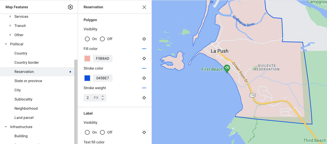
Contoh penyesuaian gaya visual poligon - untuk jenis fitur Reservasi
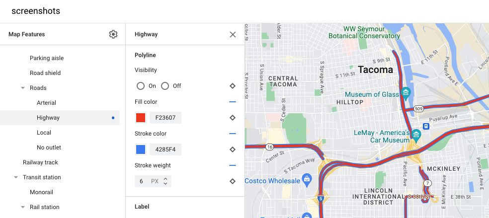
Contoh penyesuaian gaya visual polyline - untuk jenis fitur Jalan raya
Ikon dan Label Teks
Untuk jenis fitur peta yang seluruhnya atau sebagian direpresentasikan dengan label, seperti
Lokasi menarik atau Transportasi, biasanya Anda dapat menata gaya elemen
berikut: Visibilitas, Warna ikon, Warna pengisi teks, dan Warna goresan teks.
Contoh penyesuaian gaya visual ikon dan teks label
Hierarki fitur peta
Tabel berikut menampilkan fitur peta turunan yang tersedia di bawah setiap fitur peta tingkat teratas.
Lokasi menarik
Darurat
Pemadam kebakaran
Rumah sakit
Apotek
Polisi
Hiburan
Seni
Kasino
Bioskop
Historis
Museum
Taman hiburan
Objek wisata
Makanan dan minuman
Bar
Kafe
Restoran
Pabrik anggur
Tempat terkenal
Penginapan
Rekreasi
Pantai
Berlayar
Memancing
Lapangan golf
Mata air panas
Cagar alam
Taman
Puncak
Kompleks olahraga
Lapangan olahraga
Jalan setapak
Kebun binatang
Retail
Bahan makanan
Belanja
Layanan
ATM
Bank
Rental mobil
SPKLU
SPBU
Tempat parkir
Kantor pos
Tempat istirahat
Toilet
Transportasi umum
Bandara
Lainnya
Jembatan
Pemakaman
Pemerintah
Perpustakaan
Militer
Tempat ibadah
Sekolah
Alun-alun kota
Perbatasan politik
Negara
Perbatasan negara
Reservasi
Negara bagian atau provinsi
Kota
Sublokalitas
Kawasan
Persil lahan
Infrastruktur
Bangunan
Aspek Komersial
Koridor bisnis
Jaringan jalan
Tak ada lalu lintas
Mal pejalan kaki
Lintasan
Lorong parkir
Tanjakan
Penanda jalan
Jalan
Arteri
Jalan raya
Lokal
Jalan buntu
Jalur rel kereta api
Stasiun transportasi umum
Rental sepeda
Terminal bus
Terminal feri
Stasiun funicular
Stasiun gondola
Monorel
Stasiun kereta
Stasiun kereta bawah tanah
Stasiun trem
Daerah perkotaan
Alam
Benua
Kepulauan
Pulau
Penutupan lahan
Vegetasi
Lahan pertanian
Pertanian lahan kering
Hutan
Es
Pasir
Semak belukar
Tundra
[null,null,["Terakhir diperbarui pada 2024-06-28 UTC."],[[["\u003cp\u003eMap features are arranged hierarchically, allowing customization by inheriting styles from the base map, parent features, or overriding them for specific features or zoom levels.\u003c/p\u003e\n"],["\u003cp\u003eYou can customize the visibility, fill color, stroke color, stroke width, icon color, text fill color, and text stroke color of various map features.\u003c/p\u003e\n"],["\u003cp\u003eSome features like political boundaries and 3D buildings have limited styling options to maintain their meaning or visual representation.\u003c/p\u003e\n"],["\u003cp\u003eThe platform provides styling options for various categories like points of interest, political boundaries, infrastructure, and natural elements.\u003c/p\u003e\n"],["\u003cp\u003eCustomization options are available for specific elements within each category, for example, under "Points of Interest," you can customize styles for "Emergency," "Entertainment," and other subcategories.\u003c/p\u003e\n"]]],[],null,["# What you can style on the map\n\nSelect platform: [Android](/maps/documentation/android-sdk/cloud-customization/taxonomy \"View this page for the Android platform docs.\") [iOS](/maps/documentation/ios-sdk/cloud-customization/taxonomy \"View this page for the iOS platform docs.\") [JavaScript](/maps/documentation/javascript/cloud-customization/taxonomy \"View this page for the JavaScript platform docs.\") [Web Service](/maps/documentation/maps-static/cloud-customization/taxonomy \"View this page for the Web Service platform docs.\")\n\n\u003cbr /\u003e\n\n\nThe map features you can customize are arranged in a hierarchy, and each map\nfeature has one or more style elements that you can customize. Most top-level\nfeatures have one or more child map features. You have several options when\ncustomizing map styles:\n\n- **Inherit from the base map style**: If you don't customize a style element\n for a map feature, it inherits the default style from the base map.\n\n- **Inherit from parents**: Customize a style element on a parent map feature,\n to have all un-customized child map features below inherit the styles from\n their parent.\n\n- **Override the parent style**: Customize a style element on a child map\n feature to override the parent style for that element.\n\n- **Customize zoom levels** : For some map features, you can customize style\n elements for different zoom levels. For details, see [Style zoom\n levels](/maps/documentation/android-sdk/cloud-customization/zoom-levels).\n\nWhat you can style for each map feature\n---------------------------------------\n\nMap features can have one or more of the following style elements that you can\ncustomize, depending on the type of map feature:\n\n- **Visibility**: Whether to show or hide this feature on the map.\n\n- **Fill color**: Fill color for polygons and polylines.\n\n- **Stroke color**: Outline color for polygons and polylines.\n\n- **Stroke width**: Thickness of the outline for polygons and polylines.\n Results may vary depending on the zoom level. If you don't want an outline,\n set the Stroke color to be the same as the Fill color, or set the Stroke\n width to 0.\n\n- **Icon color**: Fill color for the icons.\n\n- **Text fill color**: Fill color for text labels.\n\n- **Text stroke color**: Outline color for text labels.\n\n| **Note:** Stroke color and Stroke width customizations are not available for all map features. For details, see [Polygons and Polylines](#polygons_and_polylines).\n\n### Map feature visibility\n\nWhen you hide map features or make them transparent, you may expose boundary\ninaccuracies. Map feature boundaries are not always precise, but are adjusted to\nlook correct when all layers are visible. To learn more about how map layers\naffect each other, see [Manage styles that overlap](/maps/documentation/android-sdk/cloud-customization/overlap).\n\nThere are two ways to show or hide map features: visibility and opacity.\n\n#### Visibility\n\nTo either display or hide a map feature on your map, use the **Visibility**\nstyle element. For more details, see\n[Filter which map features to display](/maps/documentation/android-sdk/cloud-customization/viz).\n| **Note:** Not all map features are shown on the map at all zoom levels. To see the map feature displayed or hidden, you may need to zoom in or out.\n\n#### Opacity\n\nYou can also make a map feature transparent by adjusting the opacity of the\nfollowing style elements: Fill color, Stroke color, Text fill color, and Text\nstroke color. \n\nWhen you adjust the opacity of a map feature, its appearance depends on the map\nfeatures underneath. To avoid unexpected style changes, set a custom style for\nall overlapping features.\n| **Note:** Opacity is not available for all map features.\n\n### Polygons and Polylines\n\nFor map feature types that are represented with a shape, such as Beach, Country,\nand Town square, or a line, such as Railway track, Highway, and Trail, you can\ntypically style the following elements: Visibility, Fill color, Stroke color,\nand Stroke width. \n\n*Polygon styling customization example - for **Reservation** feature type*\n\n*Polyline styling customization example - for **Highway** feature type*\n\nStroke color and Stroke width customizations are **not available** for the\nfollowing map features:\n\n- Political map features: Their style conveys meaning on the map, such\n as indicating the type of territory. The political map features are\n **Country** , **Border** , **State or province** , and **Sublocality**.\n\n- 3D style buildings.\n\n### Icons and Text Labels\n\nFor map feature types that are fully or partially represented with a label, such\nas Point of interest or Transportation, you can usually style the following\nelements: Visibility, Icon color, Text fill color, and Text stroke color. \n\n*Label text and icon styling customizations example*\n\nMap feature hierarchy\n---------------------\n\nThese tables for the top level map features show what child map features are\navailable under each.\n\n| ### Point of interest ||\n|----------------|-----------------------------------------------------------------------------------------------------------------|\n| Emergency | Fire Hospital Pharmacy Police |\n| Entertainment | Arts Casino Cinema Historic Museum Theme park Tourist attraction |\n| Food and drink | Bar Cafe Restaurant Winery |\n| Landmark | |\n| Lodging | |\n| Recreation | Beach Boating Fishing Golf course Hot spring Nature reserve Park Peak Sports complex Sports field Trailhead Zoo |\n| Retail | Grocery Shopping |\n| Service | ATM Bank Car rental EV charging Gas station Parking lot Post office Rest stop Restroom |\n| Transit | Airport |\n| Other | Bridge Cemetery Government Library Military Place of worship School Town square |\n\n| ### Political ||\n|-------------------|---|\n| Country | |\n| Border | |\n| Reservation | |\n| State or province | |\n| City | |\n| Sublocality | |\n| Neighborhood | |\n| Land parcel | |\n\n| ### Infrastructure ||||\n|-------------------|---------------------|-----------------------------------------|---------------|\n| Building | Commercial | | |\n| Business corridor | | | |\n| Road network | No traffic | Pedestrian mall |\n| Road network | No traffic | Trail | Paved Unpaved |\n| Road network | Parking aisle | | |\n| Road network | Ramp | | |\n| Road network | Road shield | | |\n| Road network | Road sign | | |\n| Road network | Road | Arterial Highway Local No outlet | |\n| Road network | Road detail^\\*^ | Surface Crosswalk Sidewalk Intersection | |\n| Railway track | Commercial Commuter | | |\n| Transit station | Bicycle share | | |\n| Transit station | Bus station | | |\n| Transit station | Ferry terminal | | |\n| Transit station | Funicular station | | |\n| Transit station | Gondola station | | |\n| Transit station | Monorail | | |\n| Transit station | Rail station | Subway station Tram station | |\n| Urban area | | | |\n\n| ### Natural |||\n|-------------|------------------------|----------------------------------------------|\n| Continent | | |\n| Archipelago | | |\n| Island | | |\n| Land | Land cover^†^ | Crops Dry crops Forest Ice Sand Shrub Tundra |\n| Water | Ocean Lake River Other | |\n| Base | | |"]]