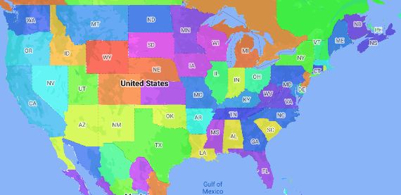
Bản đồ chuyên đề là một loại bản đồ chuyên đề trong đó các khu vực hành chính được tô màu hoặc đổ bóng theo một giá trị dữ liệu. Bạn có thể sử dụng một hàm tạo kiểu để tạo kiểu cho bản đồ dựa trên dữ liệu, trong đó mỗi khu vực hành chính được liên kết với một dải giá trị bằng số. Bản đồ ví dụ sau đây cho thấy một bản đồ chuyên đề cho các tiểu bang của Hoa Kỳ.
Trong ví dụ này, dữ liệu bao gồm mã địa điểm của tiểu bang. Hàm tạo kiểu có điều kiện tô màu từng trạng thái dựa trên giá trị băm của mã địa điểm cho trạng thái.
Nếu bạn chưa thực hiện, hãy làm theo các bước trong phần Bắt đầu để tạo mã bản đồ và kiểu bản đồ mới. Nhớ bật lớp đối tượng Khu vực hành chính cấp 1.
Lấy thông tin tham chiếu đến lớp đối tượng Khu vực hành chính cấp 1 khi bản đồ khởi tạo. Đối với Hoa Kỳ, các cấp hành chính này tương ứng với từng tiểu bang.
Java
privateFeatureLayerareaLevel1Layer; @OverridepublicvoidonMapReady(GoogleMapmap){areaLevel1Layer=map.getFeatureLayer(newFeatureLayerOptions.Builder().featureType(FeatureType.ADMINISTRATIVE_AREA_LEVEL_1).build()); // Apply style factory function to ADMINISTRATIVE_AREA_LEVEL_1 layer.styleAreaLevel1Layer();}
Kotlin
privatevarareaLevel1Layer:FeatureLayer?=null overridefunonMapReady(googleMap:GoogleMap){// Get the ADMINISTRATIVE_AREA_LEVEL_1 feature layer.areaLevel1Layer=googleMap.getFeatureLayer(FeatureLayerOptions.Builder().featureType(FeatureType.ADMINISTRATIVE_AREA_LEVEL_1).build()) // Apply style factory function to ADMINISTRATIVE_AREA_LEVEL_1 layer.styleAreaLevel1Layer()}
Tạo một hàm tạo kiểu và áp dụng hàm đó cho lớp đối tượng Khu vực hành chính cấp 1. Ví dụ sau đây áp dụng hàm cho đa giác đại diện cho từng tiểu bang của Hoa Kỳ.
Java
privatevoidstyleAreaLevel1Layer(){FeatureLayer.StyleFactorystyleFactory=(Featurefeature)->{if(featureinstanceofPlaceFeature){PlaceFeatureplaceFeature=(PlaceFeature)feature; // Return a hueColor in the range [-299,299]. If the value is// negative, add 300 to make the value positive.inthueColor=placeFeature.getPlaceId().hashCode()%300;if(hueColor < 0){hueColor+=300;} returnnewFeatureStyle.Builder()// Set the fill color for the state based on the hashed hue color..fillColor(Color.HSVToColor(150,newfloat[]{hueColor,1,1})).build();}returnnull;}; // Apply the style factory function to the feature layer.areaLevel1Layer.setFeatureStyle(styleFactory);}
Kotlin
privatefunstyleAreaLevel1Layer(){valstyleFactory=FeatureLayer.StyleFactory{feature:Feature->
if(featureisPlaceFeature){valplaceFeature:PlaceFeature=featureasPlaceFeature // Return a hueColor in the range [-299,299]. If the value is// negative, add 300 to make the value positive.varhueColor:Int=placeFeature.getPlaceId().hashCode()%300if(hueColor < 0){hueColor+=300}return@StyleFactoryFeatureStyle.Builder()// Set the fill color for the state based on the hashed hue color..fillColor(Color.HSVToColor(150,floatArrayOf(hueColor.toFloat(),1f,1f))).build()}return@StyleFactorynull} // Apply the style factory function to the feature layer.areaLevel1Layer?.setFeatureStyle(styleFactory)}
[null,null,["Cập nhật lần gần đây nhất: 2025-08-31 UTC."],[[["\u003cp\u003eChoropleth maps use color variations to represent data values associated with geographic areas, like shading states based on population.\u003c/p\u003e\n"],["\u003cp\u003eThis guide explains how to create a choropleth map using a style factory function that colors administrative areas based on data ranges.\u003c/p\u003e\n"],["\u003cp\u003eYou'll learn to enable the "Administrative Area Level 1" feature, access this layer, and apply a style factory function to it, demonstrated with code snippets for Android (Java/Kotlin).\u003c/p\u003e\n"],["\u003cp\u003eThe example provided utilizes a hashed value of the place ID to determine the color of each state, although real-world scenarios would likely involve a lookup table for color assignments.\u003c/p\u003e\n"]]],[],null,["# Make a choropleth map\n\nSelect platform: [Android](/maps/documentation/android-sdk/dds-boundaries/choropleth-map \"View this page for the Android platform docs.\") [iOS](/maps/documentation/ios-sdk/dds-boundaries/choropleth-map \"View this page for the iOS platform docs.\") [JavaScript](/maps/documentation/javascript/dds-boundaries/choropleth-map \"View this page for the JavaScript platform docs.\")\n\n\u003cbr /\u003e\n\nA choropleth map is a type of thematic map in which administrative areas are\ncolored or shaded according to a data value. You can use a style factory\nfunction to style a map based on data where each administrative area is\nassociated with a range of numeric values. The following example map shows a\nchoropleth map for the states of the United States.\n\nIn this example, the data consists of the place ID of the state. The style\nfactory function conditionally colors each state based on a hashed value of the\nplace ID for the state.\n\n| **Note:** Typically, you would define a table of the color for each state, and then lookup the color for each state based on the state's place ID.\n\n1. If you haven't already done so, follow the steps in\n [Get Started](/maps/documentation/android/dds-boundaries/start)\n to create a new map ID and map style. Be sure to enable the\n **Administrative Area Level 1** feature layer.\n\n2. Get a reference to the Administrative Area Level 1 feature layer when the\n map initializes. For the United States, these administrative levels\n correspond to the individual states.\n\n ### Java\n\n\n ```java\n private FeatureLayer areaLevel1Layer;\n\n @Override\n public void onMapReady(GoogleMap map) {\n areaLevel1Layer = map.getFeatureLayer(new FeatureLayerOptions.Builder()\n .featureType(FeatureType.ADMINISTRATIVE_AREA_LEVEL_1)\n .build());\n\n // Apply style factory function to ADMINISTRATIVE_AREA_LEVEL_1 layer.\n styleAreaLevel1Layer();\n }\n ```\n\n \u003cbr /\u003e\n\n ### Kotlin\n\n\n ```java\n private var areaLevel1Layer: FeatureLayer? = null\n\n override fun onMapReady(googleMap: GoogleMap) {\n // Get the ADMINISTRATIVE_AREA_LEVEL_1 feature layer.\n areaLevel1Layer = googleMap.getFeatureLayer(FeatureLayerOptions.Builder()\n .featureType(FeatureType.ADMINISTRATIVE_AREA_LEVEL_1)\n .build())\n\n // Apply style factory function to ADMINISTRATIVE_AREA_LEVEL_1 layer.\n styleAreaLevel1Layer()\n }\n ```\n\n \u003cbr /\u003e\n\n3. Create a style factory function and apply it to the\n Administrative Area Level 1 feature layer. The following example applies the\n function to the polygon representing each state of the United States.\n\n ### Java\n\n\n ```java\n private void styleAreaLevel1Layer() {\n FeatureLayer.StyleFactory styleFactory = (Feature feature) -\u003e {\n if (feature instanceof PlaceFeature) {\n PlaceFeature placeFeature = (PlaceFeature) feature;\n\n // Return a hueColor in the range [-299,299]. If the value is\n // negative, add 300 to make the value positive.\n int hueColor = placeFeature.getPlaceId().hashCode() % 300;\n if (hueColor \u003c 0) {\n hueColor += 300;\n }\n\n return new FeatureStyle.Builder()\n // Set the fill color for the state based on the hashed hue color.\n .fillColor(Color.HSVToColor(150, new float[] {hueColor, 1, 1}))\n .build();\n }\n return null;\n };\n\n // Apply the style factory function to the feature layer.\n areaLevel1Layer.setFeatureStyle(styleFactory);\n }\n ```\n\n \u003cbr /\u003e\n\n ### Kotlin\n\n\n ```java\n private fun styleAreaLevel1Layer() {\n val styleFactory = FeatureLayer.StyleFactory { feature: Feature -\u003e\n if (feature is PlaceFeature) {\n val placeFeature: PlaceFeature = feature as PlaceFeature\n\n // Return a hueColor in the range [-299,299]. If the value is\n // negative, add 300 to make the value positive.\n var hueColor: Int = placeFeature.getPlaceId().hashCode() % 300\n if (hueColor \u003c 0) {\n hueColor += 300\n }\n return@StyleFactory FeatureStyle.Builder()\n // Set the fill color for the state based on the hashed hue color.\n .fillColor(Color.HSVToColor(150, floatArrayOf(hueColor.toFloat(), 1f, 1f)))\n .build()\n }\n return@StyleFactory null\n }\n\n // Apply the style factory function to the feature layer.\n areaLevel1Layer?.setFeatureStyle(styleFactory)\n }\n ```\n\n \u003cbr /\u003e"]]