Google uses AI technology to translate content into your preferred language. AI translations can contain errors.
Maps SDK สําหรับไลบรารียูทิลิตีของ Android
จัดทุกอย่างให้เป็นระเบียบอยู่เสมอด้วยคอลเล็กชัน
บันทึกและจัดหมวดหมู่เนื้อหาตามค่ากำหนดของคุณ
เลือกแพลตฟอร์ม
Android
iOS
หากกำลังมองหาฟีเจอร์ขั้นสูงที่จะเพิ่มลงในแผนที่ ไลบรารียูทิลิตี Maps SDK สำหรับ Android เป็นไลบรารีคลาสแบบโอเพนซอร์สที่มีประโยชน์สําหรับแอปพลิเคชันต่างๆ ที่เก็บ GitHub มีคลาสยูทิลิตีและแอปเดโม ที่แสดงการใช้แต่ละคลาส
ในวิดีโอนี้ Chris Broadfoot จะพูดถึงคลังยูทิลิตี โดยเน้นไปที่การถอดรหัสรูปหลายเส้น เรขาคณิตทรงกลม และไอคอนฟอง
การตั้งค่าอย่างรวดเร็ว
หากต้องการติดตั้งไลบรารียูทิลิตี Maps SDK สำหรับ Android ให้ทําตามคู่มือการตั้งค่า
ยูทิลิตี
นําเข้า GeoJSON ไปยังแผนที่
คุณสามารถจัดเก็บองค์ประกอบในรูปแบบ GeoJSON และใช้ยูทิลิตีนี้เพื่อแสดงผลเป็นเลเยอร์บนแผนที่
เรียกใช้ addLayer() เพื่อเพิ่มข้อมูล GeoJSON ลงในแผนที่
นอกจากนี้ คุณยังเพิ่มฟีเจอร์แต่ละรายการได้โดยเรียกใช้ addFeature() โดยส่งออบเจ็กต์ GeoJsonFeature
โปรดดูรายละเอียดในเอกสารประกอบเกี่ยวกับยูทิลิตี GeoJSON ของ Android ของ Google Maps
นําเข้า KML ไปยังแผนที่
เมื่อใช้ยูทิลิตีนี้ คุณจะแปลงออบเจ็กต์ KML เป็นรูปร่างทางภูมิศาสตร์และแสดงผลเป็นเลเยอร์บนแผนที่ได้ โทรหา addLayerToMap() เพื่อเพิ่มเลเยอร์ลงในแผนที่ คุณสามารถเข้าถึงพร็อพเพอร์ตี้ในออบเจ็กต์ KML ได้โดยเรียกใช้ getProperties() ใน Placemark, GroundOverlay, เอกสาร หรือโฟลเดอร์
โปรดดูรายละเอียดในเอกสารประกอบเกี่ยวกับ Google Maps ยูทิลิตี KML ของ Android
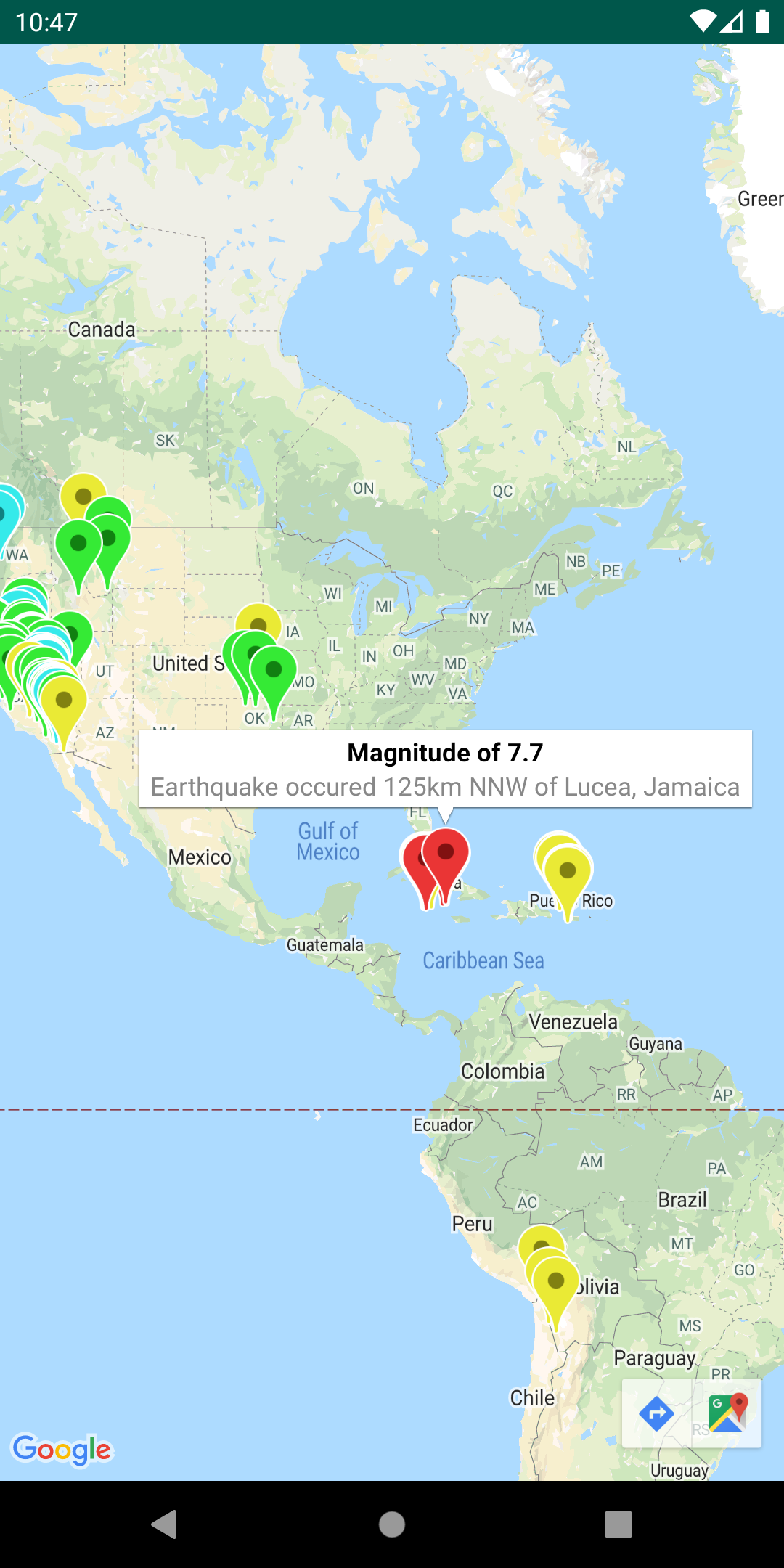
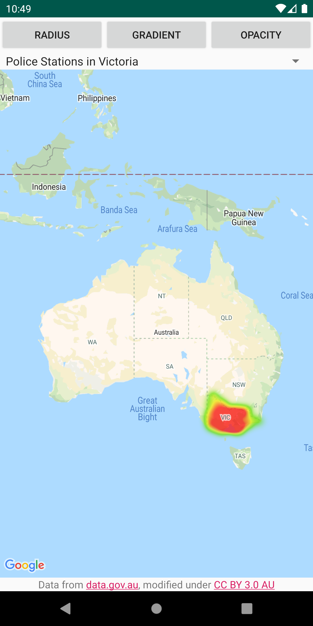
เพิ่มแผนที่ความร้อนลงในแผนที่
แผนที่ความร้อนช่วยให้ผู้ชมเข้าใจการกระจายและความเข้มสัมพัทธ์ของจุดข้อมูลบนแผนที่ได้ง่าย แผนที่ความร้อนจะใช้สีและรูปร่างเพื่อแสดงการกระจายตัวของข้อมูลแทนการวางเครื่องหมายในแต่ละตำแหน่ง สร้าง HeatmapTileProvider โดยส่งคอลเล็กชันออบเจ็กต์ LatLng ที่แสดงจุดที่น่าสนใจบนแผนที่ จากนั้นสร้าง TileOverlay
โปรดดูรายละเอียดในเอกสารประกอบเกี่ยวกับยูทิลิตีแผนที่ความร้อนของ Android ใน Google Maps
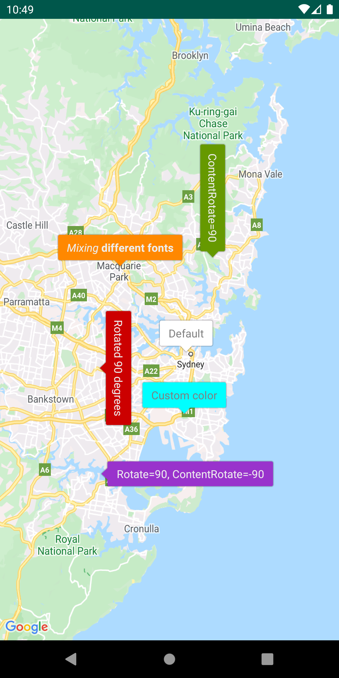
ปรับแต่งเครื่องหมายผ่านไอคอนลูกโป่ง
เพิ่ม IconGenerator เพื่อแสดงข้อมูลสั้นๆ ในเครื่องหมาย ยูทิลิตีนี้ช่วยให้ไอคอนเครื่องหมายมีลักษณะคล้ายกับหน้าต่างข้อมูลได้ เนื่องจากเครื่องหมายเองอาจมีข้อความและเนื้อหาอื่นๆ ข้อดีคือคุณสามารถเปิดเครื่องหมายได้มากกว่า 1 เครื่องพร้อมกัน แต่เปิดหน้าต่างข้อมูลได้เพียงครั้งละ 1 หน้าต่าง
นอกจากนี้ คุณยังจัดรูปแบบเครื่องหมาย เปลี่ยนการวางแนวของเครื่องหมายและ/หรือเนื้อหา รวมถึงเปลี่ยนรูปภาพพื้นหลัง/Nine-Patch ของเครื่องหมายได้ด้วย
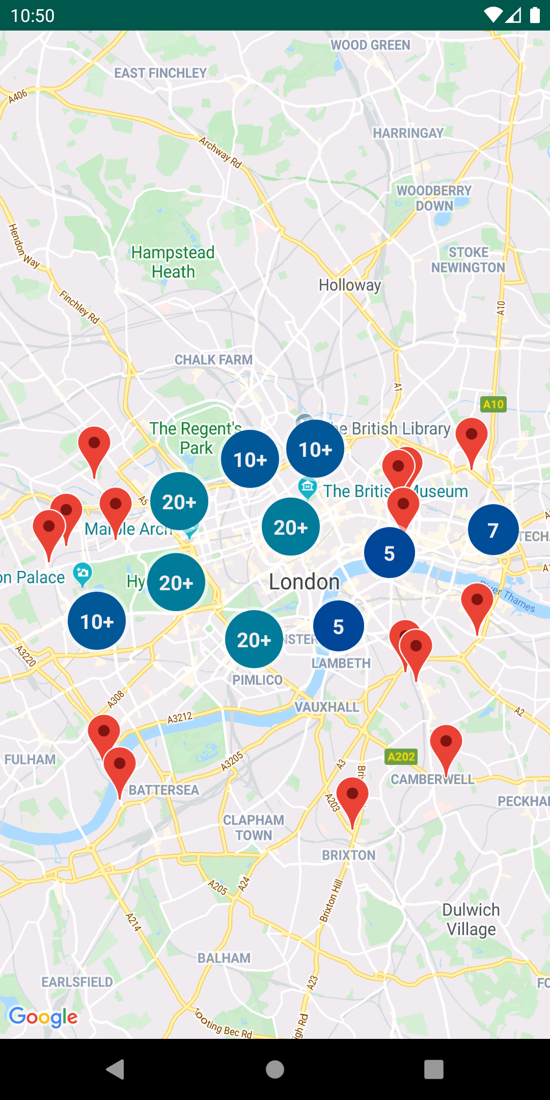
จัดการคลัสเตอร์เครื่องหมาย
ClusterManager ช่วยให้คุณจัดการเครื่องหมายหลายรายการในระดับการซูมต่างๆ ได้ ซึ่งหมายความว่าคุณสามารถวางเครื่องหมายจำนวนมากบนแผนที่ได้โดยไม่ทำให้อ่านแผนที่ได้ยาก เมื่อผู้ใช้ดูแผนที่ในระดับการซูมสูง เครื่องหมายแต่ละรายการจะแสดงบนแผนที่ เมื่อผู้ใช้ซูมออกไปยังระดับการซูมต่ำลง เครื่องหมายจะรวมกันเป็นกลุ่มเพื่อให้ดูแผนที่ได้ง่ายขึ้น
โปรดดูรายละเอียดในเอกสารประกอบเกี่ยวกับยูทิลิตีการจัดกลุ่มเครื่องหมายของ Google Maps สำหรับ Android
เพิ่มเลเยอร์หลายรายการลงในแผนที่เดียวกัน
คุณสามารถแสดงองค์ประกอบจาก GeoJSON, KML และคลัสเตอร์ รวมถึงเครื่องหมาย เส้นประกอบ และรูปหลายเหลี่ยมของคุณเองทั้งหมดในแผนที่เดียวกัน นอกจากนี้ คุณยังทําให้เลเยอร์เหล่านี้เป็นแบบอินเทอร์แอกทีฟได้ด้วยการเพิ่มตัวรับฟังการคลิกลงในเลเยอร์แต่ละเลเยอร์
เพียงสร้างอินสแตนซ์ของคลาส MarkerManager, GroundOverlayManager,
PolygonManager และ PolylineManager แล้วส่งผ่านไปยังคอนสตรคเตอร์ของ GeoJsonLayer, KmlLayer และ ClusterManager เมื่อตั้งค่า จากนั้นคุณก็สามารถใช้คลาส Manager ข้างต้นได้โดยตรงเพื่อเพิ่มเครื่องหมาย เส้นประกอบ และรูปหลายเหลี่ยมของคุณเองลงในแผนที่
โปรดดูรายละเอียดในเอกสารประกอบ เกี่ยวกับ Google Maps Multi Layer Demo บน Android
เข้ารหัสและถอดรหัสเส้นประกอบ
PolyUtil มีประโยชน์สำหรับการแปลงรูปหลายเหลี่ยมและรูปหลายเหลี่ยมที่เข้ารหัสเป็นพิกัดละติจูด/ลองจิจูด และในทางกลับกัน
ใน Google Maps พิกัดละติจูดและลองจิจูดที่กําหนดเส้นประกอบหรือรูปหลายเหลี่ยมจะจัดเก็บเป็นสตริงที่เข้ารหัส ดูคำอธิบายโดยละเอียดเกี่ยวกับการเข้ารหัส Polyline คุณอาจได้รับสตริงที่เข้ารหัสนี้ในการตอบกลับจาก Google API เช่น Directions API (เดิม)
คุณสามารถใช้ PolyUtil ในไลบรารียูทิลิตี Maps SDK สําหรับ Android เพื่อเข้ารหัสลําดับพิกัดละติจูด/ลองจิจูด ("LatLngs") เป็นสตริงเส้นทางที่เข้ารหัส และเพื่อถอดรหัสสตริงเส้นทางที่เข้ารหัสเป็นลําดับ LatLngs ซึ่งจะช่วยให้มั่นใจได้ว่าเว็บเซอร์วิสของ Google Maps API จะทำงานร่วมกันได้
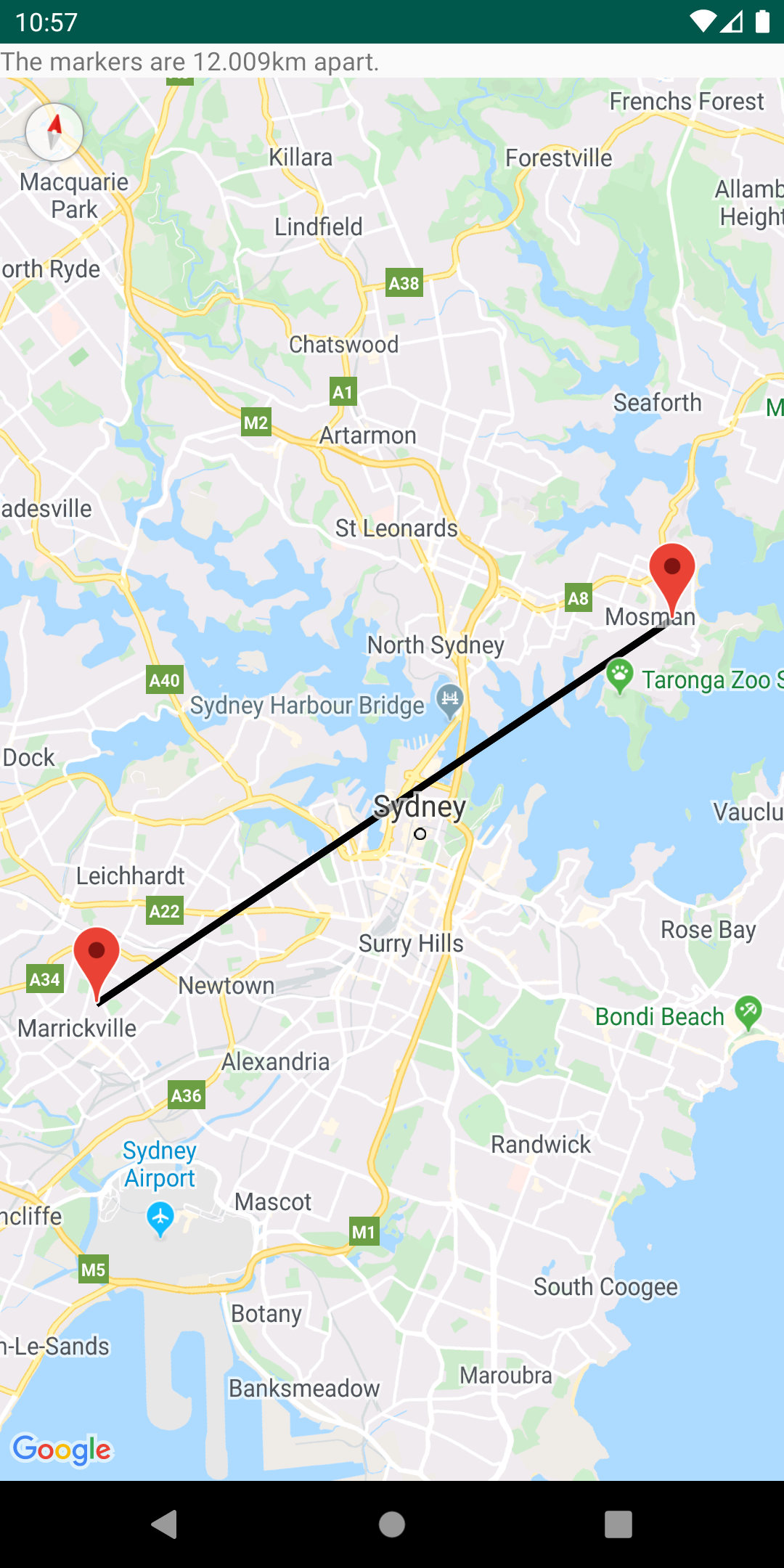
คำนวณระยะทาง พื้นที่ และทิศทางผ่านเรขาคณิตทรงกลม
การใช้ยูทิลิตีเรขาคณิตทรงกลมใน SphericalUtil จะช่วยให้คุณคํานวณระยะทาง พื้นที่ และทิศทางตามละติจูดและลองจิจูดได้ ตัวอย่างวิธีการที่มีให้ใช้งานในยูทิลิตีมีดังนี้
computeDistanceBetween() – แสดงผลระยะทางเป็นเมตรระหว่างพิกัดละติจูด/ลองจิจูด 2 รายการcomputeHeading() – แสดงผลทิศทางเป็นองศาระหว่างพิกัดละติจูด/ลองจิจูด 2 รายการcomputeArea() – แสดงผลพื้นที่ของเส้นทางปิดบนโลกเป็นตารางเมตรinterpolate() – แสดงผลพิกัดละติจูด/ลองจิจูดของจุดที่อยู่ห่างจากจุดหนึ่งๆ ที่กำหนดเป็นเศษส่วนของระยะทางระหว่างจุด 2 จุดที่กำหนด คุณสามารถใช้คำสั่งนี้เพื่อทำให้เครื่องหมายเคลื่อนไหวระหว่าง 2 จุดได้ เป็นต้น
ดูรายการวิธีการทั้งหมดในยูทิลิตีได้จากเอกสารอ้างอิง
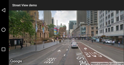
ตรวจสอบว่า Street View รองรับสถานที่หรือไม่
คลาส StreetViewUtil มีฟังก์ชันการทำงานเพื่อตรวจสอบว่า Street View รองรับสถานที่หรือไม่ คุณหลีกเลี่ยงข้อผิดพลาดเมื่อเพิ่มภาพพาโนรามาของ Street View ลงในแอป Android ได้โดยเรียกใช้ยูทิลิตีข้อมูลเมตานี้ และเพิ่มภาพพาโนรามาของ Street View เฉพาะในกรณีที่การตอบกลับคือ OK
ดูรายละเอียดได้ในเอกสารประกอบเกี่ยวกับยูทิลิตีข้อมูลเมตาของ Street View ใน GitHub
เนื้อหาของหน้าเว็บนี้ได้รับอนุญาตภายใต้ใบอนุญาตที่ต้องระบุที่มาของครีเอทีฟคอมมอนส์ 4.0 และตัวอย่างโค้ดได้รับอนุญาตภายใต้ใบอนุญาต Apache 2.0 เว้นแต่จะระบุไว้เป็นอย่างอื่น โปรดดูรายละเอียดที่นโยบายเว็บไซต์ Google Developers Java เป็นเครื่องหมายการค้าจดทะเบียนของ Oracle และ/หรือบริษัทในเครือ
อัปเดตล่าสุด 2026-06-19 UTC
[null,null,["อัปเดตล่าสุด 2026-06-19 UTC"],[],["The Maps SDK for Android Utility Library offers tools for enhancing map functionality. Key actions include importing GeoJSON and KML data, adding heatmaps, managing marker clusters, and customizing markers with bubble icons. It supports adding multiple layers, and it also allows users to encode/decode polylines and utilize spherical geometry for distance, area, and heading calculations. Additionally, users can check if a location is supported in street view. All utilities are open-source, and can be viewed with the provided demo app.\n"]]