Organiza tus páginas con colecciones
Guarda y categoriza el contenido según tus preferencias.
Desarrolladores del Espacio Económico Europeo (EEE)
El extremo dataLayers devuelve datos codificados como archivos GeoTIFF, que se pueden usar en cualquier aplicación de sistema de información geográfica (SIG) para diseñar sistemas solares.
Cada cadena de la respuesta de dataLayers contiene una URL que puedes usar para recuperar el archivo GeoTIFF correspondiente. Las URLs son válidas hasta una hora después de que se generan a partir de la solicitud original de la capa de datos. Los archivos GeoTIFF se pueden almacenar durante un máximo de 30 días.
Con la excepción de la capa RGB, los archivos GeoTIFF no se muestran correctamente con un visor de imágenes, ya que el contenido son datos codificados en lugar de imágenes RGB. Los archivos GeoTIFF tampoco se pueden usar directamente como una imagen de superposición con la API de Maps JavaScript.
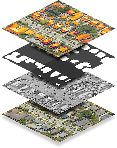
En la siguiente tabla, se describe cada capa en detalle.
Capa
Profundidad de píxeles
Solución
Descripción
Modelo digital de superficie (DSM)
Número de punto flotante de 32 bits
0.1 m/píxel
Son los datos de elevación que representan la topografía de la superficie de la Tierra, incluidas las características naturales y las construidas. Los valores están en metros sobre el nivel del mar. Las ubicaciones no válidas o las áreas en las que no tenemos datos se almacenan como -9999.
RGB
De 8 bits
0.1 m/píxel 0.25 m/píxel 0.5 m/píxel 1 m/píxel
Es una imagen aérea de la región. El archivo de imágenes GeoTIFF contiene tres bandas que corresponden a los valores de rojo, verde y azul para formar un valor RGB de 24 bits para cada píxel.
De forma predeterminada, la resolución de píxeles es de 0.1 m/píxel.
Máscara de compilación
1 bit
0.1 m/píxel
Un bit por píxel que indica si ese píxel se considera parte de un techo.
Flujo anual
Número de punto flotante de 32 bits
0.1 m/píxel
Mapa de flujo anual, o luz solar anual en los techos, de la región.
Los valores son kWh/kW/año.
El flujo se calcula para cada ubicación, no solo para los techos de los edificios. Las ubicaciones no válidas o las áreas en las que no pudimos calcular el flujo se almacenan como -9999. Las ubicaciones fuera de nuestra área de cobertura no son válidas.
Nota: Este es el flujo sin máscara.
Flujo mensual
Número de punto flotante de 32 bits
0.5 m/píxel
Es el mapa de flujo mensual (luz solar en los techos, desglosado por mes) de la región. Los valores son kWh/kW/año. El archivo de imágenes GeoTIFF contiene 12 bandas correspondientes a los meses de enero a diciembre, en orden.
Sombra por hora
Número entero de 32 bits
1 m/píxel
12 URLs para los mapas de sombra por hora correspondientes a los meses de enero a diciembre, en orden.
Cada archivo GeoTIFF contiene 24 bandas, que corresponden a las
24 horas del día. Cada píxel es un número entero de 32 bits que corresponde a los (hasta) 31 días de ese mes. Un 1 bit significa que la ubicación correspondiente puede ver el sol ese día, a esa hora y en ese mes.
Las ubicaciones no válidas se almacenan como -9999 y tienen el bit 31 establecido, ya que corresponde al día 32 del mes y, por lo tanto, no es válido.
Decodifica rásteres de sombra por hora
Los datos de sombra por hora se codifican en rásteres multibanda. Para obtener más información sobre los conceptos básicos de los rásteres, consulta Conceptos de la API de Solar.
Cuando realizas una solicitud de datos de sombra por hora, puedes recibir hasta 12 rásteres, uno para cada mes del año calendario (de enero a diciembre). Cada ráster se compone de 24 capas o bandas, que corresponden a las 24 horas del día.
Cada banda se representa con una matriz de celdas o píxeles. Cada píxel tiene una profundidad de 32 bits, que corresponden a los 31 días (máximo) del mes.
Por lo tanto, para decodificar el día, la hora y el mes de los datos de sombra, es necesario comprender el bit, la banda y el ráster que se analizan.
Por ejemplo, para identificar si una ubicación determinada en las coordenadas (x, y) vio el sol a las 4 p.m. del 22 de junio, haz lo siguiente:
Realiza una solicitud de capas de datos para todas las capas de la ubicación (x, y).
Como junio es el sexto mes del año, recupera la sexta URL de la lista hourlyShadeUrls.
Los intervalos horarios se indican en formato de 24 horas. Para obtener datos de las 4 p.m. (16:00), busca el canal 17.
Índice de bits (días) a partir de 0. Para obtener los datos del 22º día de junio, lee el bit 21.
Los bits proporcionan datos binarios que indican si esa ubicación vio el sol en la fecha y hora determinadas. Si el bit es 1, significa que la ubicación vio el sol. Si el bit es 0, la ubicación vio sombra.
[null,null,["Última actualización: 2025-08-27 (UTC)"],[[["\u003cp\u003eThe dataLayers endpoint provides access to various geographical data layers like elevation, aerial imagery, and solar potential, encoded in GeoTIFF format for use in GIS applications.\u003c/p\u003e\n"],["\u003cp\u003eGeoTIFF URLs are valid for one hour and the downloaded files can be stored for up to 30 days, with most layers requiring specialized software for proper visualization due to data encoding.\u003c/p\u003e\n"],["\u003cp\u003eThe hourly shade layer is encoded to indicate sun exposure for each location at a specific time and day of the month, requiring bitwise operations to decode the information.\u003c/p\u003e\n"],["\u003cp\u003eThe hourly shade data uses the location's regional time zone, assumes no leap days or daylight savings, and treats all days as 24 hours long with standard time noon.\u003c/p\u003e\n"]]],["The `dataLayers` endpoint provides GeoTIFF files for solar system design, accessible via URLs valid for one hour, and storable for 30 days. These files include: Digital Surface Model (DSM) for elevation; RGB imagery; Building mask indicating rooftop pixels; Annual flux showing annual sunlight; Monthly flux with sunlight data per month and hourly shade containing 12 rasters, with 24 layers for each hour of the day each month, each one represented by bits indicating whether the location saw the sun on a given day, hour and month.\n"],null,["# About GeoTIFF files\n\n**European Economic Area (EEA) developers** If your billing address is in the European Economic Area, effective on 8 July 2025, the [Google\n| Maps Platform EEA Terms of Service](https://cloud.google.com/terms/maps-platform/eea) will apply to your use of the Services. [Learn more](/maps/comms/eea/faq). In addition, certain content from the Solar API will no longer be returned. [Learn more](/maps/comms/eea/solar).\n\nThe [dataLayers](/maps/documentation/solar/data-layers) endpoint\nreturns data encoded as GeoTIFF files, which can be used in any geographic\ninformation system (GIS) application to design solar systems.\n\nEach string in the dataLayers response contains a URL, which you can\nuse to fetch the corresponding GeoTIFF. URLs are valid for up to an hour after\nthey are generated from the original data layers request. GeoTIFF files can be\nstored for up to 30 days.\n\nWith the exception of the RGB layer, GeoTIFF files don't display correctly with\nan image viewer, as the content is encoded data rather than RGB images. GeoTIFF\nfiles also cannot be used directly as an overlay image with Maps Javascript API.\n\nThe following table describes each layer in detail.\n\n| Layer | Pixel depth | Resolution | Description |\n|-----------------------------|----------------|------------------------------------------------|---------------------------------------------------------------------------------------------------------------------------------------------------------------------------------------------------------------------------------------------------------------------------------------------------------------------------------------------------------------------------------------------------------------------------------------------------------------------------------------------------------------|\n| Digital Surface Model (DSM) | 32-bit float | 0.1 m/pixel | Elevation data that represents the topography of Earth's surface, including natural and built features. Values are in meters above sea level. Invalid locations, or areas where we don't have data, are stored as -9999. |\n| RGB | 8-bit | 0.1 m/pixel 0.25 m/pixel 0.5 m/pixel 1 m/pixel | An aerial image of the region. The GeoTIFF imagery file contains three bands corresponding to red, green and blue values in order to form 24-bit RGB value for each pixel. By default, the pixel resolution is 0.1 m/pixel. |\n| Building mask | 1-bit | 0.1 m/pixel | One bit per pixel indicating whether that pixel is considered to be part of a rooftop. |\n| Annual flux | 32-bit float | 0.1 m/pixel | The annual flux map, or annual sunlight on roofs, of the region. Values are kWh/kW/year. Flux is computed for every location, not just building rooftops. Invalid locations, or areas where we couldn't calculate flux, are stored as -9999. Locations outside our [coverage area](/maps/documentation/solar/coverage) are invalid. **Note:** This is unmasked flux. |\n| Monthly flux | 32-bit float | 0.5 m/pixel | The monthly flux map (sunlight on roofs, broken down by month) of the region. Values are kWh/kW/year. The GeoTIFF imagery file contains 12 bands corresponding to January --- December, in order. |\n| Hourly shade | 32-bit integer | 1 m/pixel | 12 URLs for hourly shade maps corresponding to January --- December, in order. Each GeoTIFF file contains 24 bands, corresponding to the 24 hours of the day. Each pixel is a 32 bit integer, corresponding to the (up to) 31 days of that month. A 1 bit means that the corresponding location is able to see the sun on that day, at that hour, in that month. \u003cbr /\u003e Invalid locations are stored as -9999 and have bit 31 set, as that corresponds to the 32nd day of the month and is therefore invalid. |\n\nDecode hourly shade rasters\n---------------------------\n\nHourly shade data is encoded in multiband rasters. To learn more about raster\nbasics, see [Solar API Concepts](/maps/documentation/solar/concepts).\n\nWhen you make a request for hourly shade data, you can receive up to 12 rasters,\none for each month of the calendar year (January through December). Each raster\nis composed of 24 layers, or *bands*, which correspond to the 24 hours of the\nday.\n\nEach band is represented by a matrix of cells, or *pixels*. Each pixel has a\ndepth of 32 bits, which correspond to the (maximum) 31 days of the month.\nDecoding the day, time, and month of shade data, therefore, requires\nunderstanding the bit, band, and raster that you are analyzing.\n\nFor example, to identify whether a given location at coordinates (x, y) saw the\nsun at 4:00 PM on June 22, do the following:\n\n1. Make a data layers request for all layers for location (x, y).\n2. Because the month of June is the sixth month of the year, fetch the sixth URL in the `hourlyShadeUrls` list.\n3. Hourly bands are given in 24-hour time. To get data for 4:00 PM (16:00), look up the 17th channel.\n4. Bits (days) index from 0. To get data for the 22nd day of June, read bit 21.\n5. Bits provide binary data indicating whether that location saw sun at the given date and time. If the bit is 1, the location saw sun. If the bit is 0, the location saw shade.\n\nThe following code summarizes the steps above: \n\n```transact-sql\n(hourly_shade[month - 1])(x, y)[hour] & (1 \u003c\u003c (day - 1))\n```\n| **Note:** Hourly shade data is based on the regional time zone of the requested location. Hourly shade data also assumes that there are no leap days and that Daylight Savings Time does not exist. All days are assumed to be 24 hours long and noon is always \"standard time\" noon (12:00)."]]