Sử dụng bộ sưu tập để sắp xếp ngăn nắp các trang
Lưu và phân loại nội dung dựa trên lựa chọn ưu tiên của bạn.
Nhà phát triển ở Khu vực kinh tế Châu Âu (EEA)
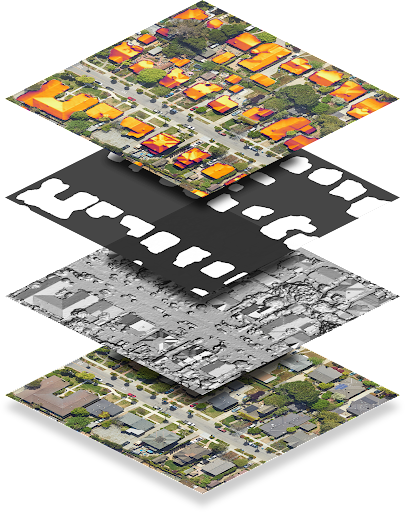
Điểm cuối dataLayers trả về dữ liệu được mã hoá dưới dạng tệp GeoTIFF. Bạn có thể dùng dữ liệu này trong mọi ứng dụng hệ thống thông tin địa lý (GIS) để thiết kế hệ thống năng lượng mặt trời.
Mỗi chuỗi trong phản hồi dataLayers chứa một URL mà bạn có thể dùng để tìm nạp GeoTIFF tương ứng. URL có hiệu lực tối đa một giờ sau khi được tạo từ yêu cầu lớp dữ liệu ban đầu. Bạn có thể lưu trữ tệp GeoTIFF trong tối đa 30 ngày.
Ngoại trừ lớp RGB, các tệp GeoTIFF không hiển thị chính xác bằng trình xem hình ảnh, vì nội dung là dữ liệu được mã hoá chứ không phải hình ảnh RGB. Bạn cũng không thể sử dụng trực tiếp các tệp GeoTIFF làm hình ảnh lớp phủ bằng Maps JavaScript API.
Bảng sau đây mô tả chi tiết từng lớp.
Lớp
Độ sâu pixel
Độ phân giải
Mô tả
Mô hình bề mặt kỹ thuật số (DSM)
Số thực 32 bit
0,1 m/pixel
Dữ liệu độ cao thể hiện địa hình bề mặt Trái Đất, bao gồm cả các đặc điểm tự nhiên và nhân tạo. Các giá trị được tính bằng mét so với mực nước biển. Vị trí không hợp lệ hoặc khu vực không có dữ liệu được lưu trữ dưới dạng -9999.
RGB
8 bit
0,1 m/pixel 0,25 m/pixel 0,5 m/pixel 1 m/pixel
Hình ảnh chụp từ trên cao về khu vực này. Tệp hình ảnh GeoTIFF chứa 3 dải tương ứng với các giá trị màu đỏ, xanh lục và xanh dương để tạo thành giá trị RGB 24 bit cho mỗi pixel.
Theo mặc định, độ phân giải pixel là 0,1 m/pixel.
Mặt nạ toà nhà
1 bit
0,1 m/pixel
Một bit cho mỗi pixel cho biết liệu pixel đó có được coi là một phần của mái nhà hay không.
Thông lượng hằng năm
Số thực 32 bit
0,1 m/pixel
Bản đồ thông lượng hằng năm hoặc bản đồ ánh sáng mặt trời hằng năm trên mái nhà của khu vực.
Giá trị là kWh/kW/năm.
Thông lượng được tính cho mọi vị trí, không chỉ trên mái nhà. Những vị trí không hợp lệ hoặc những khu vực mà chúng tôi không thể tính toán lưu lượng truy cập sẽ được lưu trữ dưới dạng -9999. Những vị trí nằm ngoài vùng phủ sóng của chúng tôi đều không hợp lệ.
Lưu ý: Đây là luồng không che.
Thông lượng hằng tháng
Số thực 32 bit
0,5 m/pixel
Bản đồ thông lượng hằng tháng (ánh sáng mặt trời trên mái nhà, được chia theo tháng) của khu vực. Giá trị là kWh/kW/năm. Tệp hình ảnh GeoTIFF chứa 12 dải tần tương ứng với tháng 1 đến tháng 12 theo thứ tự.
Bóng râm theo giờ
Số nguyên 32 bit
1 m/pixel
12 URL cho bản đồ bóng râm theo giờ tương ứng với tháng 1 – tháng 12, theo thứ tự.
Mỗi tệp GeoTIFF chứa 24 dải tần, tương ứng với 24 giờ trong ngày. Mỗi pixel là một số nguyên 32 bit, tương ứng với (tối đa) 31 ngày của tháng đó. 1 bit có nghĩa là vị trí tương ứng có thể nhìn thấy mặt trời vào ngày đó, giờ đó, tháng đó.
Vị trí không hợp lệ được lưu trữ dưới dạng -9999 và có bit 31 được đặt, vì điều đó tương ứng với ngày thứ 32 của tháng và do đó không hợp lệ.
Giải mã các tệp raster bóng râm theo giờ
Dữ liệu bóng râm theo giờ được mã hoá trong các tệp raster nhiều băng tần. Để tìm hiểu thêm về các kiến thức cơ bản về hình ảnh raster, hãy xem Các khái niệm về Solar API.
Khi yêu cầu dữ liệu bóng râm theo giờ, bạn có thể nhận được tối đa 12 tệp raster, mỗi tệp cho một tháng trong năm dương lịch (từ tháng 1 đến tháng 12). Mỗi hình ảnh raster bao gồm 24 lớp hoặc dải tần, tương ứng với 24 giờ trong ngày.
Mỗi dải tần được biểu thị bằng một ma trận gồm các ô hoặc pixel. Mỗi pixel có độ sâu 32 bit, tương ứng với 31 ngày (tối đa) trong tháng.
Do đó, để giải mã ngày, giờ và tháng của dữ liệu bóng râm, bạn cần hiểu rõ bit, dải tần và raster mà bạn đang phân tích.
Ví dụ: để xác định xem một vị trí nhất định tại toạ độ (x, y) có nhìn thấy mặt trời lúc 4:00 chiều ngày 22 tháng 6 hay không, hãy làm như sau:
Đưa ra yêu cầu về lớp dữ liệu cho tất cả các lớp cho vị trí (x, y).
Vì tháng 6 là tháng thứ sáu trong năm, hãy tìm nạp URL thứ sáu trong danh sách hourlyShadeUrls.
Các khung giờ được cung cấp theo định dạng 24 giờ. Để lấy dữ liệu cho 4:00 PM (16:00), hãy tra cứu kênh thứ 17.
Chỉ mục bit (ngày) từ 0. Để lấy dữ liệu cho ngày 22 tháng 6, hãy đọc bit 21.
Các bit cung cấp dữ liệu nhị phân cho biết liệu vị trí đó có thấy mặt trời vào ngày và giờ nhất định hay không. Nếu bit là 1, thì vị trí đó có nắng. Nếu bit là 0, vị trí đó có bóng râm.
[null,null,["Cập nhật lần gần đây nhất: 2025-08-27 UTC."],[[["\u003cp\u003eThe dataLayers endpoint provides access to various geographical data layers like elevation, aerial imagery, and solar potential, encoded in GeoTIFF format for use in GIS applications.\u003c/p\u003e\n"],["\u003cp\u003eGeoTIFF URLs are valid for one hour and the downloaded files can be stored for up to 30 days, with most layers requiring specialized software for proper visualization due to data encoding.\u003c/p\u003e\n"],["\u003cp\u003eThe hourly shade layer is encoded to indicate sun exposure for each location at a specific time and day of the month, requiring bitwise operations to decode the information.\u003c/p\u003e\n"],["\u003cp\u003eThe hourly shade data uses the location's regional time zone, assumes no leap days or daylight savings, and treats all days as 24 hours long with standard time noon.\u003c/p\u003e\n"]]],["The `dataLayers` endpoint provides GeoTIFF files for solar system design, accessible via URLs valid for one hour, and storable for 30 days. These files include: Digital Surface Model (DSM) for elevation; RGB imagery; Building mask indicating rooftop pixels; Annual flux showing annual sunlight; Monthly flux with sunlight data per month and hourly shade containing 12 rasters, with 24 layers for each hour of the day each month, each one represented by bits indicating whether the location saw the sun on a given day, hour and month.\n"],null,["# About GeoTIFF files\n\n**European Economic Area (EEA) developers** If your billing address is in the European Economic Area, effective on 8 July 2025, the [Google\n| Maps Platform EEA Terms of Service](https://cloud.google.com/terms/maps-platform/eea) will apply to your use of the Services. [Learn more](/maps/comms/eea/faq). In addition, certain content from the Solar API will no longer be returned. [Learn more](/maps/comms/eea/solar).\n\nThe [dataLayers](/maps/documentation/solar/data-layers) endpoint\nreturns data encoded as GeoTIFF files, which can be used in any geographic\ninformation system (GIS) application to design solar systems.\n\nEach string in the dataLayers response contains a URL, which you can\nuse to fetch the corresponding GeoTIFF. URLs are valid for up to an hour after\nthey are generated from the original data layers request. GeoTIFF files can be\nstored for up to 30 days.\n\nWith the exception of the RGB layer, GeoTIFF files don't display correctly with\nan image viewer, as the content is encoded data rather than RGB images. GeoTIFF\nfiles also cannot be used directly as an overlay image with Maps Javascript API.\n\nThe following table describes each layer in detail.\n\n| Layer | Pixel depth | Resolution | Description |\n|-----------------------------|----------------|------------------------------------------------|---------------------------------------------------------------------------------------------------------------------------------------------------------------------------------------------------------------------------------------------------------------------------------------------------------------------------------------------------------------------------------------------------------------------------------------------------------------------------------------------------------------|\n| Digital Surface Model (DSM) | 32-bit float | 0.1 m/pixel | Elevation data that represents the topography of Earth's surface, including natural and built features. Values are in meters above sea level. Invalid locations, or areas where we don't have data, are stored as -9999. |\n| RGB | 8-bit | 0.1 m/pixel 0.25 m/pixel 0.5 m/pixel 1 m/pixel | An aerial image of the region. The GeoTIFF imagery file contains three bands corresponding to red, green and blue values in order to form 24-bit RGB value for each pixel. By default, the pixel resolution is 0.1 m/pixel. |\n| Building mask | 1-bit | 0.1 m/pixel | One bit per pixel indicating whether that pixel is considered to be part of a rooftop. |\n| Annual flux | 32-bit float | 0.1 m/pixel | The annual flux map, or annual sunlight on roofs, of the region. Values are kWh/kW/year. Flux is computed for every location, not just building rooftops. Invalid locations, or areas where we couldn't calculate flux, are stored as -9999. Locations outside our [coverage area](/maps/documentation/solar/coverage) are invalid. **Note:** This is unmasked flux. |\n| Monthly flux | 32-bit float | 0.5 m/pixel | The monthly flux map (sunlight on roofs, broken down by month) of the region. Values are kWh/kW/year. The GeoTIFF imagery file contains 12 bands corresponding to January --- December, in order. |\n| Hourly shade | 32-bit integer | 1 m/pixel | 12 URLs for hourly shade maps corresponding to January --- December, in order. Each GeoTIFF file contains 24 bands, corresponding to the 24 hours of the day. Each pixel is a 32 bit integer, corresponding to the (up to) 31 days of that month. A 1 bit means that the corresponding location is able to see the sun on that day, at that hour, in that month. \u003cbr /\u003e Invalid locations are stored as -9999 and have bit 31 set, as that corresponds to the 32nd day of the month and is therefore invalid. |\n\nDecode hourly shade rasters\n---------------------------\n\nHourly shade data is encoded in multiband rasters. To learn more about raster\nbasics, see [Solar API Concepts](/maps/documentation/solar/concepts).\n\nWhen you make a request for hourly shade data, you can receive up to 12 rasters,\none for each month of the calendar year (January through December). Each raster\nis composed of 24 layers, or *bands*, which correspond to the 24 hours of the\nday.\n\nEach band is represented by a matrix of cells, or *pixels*. Each pixel has a\ndepth of 32 bits, which correspond to the (maximum) 31 days of the month.\nDecoding the day, time, and month of shade data, therefore, requires\nunderstanding the bit, band, and raster that you are analyzing.\n\nFor example, to identify whether a given location at coordinates (x, y) saw the\nsun at 4:00 PM on June 22, do the following:\n\n1. Make a data layers request for all layers for location (x, y).\n2. Because the month of June is the sixth month of the year, fetch the sixth URL in the `hourlyShadeUrls` list.\n3. Hourly bands are given in 24-hour time. To get data for 4:00 PM (16:00), look up the 17th channel.\n4. Bits (days) index from 0. To get data for the 22nd day of June, read bit 21.\n5. Bits provide binary data indicating whether that location saw sun at the given date and time. If the bit is 1, the location saw sun. If the bit is 0, the location saw shade.\n\nThe following code summarizes the steps above: \n\n```transact-sql\n(hourly_shade[month - 1])(x, y)[hour] & (1 \u003c\u003c (day - 1))\n```\n| **Note:** Hourly shade data is based on the regional time zone of the requested location. Hourly shade data also assumes that there are no leap days and that Daylight Savings Time does not exist. All days are assumed to be 24 hours long and noon is always \"standard time\" noon (12:00)."]]