Solar API משתמש בנתוני מקומות כדי לקבוע את סוג הבניין ומזהה בניינים על סמך צילומי לוויין. בדף הזה מוסבר איך לקבוע את המידע הסולארי של איזה בניין מוחזר בבקשה buildingInsights.
סוגי מבנים
Solar API תומך בבניינים מהסוג premise. הסוג הזה מציין מיקום עם שם, בדרך כלל בניין או קבוצת בניינים עם שם משותף.
סוגים אחרים, כמו subpremise או מתחמים – למשל, מבנים נפרדים שממוקמים בנכס יחיד, אלא אם הם רשומים כpremise – לא נתמכים.
גגות של מבנים
Solar API מזהה את המיקום האופטימלי של לוחות סולאריים על הגג על סמך תמונות לוויין. מבני מגורים, במיוחד גגות משופעים או גגות עם שיפוע, מזוהים ברמת דיוק גבוהה, בעוד שמבנים עם גגות שטוחים (לדוגמה, בנייני דירות או מבנים מסחריים) עשויים להיות מזוהים ברמת דיוק משתנה.
אם התגובה של buildingInsights לא כוללת את השדה solarPanelConfigs, סימן שהבניין עבר עיבוד בצורה תקינה, אבל לא הצלחנו להציב פאנלים על הגג. יכול להיות שהגג קטן מדי כדי להציב עליו פאנלים, או שיש עליו יותר מדי צל ולכן הפאנלים לא יכולים לייצר כמות משמעותית של אנרגיה.
חיפוש מכתובת
אפשר להמיר כתובת לקואורדינטות של קו רוחב וקו אורך באמצעות Geocoding API או השלמה אוטומטית למקומות API.
משתמשים ב-
place_idכדי להתייחס למקום התואם.משתמשים בקואורדינטות של קווי הרוחב והאורך של המקום בבקשה ל-Solar API
buildingInsights- אם Solar API מוצא בניין תואם, צריך לוודא שהערך של
place_idבתשובתbuildingInsightsזהה לערך שלplace_idמ-Geocoding API או מ-השלמה אוטומטית למקומות API. - כדי להגביל את התוצאות למקומות עם הסוג
premise, מוסיפים מסנן של סוג מקום לתגובות של Geocoding API או Places API.{ "name": "buildings/ChIJh0CMPQW7j4ARLrRiVvmg6Vs", "center": { "latitude": 37.4449739, "longitude": -122.13914659999998 },... }
- אם Solar API מוצא בניין תואם, צריך לוודא שהערך של
אתם יכולים להשתמש באפליקציית הדוגמה בקוד פתוח או לשלוח בקשת buildingInsights כדי לבדוק את place_id של מבנים שמכוסים על ידי Solar API.
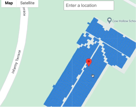
בחירת מיקום במפה
אפשר גם להציע חוויה משלימה על ידי מתן אפשרות למשתמשים לבחור את הבניין במפה באמצעות Maps JavaScript API. מחלקים את קו הרוחב וקו האורך של הבניין מאירוע העכבר, ואז מעבירים את הקואורדינטות האלה בבקשת buildingInsights.