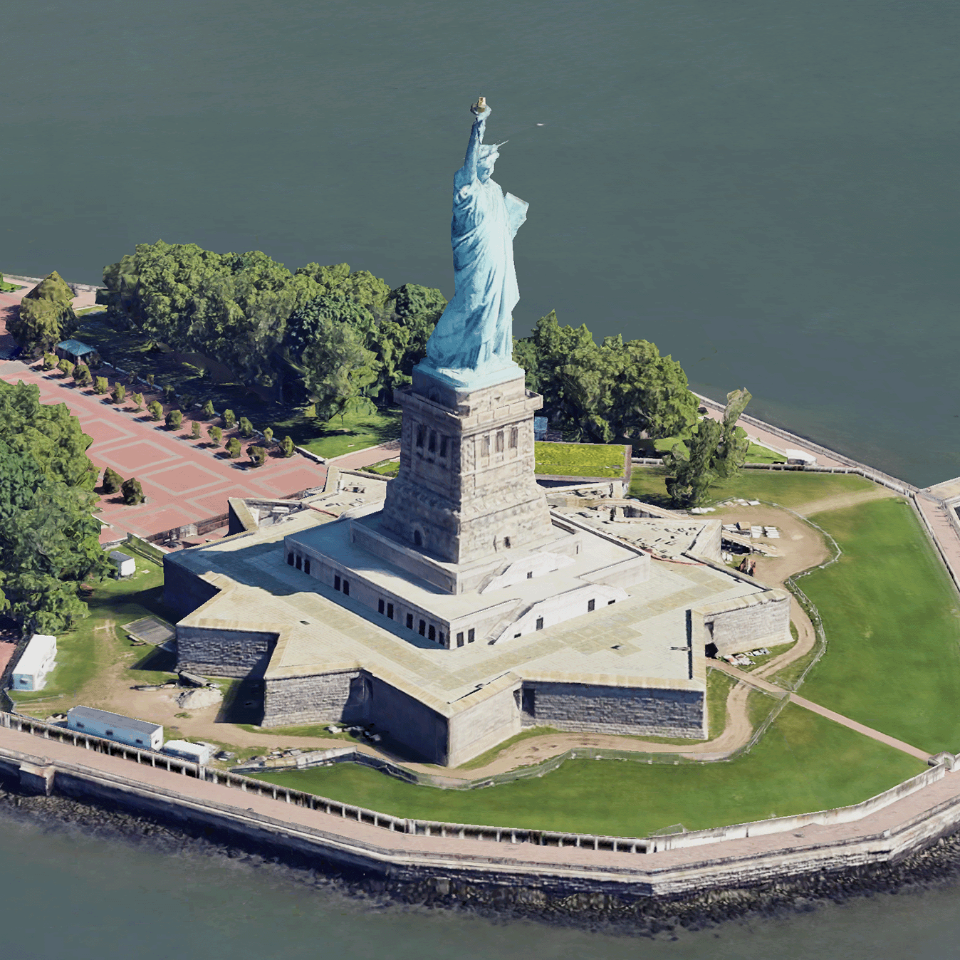
Обзор фотореалистичных 3D-плиток
Оптимизируйте свои подборки
Сохраняйте и классифицируйте контент в соответствии со своими настройками.
Разработчики Европейской экономической зоны (ЕЭЗ)
Фотореалистичные 3D-плитки — это фрагменты карт, содержащие 3D-геоданные Google в формате OGC 3D Tiles . Вы можете визуализировать 3D-карты Google с помощью собственного рендерера 3D-плиток или использовать библиотеку с открытым исходным кодом для 3D-геопространственной визуализации.
Зачем использовать 3D-плитку?
Google предлагает 3D-плитки для визуализации нового поколения. Вы можете использовать 3D-плитки для создания потрясающих трёхмерных перспективных видов, как в Google Планета Земля. Эти виды помогают пользователям лучше понимать географический контекст, улучшают навигацию и могут стать отличным примером места для повествования. Используя выбранный вами рендерер, вы также можете плавно перемещать камеру по сцене, рассматривая её с разных ракурсов.
Зоны покрытия
Ознакомьтесь с охватом API Map Tiles. Google регулярно обновляет и добавляет изображения.
3D-решения
Центр архитектуры платформы Google Карт содержит примеры 3D-решений, которые вы можете изучить, чтобы начать работу над своим приложением:
3D Area Explorer : позволяет вам исследовать окрестности и районы виртуально и в 3D с высокой степенью визуальной детализации.
3D-рассказывание историй : объединяет повествование и картографирование, позволяя создателям создавать захватывающие и интерактивные истории с использованием фотореалистичных 3D-плиток.
Если не указано иное, контент на этой странице предоставляется по лицензии Creative Commons "С указанием авторства 4.0", а примеры кода – по лицензии Apache 2.0. Подробнее об этом написано в правилах сайта. Java – это зарегистрированный товарный знак корпорации Oracle и ее аффилированных лиц.
Последнее обновление: 2025-08-29 UTC.
[null,null,["Последнее обновление: 2025-08-29 UTC."],[[["\u003cp\u003ePhotorealistic 3D Tiles are map tiles containing Google's 3D geodata in the OGC 3D Tiles format, allowing rendering with your own or open source 3D Tiles renderers.\u003c/p\u003e\n"],["\u003cp\u003e3D Tiles empowers next-generation visualization, enabling stunning 3D perspective views for enhanced geographic context, navigation, and storytelling.\u003c/p\u003e\n"],["\u003cp\u003eGoogle's 3D Tiles offer coverage detailed in the Map Tiles API documentation, with regular updates and imagery additions.\u003c/p\u003e\n"],["\u003cp\u003eExplore 3D solutions like the 3D Area Explorer for detailed virtual exploration and 3D Storytelling for immersive narratives using Photorealistic 3D Tiles on the Google Maps Platform Architecture Center.\u003c/p\u003e\n"]]],[],null,["# Photorealistic 3D Tiles overview\n\n**European Economic Area (EEA) developers** If your billing address is in the European Economic Area, effective on 8 July 2025, the [Google\n| Maps Platform EEA Terms of Service](https://cloud.google.com/terms/maps-platform/eea) will apply to your use of the Services. [Learn more](/maps/comms/eea/faq). In addition, certain content from the Map Tiles API will no longer be returned. [Learn more](/maps/comms/eea/map-tiles).\n\n:statue_of_liberty:Photorealistic 3D Tiles are map tiles that contain Google's 3D\ngeodata in the\n[OGC 3D Tiles format](https://www.ogc.org/standards/3DTiles).\nYou can render Google's 3D maps with your own 3D Tiles renderer, or you can use\nan open source library for 3D geospatial visualization.\n\nWhy use 3D Tiles?\n-----------------\n\nGoogle offers 3D Tiles for next-generation visualization use cases. You can use\n3D Tiles to build stunning 3D perspective views, just as you can with Google\nEarth. These views help your users better understand geographic context, improve\nhow they navigate, and they can showcase a place for storytelling. Using a\nrenderer of your choice, you can also smoothly maneuver your camera through a\nscene to view it from different angles.\n\nCoverage areas\n--------------\n\nReview the Map Tiles API's\n[coverage](/maps/coverage#countryregion-coverage). Google regularly updates and\nadds imagery.\n\n3D solutions\n------------\n\nThe [Google Maps Platform Architecture Center](/maps/architecture)\ncontains examples of 3D solutions that you can examine to get started with your\napp:\n\n- [3D Area Explorer](/maps/architecture/3d-area-explorer):\n Lets you explore neighborhoods and areas virtually and in 3D with a\n high degree of visual detail.\n\n- [3D Storytelling](/maps/architecture/3d-storytelling):\n Bridges storytelling and mapping, enabling creators to craft immersive and\n interactive narratives using Photorealistic 3D Tiles."]]