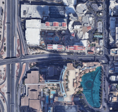
借助 Map Tiles API,您可以直接访问 Google 的 2D 图块和仿真 3D 图块。2D 图块是图像文件,描绘了按索引网格划分的世界。与 2D 图块一样,3D 图块也是图片文件,但其中包含建筑物、纪念碑和其他 POI 的仿真图像,您必须放大才能看到。您可以使用 2D 和 3D 图块在自己的应用中打造基于 Google 地图的沉浸式体验。
为何要使用 Map Tiles API
Map Tiles API 适用于以下 Google 客户:
希望在不使用 JavaScript 或移动 SDK 的情况下打造地图体验。
在桌面设备上,使用非基于网络的自定义应用。
适用于需要地图的自定义硬件和其他工具。
适用于汽车和航空导航系统。
希望获取比 Street View 服务或 Static Street View API 提供的更多街景元数据。
[null,null,["最后更新时间 (UTC):2025-08-29。"],[[["\u003cp\u003eThe Map Tiles API provides access to Google's 2D and photorealistic 3D Tiles for building custom map experiences.\u003c/p\u003e\n"],["\u003cp\u003eUse the Map Tiles API to create immersive visualizations, build maps without JavaScript or Mobile SDKs, and access extensive Street View metadata.\u003c/p\u003e\n"],["\u003cp\u003eChoose from Roadmap, Satellite, Terrain, Street View, and Photorealistic 3D map themes for your application.\u003c/p\u003e\n"],["\u003cp\u003eFollow the provided steps to set up your Google Cloud project, get an API key and session token, and request desired map tiles.\u003c/p\u003e\n"],["\u003cp\u003ePhotorealistic 3D Tiles can be accessed by specifying a root tileset URL to a compatible 3D Tiles renderer.\u003c/p\u003e\n"]]],["The Map Tiles API offers access to Google's 2D and photorealistic 3D Tiles for building custom map experiences. Available themes include roadmap, satellite, terrain, Street View, and photorealistic 3D. To use the API, you must review the terms, set up a Google Cloud project, and obtain an API key. 2D tile usage requires a session token before requesting tiles, and optional viewport information can be retrieved. 3D tile access only needs the API key.\n"],null,["# Map Tiles API overview\n\n**European Economic Area (EEA) developers** If your billing address is in the European Economic Area, effective on 8 July 2025, the [Google\n| Maps Platform EEA Terms of Service](https://cloud.google.com/terms/maps-platform/eea) will apply to your use of the Services. [Learn more](/maps/comms/eea/faq). In addition, certain content from the Map Tiles API will no longer be returned. [Learn more](/maps/comms/eea/map-tiles).\n\nThe Map Tiles API gives you direct access to Google's 2D\nTiles and Photorealistic 3D Tiles. 2D Tiles are image files that depict the\nworld divided into an indexed grid. Like 2D Tiles, 3D Tiles are image\nfiles, but they contain photorealistic imagery of buildings, monuments, and\nother POI, which you have to zoom in to see. You can use 2D and 3D Tiles to\nbuild a Google Maps-based immersive experience into your own application.\n\nWhy use the Map Tiles API\n-------------------------\n\nMap Tiles API is for Google customers who:\n\n- Want to build maps experiences without using JavaScript or Mobile SDKs.\n\n - On the desktop, with non-web-based custom apps.\n\n - For custom hardware and other tools that need a map.\n\n - For navigation systems for automotive and aviation.\n\n- Want more metadata for Street View than is provided by the Street View Service or Static Street View API.\n\n- Want to create highly customized and immersive visualizations in 2D and 3D.\n\nAvailable Map Tiles\n-------------------\n\nThe following thematic Map Tiles are served through the Map Tiles API. For\ncoverage info, review the\n[Google Maps Platform Coverage Details](/maps/coverage).\n\n| Map Theme | Description |\n|-----------------------------------------------------------------|-----------------------------------------------------------------------------------------------------------------------------|\n| [Roadmap](/maps/documentation/tile/roadmap) | The standard Google Maps basemap tiles + overlay data (with roads, buildings, points of interest, and political boundaries) |\n| [Satellite](/maps/documentation/tile/satellite) | Satellite and aerial imagery |\n| [Terrain](/maps/documentation/tile/terrain) | A hillshade and contour map that shows natural features such as vegetation |\n| [Street View](/maps/documentation/tile/streetview) | Street View panoramas with metadata |\n| [Photorealistic 3D](/maps/documentation/tile/3d-tiles-overview) | A 3D textured mesh with satellite and aerial imagery |\n\n| **Tip:** You can also use the Map Tiles API to access overlay information. For more information, see the optional [`overlay`](/maps/documentation/tile/session_tokens#overlay) field.\n\nHow to use the Map Tiles API\n----------------------------\n\n### 2D Tiles\n\n|---|------------------------------------------------------|--------------------------------------------------------------------------------------------------------------------------------------------------------------------------------------------------------------------------------------------------------------------------------------------------------------------------------------------------------------------------------------------------------------------|\n| 1 | **Review the Google Maps Platform Terms of Service** | For more information, see the [Google Maps Platform Terms of Service](https://cloud.google.com/maps-platform/terms) and [Map Tiles API Policies](/maps/documentation/tile/policies). |\n| 2 | **Get set up** | Start with [Set up your Google Cloud project](/maps/documentation/tile/cloud-setup) and complete the instructions that follow. |\n| 3 | **Get an API key** | Create and secure an API key. For more information, see [Use API Keys](/maps/documentation/tile/get-api-key). |\n| 4 | **Get a session token** | Retrieve a [session token](/maps/documentation/tile/session_tokens), specifying the [`mapType`](/maps/documentation/tile/session_tokens#required_fields), and other options for the session. |\n| 5 | **Request 2D Map Tiles** | Use your API key and session token to [request a map tile](/maps/documentation/tile/2d-tiles-overview#tile-request), [get a panorama ID](/maps/documentation/tile/streetview#panoid-search), or [get Street View metadata](/maps/documentation/tile/streetview#street_view_metadata). If you want to request Street View panoramas, then see [Street View Tiles](/maps/documentation/tile/streetview) for details. |\n| 6 | **Retrieve viewport information** | For basemap, satellite, and terrain tiles, you can [retrieve viewport information](/maps/documentation/tile/2d-tiles-overview#viewport_info_request) to get details about the displayed tiles. Viewport requests tell you which regions have imagery, and at what zoom levels, because not all regions support the maximum zoom level of 22. |\n\n### Photorealistic 3D Tiles\n\n|---|------------------------------------------------------|---------------------------------------------------------------------------------------------------------------------------------------------------------------------------------------------------------------------------------------------------|\n| 1 | **Review the Google Maps Platform Terms of Service** | For more information, see the [Google Maps Platform Terms of Service](https://cloud.google.com/maps-platform/terms) and [Map Tiles API Policies](/maps/documentation/tile/policies). |\n| 2 | **Get set up** | Start with [Set up your Google Cloud project](/maps/documentation/tile/cloud-setup) and complete the instructions that follow. |\n| 3 | **Get an API key** | Create and secure an API key. For more information, see [Use API Keys](/maps/documentation/tile/get-api-key). |\n| 4 | **Request 3D Photorealistic Tiles** | Once you have your API key, you can begin accessing photorealistic tiles by specifying a root tileset URL to a 3D Tiles renderer of your choice. For more information, see [Getting 3D tiles](/maps/documentation/tile/3d-tiles#getting_3d_tiles) |"]]