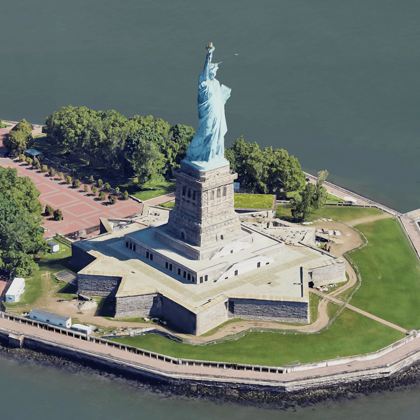
ภาพรวมการ์ด 3 มิติแบบภาพเสมือนจริง
จัดทุกอย่างให้เป็นระเบียบอยู่เสมอด้วยคอลเล็กชัน
บันทึกและจัดหมวดหมู่เนื้อหาตามค่ากำหนดของคุณ
นักพัฒนาแอปในเขตเศรษฐกิจยุโรป (EEA)
ชิ้นส่วนแผนที่ 3 มิติแบบสมจริงคือชิ้นส่วนแผนที่ที่มีข้อมูลเชิงภูมิศาสตร์ 3 มิติของ Google ในรูปแบบชิ้นส่วนแผนที่ 3 มิติของ OGC
คุณสามารถแสดงผลแผนที่ 3 มิติของ Google ด้วยโปรแกรมแสดงผล 3D Tiles ของคุณเอง หรือจะใช้
ไลบรารีโอเพนซอร์สสำหรับการแสดงภาพเชิงพื้นที่ 3 มิติก็ได้
เหตุผลที่ควรใช้ 3D Tiles
Google มี 3D Tiles สำหรับ Use Case การแสดงภาพรุ่นถัดไป คุณใช้
ไทล์ 3 มิติเพื่อสร้างมุมมองเปอร์สเปคทีฟ 3 มิติที่น่าทึ่งได้เช่นเดียวกับใน Google
Earth มุมมองเหล่านี้ช่วยให้ผู้ใช้เข้าใจบริบททางภูมิศาสตร์ได้ดียิ่งขึ้น ปรับปรุงวิธีนำทาง และแสดงสถานที่สำหรับการเล่าเรื่อง นอกจากนี้ คุณยังใช้
โปรแกรมแสดงผลที่ต้องการเพื่อบังคับกล้องผ่าน
ฉากได้อย่างราบรื่นเพื่อดูจากมุมต่างๆ
พื้นที่ให้บริการ
ตรวจสอบความครอบคลุมของ Map Tiles API Google จะอัปเดตและ
เพิ่มภาพเป็นประจำ
โซลูชัน 3 มิติ
ศูนย์สถาปัตยกรรม Google Maps Platform
มีตัวอย่างโซลูชัน 3 มิติที่คุณสามารถตรวจสอบเพื่อเริ่มต้นใช้งานแอป
ได้
เครื่องมือสำรวจพื้นที่ 3 มิติ:
ช่วยให้คุณสำรวจย่านและพื้นที่ต่างๆ แบบเสมือนจริงและในรูปแบบ 3 มิติ
พร้อมรายละเอียดภาพในระดับสูง
การเล่าเรื่องแบบ 3 มิติ
เชื่อมโยงการเล่าเรื่องและการทำแผนที่ ช่วยให้ครีเอเตอร์สร้างเรื่องราวที่สมจริงและ
โต้ตอบได้โดยใช้ชิ้นส่วนแผนที่ 3 มิติแบบสมจริง
เนื้อหาของหน้าเว็บนี้ได้รับอนุญาตภายใต้ใบอนุญาตที่ต้องระบุที่มาของครีเอทีฟคอมมอนส์ 4.0 และตัวอย่างโค้ดได้รับอนุญาตภายใต้ใบอนุญาต Apache 2.0 เว้นแต่จะระบุไว้เป็นอย่างอื่น โปรดดูรายละเอียดที่นโยบายเว็บไซต์ Google Developers Java เป็นเครื่องหมายการค้าจดทะเบียนของ Oracle และ/หรือบริษัทในเครือ
อัปเดตล่าสุด 2025-08-29 UTC
[null,null,["อัปเดตล่าสุด 2025-08-29 UTC"],[[["\u003cp\u003ePhotorealistic 3D Tiles are map tiles containing Google's 3D geodata in the OGC 3D Tiles format, allowing rendering with your own or open source 3D Tiles renderers.\u003c/p\u003e\n"],["\u003cp\u003e3D Tiles empowers next-generation visualization, enabling stunning 3D perspective views for enhanced geographic context, navigation, and storytelling.\u003c/p\u003e\n"],["\u003cp\u003eGoogle's 3D Tiles offer coverage detailed in the Map Tiles API documentation, with regular updates and imagery additions.\u003c/p\u003e\n"],["\u003cp\u003eExplore 3D solutions like the 3D Area Explorer for detailed virtual exploration and 3D Storytelling for immersive narratives using Photorealistic 3D Tiles on the Google Maps Platform Architecture Center.\u003c/p\u003e\n"]]],[],null,["# Photorealistic 3D Tiles overview\n\n**European Economic Area (EEA) developers** If your billing address is in the European Economic Area, effective on 8 July 2025, the [Google\n| Maps Platform EEA Terms of Service](https://cloud.google.com/terms/maps-platform/eea) will apply to your use of the Services. [Learn more](/maps/comms/eea/faq). In addition, certain content from the Map Tiles API will no longer be returned. [Learn more](/maps/comms/eea/map-tiles).\n\n:statue_of_liberty:Photorealistic 3D Tiles are map tiles that contain Google's 3D\ngeodata in the\n[OGC 3D Tiles format](https://www.ogc.org/standards/3DTiles).\nYou can render Google's 3D maps with your own 3D Tiles renderer, or you can use\nan open source library for 3D geospatial visualization.\n\nWhy use 3D Tiles?\n-----------------\n\nGoogle offers 3D Tiles for next-generation visualization use cases. You can use\n3D Tiles to build stunning 3D perspective views, just as you can with Google\nEarth. These views help your users better understand geographic context, improve\nhow they navigate, and they can showcase a place for storytelling. Using a\nrenderer of your choice, you can also smoothly maneuver your camera through a\nscene to view it from different angles.\n\nCoverage areas\n--------------\n\nReview the Map Tiles API's\n[coverage](/maps/coverage#countryregion-coverage). Google regularly updates and\nadds imagery.\n\n3D solutions\n------------\n\nThe [Google Maps Platform Architecture Center](/maps/architecture)\ncontains examples of 3D solutions that you can examine to get started with your\napp:\n\n- [3D Area Explorer](/maps/architecture/3d-area-explorer):\n Lets you explore neighborhoods and areas virtually and in 3D with a\n high degree of visual detail.\n\n- [3D Storytelling](/maps/architecture/3d-storytelling):\n Bridges storytelling and mapping, enabling creators to craft immersive and\n interactive narratives using Photorealistic 3D Tiles."]]