Tổng quan về Thẻ thông tin 3D ảnh thực
Sử dụng bộ sưu tập để sắp xếp ngăn nắp các trang
Lưu và phân loại nội dung dựa trên lựa chọn ưu tiên của bạn.
Nhà phát triển ở Khu vực kinh tế Châu Âu (EEA)
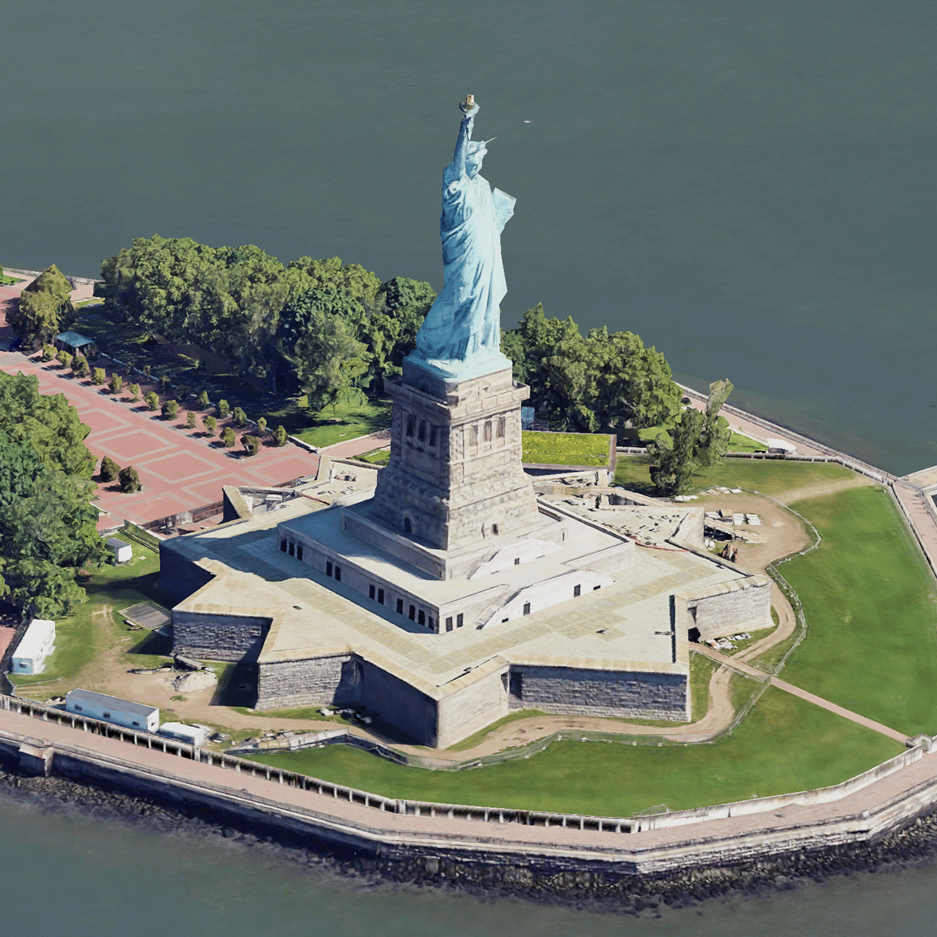
Ô 3D ảnh thực tế là các ô bản đồ chứa dữ liệu địa lý 3D của Google ở định dạng Ô 3D của OGC.
Bạn có thể kết xuất bản đồ 3D của Google bằng trình kết xuất 3D Tiles của riêng mình hoặc bạn có thể sử dụng một thư viện nguồn mở để trực quan hoá không gian địa lý 3D.
Tại sao nên sử dụng 3D Tiles?
Google cung cấp 3D Tiles cho các trường hợp sử dụng hình ảnh hoá thế hệ tiếp theo. Bạn có thể sử dụng Ô 3D để tạo chế độ xem phối cảnh 3D tuyệt đẹp, giống như trên Google Earth. Những chế độ xem này giúp người dùng hiểu rõ hơn về bối cảnh địa lý, cải thiện cách họ di chuyển và có thể giới thiệu một địa điểm để kể chuyện. Bằng cách sử dụng trình kết xuất mà bạn chọn, bạn cũng có thể di chuyển camera một cách mượt mà qua một cảnh để xem cảnh đó ở nhiều góc độ.
Vùng phủ sóng
Xem phạm vi phủ sóng của Map Tiles API. Google thường xuyên cập nhật và bổ sung hình ảnh.
Giải pháp 3D
Trung tâm Kiến trúc của Google Maps Platform có các ví dụ về giải pháp 3D mà bạn có thể xem xét để bắt đầu với ứng dụng của mình:
Công cụ khám phá khu vực ở dạng 3D: Cho phép bạn khám phá các khu dân cư và khu vực ở dạng 3D và thực tế ảo với độ chi tiết cao về hình ảnh.
Kể chuyện bằng hình ảnh 3D: Kết hợp kể chuyện và lập bản đồ, cho phép nhà sáng tạo tạo ra những câu chuyện sống động và mang tính tương tác bằng cách sử dụng Ô 3D ảnh thực tế.
Trừ phi có lưu ý khác, nội dung của trang này được cấp phép theo Giấy phép ghi nhận tác giả 4.0 của Creative Commons và các mẫu mã lập trình được cấp phép theo Giấy phép Apache 2.0. Để biết thông tin chi tiết, vui lòng tham khảo Chính sách trang web của Google Developers. Java là nhãn hiệu đã đăng ký của Oracle và/hoặc các đơn vị liên kết với Oracle.
Cập nhật lần gần đây nhất: 2025-08-29 UTC.
[null,null,["Cập nhật lần gần đây nhất: 2025-08-29 UTC."],[[["\u003cp\u003ePhotorealistic 3D Tiles are map tiles containing Google's 3D geodata in the OGC 3D Tiles format, allowing rendering with your own or open source 3D Tiles renderers.\u003c/p\u003e\n"],["\u003cp\u003e3D Tiles empowers next-generation visualization, enabling stunning 3D perspective views for enhanced geographic context, navigation, and storytelling.\u003c/p\u003e\n"],["\u003cp\u003eGoogle's 3D Tiles offer coverage detailed in the Map Tiles API documentation, with regular updates and imagery additions.\u003c/p\u003e\n"],["\u003cp\u003eExplore 3D solutions like the 3D Area Explorer for detailed virtual exploration and 3D Storytelling for immersive narratives using Photorealistic 3D Tiles on the Google Maps Platform Architecture Center.\u003c/p\u003e\n"]]],[],null,["# Photorealistic 3D Tiles overview\n\n**European Economic Area (EEA) developers** If your billing address is in the European Economic Area, effective on 8 July 2025, the [Google\n| Maps Platform EEA Terms of Service](https://cloud.google.com/terms/maps-platform/eea) will apply to your use of the Services. [Learn more](/maps/comms/eea/faq). In addition, certain content from the Map Tiles API will no longer be returned. [Learn more](/maps/comms/eea/map-tiles).\n\n:statue_of_liberty:Photorealistic 3D Tiles are map tiles that contain Google's 3D\ngeodata in the\n[OGC 3D Tiles format](https://www.ogc.org/standards/3DTiles).\nYou can render Google's 3D maps with your own 3D Tiles renderer, or you can use\nan open source library for 3D geospatial visualization.\n\nWhy use 3D Tiles?\n-----------------\n\nGoogle offers 3D Tiles for next-generation visualization use cases. You can use\n3D Tiles to build stunning 3D perspective views, just as you can with Google\nEarth. These views help your users better understand geographic context, improve\nhow they navigate, and they can showcase a place for storytelling. Using a\nrenderer of your choice, you can also smoothly maneuver your camera through a\nscene to view it from different angles.\n\nCoverage areas\n--------------\n\nReview the Map Tiles API's\n[coverage](/maps/coverage#countryregion-coverage). Google regularly updates and\nadds imagery.\n\n3D solutions\n------------\n\nThe [Google Maps Platform Architecture Center](/maps/architecture)\ncontains examples of 3D solutions that you can examine to get started with your\napp:\n\n- [3D Area Explorer](/maps/architecture/3d-area-explorer):\n Lets you explore neighborhoods and areas virtually and in 3D with a\n high degree of visual detail.\n\n- [3D Storytelling](/maps/architecture/3d-storytelling):\n Bridges storytelling and mapping, enabling creators to craft immersive and\n interactive narratives using Photorealistic 3D Tiles."]]