Koleksiyonlar ile düzeninizi koruyun
İçeriği tercihlerinize göre kaydedin ve kategorilere ayırın.
Avrupa Ekonomik Alanı (AEA) geliştiricileri
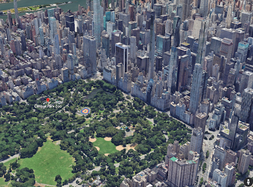
Gerçekçi fotoğraf 3B parçalar, yüksek çözünürlüklü görüntülerle dokulandırılmış bir 3B ağdır. Dünyanın birçok yerleşim yerinde yüksek çözünürlüklü 3D haritalar sunar. Bu API'ler, kullanıcılarınızın aşağıdaki işlemleri yapmasına yardımcı olmak için yeni nesil, etkileyici 3D görselleştirme deneyimleri sunmanıza olanak tanır:
Bir alanı anlama
Bir konuma güvenle gitme
Karar vermek için yeni yerleri değerlendirme
Gerçek dünyadaki değişiklikleri anlama
Başlamadan önce
Fotogerçekçi 3D Döşemeler API'sini kullanmaya başlamadan önce Hizmet Şartları'nı ve Harita Döşemeleri API Politikaları'nı incelemeniz gerekir. Ardından, faturalandırma hesabı olan bir projeye başlayabilir ve Map Tiles API'yi etkinleştirebilirsiniz. Daha fazla bilgi için Cloud Console'da kurulum başlıklı makaleyi inceleyin.
Kartları alma
API anahtarınızı aldıktan sonra, istediğiniz 3D Tiles oluşturucuya bir kök döşeme grubu URL'si belirterek fotogerçekçi döşemelere erişmeye başlayabilirsiniz. Bundan sonra, son kullanıcı haritayı keşfederken fotogerçekçi döşemeler için yapılan tüm sonraki aramalar oluşturucu tarafından otomatik olarak yapılır.
Oluşturma işlemi, tek bir kök döşeme grubu isteğinden en az üç saatlik döşeme isteğinde bulunabilir. Bu sınıra ulaştıktan sonra başka bir kök döşeme grubu isteğinde bulunmanız gerekir.
Örneğin, Cesium
JS ile 3D
Tiles'ı keşfetmeye başlamak için aşağıdaki JavaScript kodunu kullanabilirsiniz.
[null,null,["Son güncelleme tarihi: 2025-08-29 UTC."],[[["\u003cp\u003ePhotorealistic 3D Tiles provide high-resolution 3D maps of populated areas, enabling immersive visualization experiences for users.\u003c/p\u003e\n"],["\u003cp\u003eThese tiles help users understand, navigate, evaluate, and monitor changes in real-world locations.\u003c/p\u003e\n"],["\u003cp\u003eTo use the API, review the Terms of Service, Map Tiles API Policies, set up a billing account, enable the Map Tiles API, and obtain an API key.\u003c/p\u003e\n"],["\u003cp\u003eAccess tiles by providing a root tileset URL to a compatible 3D Tiles renderer (like CesiumJS) and ensure the renderer supports copyright attribution.\u003c/p\u003e\n"],["\u003cp\u003eA single root tileset request allows for at least three hours of tile requests before requiring a new request.\u003c/p\u003e\n"]]],["Photorealistic 3D Tiles provide high-resolution 3D maps, enabling users to understand areas, navigate confidently, evaluate locations, and observe real-world changes. To use the API, review the Terms of Service and API Policies, then set up a project with billing and enable the Map Tiles API. Access tiles by specifying a root tileset URL with an API key to a 3D Tiles renderer, which will automatically make subsequent tile requests. Renderers are allowed a maximum of 3 hours of requests per root request.\n"],null,["# Photorealistic 3D Tiles\n\n**European Economic Area (EEA) developers** If your billing address is in the European Economic Area, effective on 8 July 2025, the [Google\n| Maps Platform EEA Terms of Service](https://cloud.google.com/terms/maps-platform/eea) will apply to your use of the Services. [Learn more](/maps/comms/eea/faq). In addition, certain content from the Map Tiles API will no longer be returned. [Learn more](/maps/comms/eea/map-tiles).\n\nPhotorealistic 3D Tiles are a 3D mesh textured with high\nresolution imagery. They offer high-resolution 3D maps in many of the world's\npopulated areas. They let you power next-generation, immersive 3D\nvisualization experiences to help your users:\n\n- Understand an area\n\n- Confidently navigate to a location\n\n- Evaluate new places to make decisions\n\n- Understand how the real world changes\n\nBefore you begin\n----------------\n\nBefore you start using the Photorealistic 3D Tiles API, you need to review the\n[Terms of Service](https://cloud.google.com/maps-platform/terms/) and\n[Map Tiles API Policies](/maps/documentation/tile/policies). You may then\nstart a project with a billing account and enable the Map Tiles API. To\nlearn more, see [Setup in Cloud Console](/maps/documentation/tile/cloud-setup).\n\nGetting tiles\n-------------\n\nAfter obtaining your [API key](/maps/documentation/tile/get-api-key), you can\nbegin accessing photorealistic tiles by specifying a root tileset URL to a 3D\nTiles renderer of your choice. After that, all subsequent calls for\nphotorealistic tiles are automatically made by the renderer as the end user\nexplores the map.\n\nThe render can make at least three hours of tile requests from a single root\ntileset request. After reaching this limit, you must make another root tileset\nrequest.\n\nAs an example, you can use the following JavaScript code to start exploring 3D\nTiles with [Cesium\nJS](https://cesium.com/platform/cesiumjs/). \n\n \u003chead\u003e\n \u003cmeta charset=\"utf-8\"\u003e\n \u003cscript src=\"https://ajax.googleapis.com/ajax/libs/cesiumjs/1.105/Build/Cesium/Cesium.js\"\u003e\u003c/script\u003e\n \u003clink href=\"https://ajax.googleapis.com/ajax/libs/cesiumjs/1.105/Build/Cesium/Widgets/widgets.css\" rel=\"stylesheet\"\u003e\n \u003c/head\u003e\n\n \u003cbody\u003e\n \u003cdiv id=\"cesiumContainer\"\u003e\u003c/div\u003e\n \u003cscript\u003e\n const viewer = new Cesium.Viewer('cesiumContainer', {\n imageryProvider: false,\n baseLayerPicker: false,\n requestRenderMode: true,\n });\n\n const tileset = viewer.scene.primitives.add(new Cesium.Cesium3DTileset({\n url: \"https://tile.googleapis.com/v1/3dtiles/root.json?key=YOUR_API_KEY\",\n showCreditsOnScreen: true,\n }));\n\n viewer.scene.globe.show = false;\n \u003c/script\u003e\n \u003c/body\u003e\n\n| **Note:** To render Google's photorealistic tiles, you must use a 3D Tiles renderer that supports the display of copyright attribution. You can use **CesiumJS version 1.91** and later, or **Cesium for Unreal version 1.12** and later."]]