Riquadri di rilievo
Mantieni tutto organizzato con le raccolte
Salva e classifica i contenuti in base alle tue preferenze.
Sviluppatori dello Spazio economico europeo (SEE)
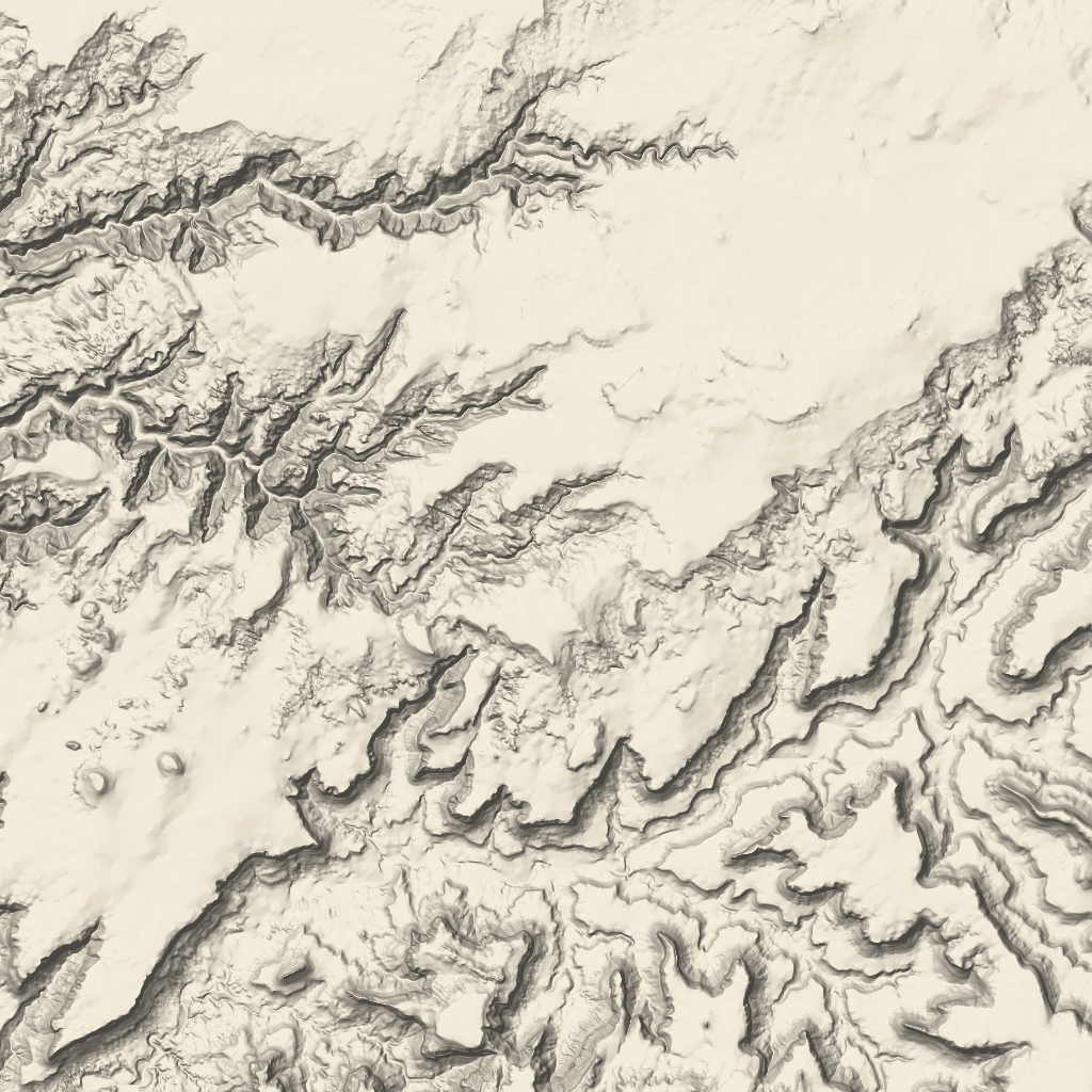
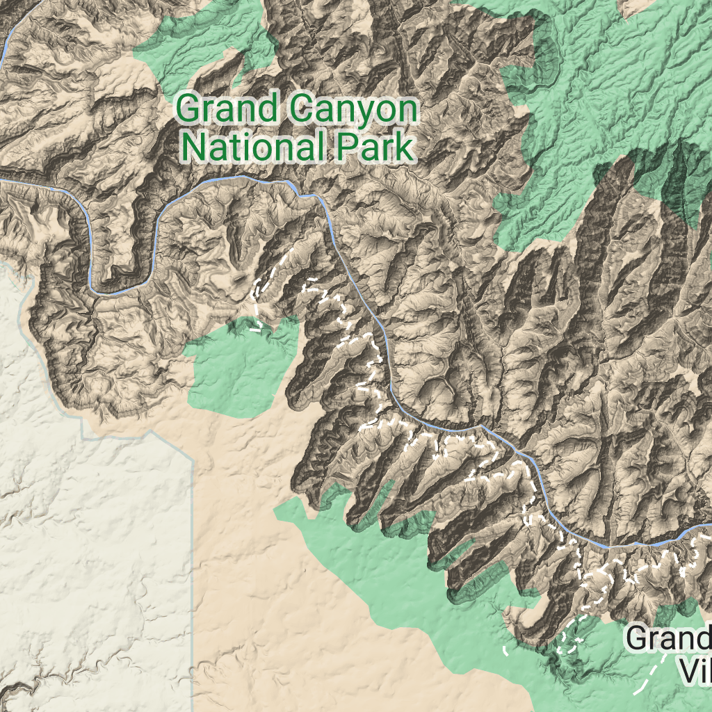
Le tessere del terreno sono tessere immagine che contengono la mappatura dell'ombreggiatura del rilievo
e le curve di livello. Sono incluse caratteristiche naturali come la vegetazione.
Ottenere i riquadri del terreno
Puoi iniziare a effettuare richieste di riquadri del terreno dopo aver ricevuto un token di sessione.
Poiché un token di sessione si applica all'intera sessione, non devi specificare
le opzioni della mappa con le richieste di riquadri.
Il seguente esempio di codice mostra una tipica richiesta di token di sessione per
i riquadri del terreno.
curl -X POST -d '{
"mapType": "terrain",
"language": "en-US",
"region": "US",
"layerTypes": ["layerRoadmap"]
}' \
-H 'Content-Type: application/json' \
"https://tile.googleapis.com/v1/createSession?key=YOUR_API_KEY"
Per ottenere i riquadri del terreno, devi inviare una richiesta HTTPS GET, come mostrato nell'esempio
seguente.
curl "https://tile.googleapis.com/v1/2dtiles/z/x/y?session=YOUR_SESSION_TOKEN&key=YOUR_API_KEY"
Esempio di richiesta di riquadro
Considera il seguente esempio, che richiede un singolo riquadro del terreno con livello di zoom 10 e coordinate x e y (192, 401).
curl "https://tile.googleapis.com/v1/2dtiles/10/192/401?session=YOUR_SESSION_TOKEN&key=YOUR_API_KEY" --output /tmp/example_tile.png
In questo esempio non è presente alcun messaggio di risposta dal server. Il riquadro viene scaricato in un file locale.

Per informazioni sulle intestazioni dei messaggi di risposta, vedi
Pre-fetching, memorizzazione nella cache o archiviazione dei contenuti.
Salvo quando diversamente specificato, i contenuti di questa pagina sono concessi in base alla licenza Creative Commons Attribution 4.0, mentre gli esempi di codice sono concessi in base alla licenza Apache 2.0. Per ulteriori dettagli, consulta le norme del sito di Google Developers. Java è un marchio registrato di Oracle e/o delle sue consociate.
Ultimo aggiornamento 2025-08-29 UTC.
[null,null,["Ultimo aggiornamento 2025-08-29 UTC."],[[["\u003cp\u003eTerrain tiles are image tiles that visually represent geographical features like hills, contours, and vegetation.\u003c/p\u003e\n"],["\u003cp\u003eTo request terrain tiles, you first need to obtain a session token using your API key and specifying map parameters.\u003c/p\u003e\n"],["\u003cp\u003eYou can then retrieve individual terrain tiles using an HTTPS GET request, providing the session token, API key, and desired tile coordinates (zoom level, x, and y).\u003c/p\u003e\n"],["\u003cp\u003eTerrain tiles are downloaded directly as image files without a server response message, allowing easy integration into mapping applications.\u003c/p\u003e\n"]]],["Terrain tiles, which include hillshade mapping, contour lines, and natural features, are accessed by first obtaining a session token via a POST request specifying the map type, language, region, and layer types. Subsequently, tiles are retrieved with HTTPS GET requests, providing the zoom level (z), x and y coordinates, and the session token. An example demonstrates requesting a tile at zoom level 10, with coordinates (192, 401). The tile data downloads to a local file, without a server response message.\n"],null,["# Terrain tiles\n\n**European Economic Area (EEA) developers** If your billing address is in the European Economic Area, effective on 8 July 2025, the [Google\n| Maps Platform EEA Terms of Service](https://cloud.google.com/terms/maps-platform/eea) will apply to your use of the Services. [Learn more](/maps/comms/eea/faq). In addition, certain content from the Map Tiles API will no longer be returned. [Learn more](/maps/comms/eea/map-tiles).\n\nTerrain tiles are image tiles that contain hillshade mapping\nand contour lines. They include natural features such as vegetation.\n\nGetting terrain tiles\n---------------------\n\nYou can begin making terrain tile requests after you get a session token.\nBecause a session token applies to the entire session, you don't have to specify\nthe map options with your tile requests.\n\nThe following code sample demonstrates a typical session token request for\nterrain tiles. \n\n```json\ncurl -X POST -d '{\n \"mapType\": \"terrain\",\n \"language\": \"en-US\",\n \"region\": \"US\",\n \"layerTypes\": [\"layerRoadmap\"]\n}' \\\n-H 'Content-Type: application/json' \\\n\"https://tile.googleapis.com/v1/createSession?key=YOUR_API_KEY\"\n```\n\nYou get terrain tiles by making an HTTPS GET request, as shown in the following\nexample. \n\n```json\ncurl \"https://tile.googleapis.com/v1/2dtiles/\u003cvar class=\"apiparam\" translate=\"no\"\u003ez\u003c/var\u003e/\u003cvar class=\"apiparam\" translate=\"no\"\u003ex\u003c/var\u003e/\u003cvar class=\"apiparam\" translate=\"no\"\u003ey\u003c/var\u003e?session=\u003cvar class=\"apiparam\" translate=\"no\"\u003eYOUR_SESSION_TOKEN\u003c/var\u003e&key=YOUR_API_KEY\"\n```\n\nExample tile request\n--------------------\n\nConsider the following example, which requests a single terrain tile with zoom\nlevel 10, with x and y coordinates of (192, 401). \n\n```json\ncurl \"https://tile.googleapis.com/v1/2dtiles/10/192/401?session=\u003cvar class=\"apiparam\" translate=\"no\"\u003eYOUR_SESSION_TOKEN\u003c/var\u003e&key=YOUR_API_KEY\" --output /tmp/example_tile.png\n```\n\nThere is no response message from the server in this example. Instead, the tile\njust downloads to a local file.\n\nFor information about response message headers, see\n[Pre-Fetching, Caching, or Storage of Content](/maps/documentation/tile/policies#pre-fetching,-caching,-or-storage-of-content)."]]