- 数据集可用时间
- 2010-02-01T00:00:00Z–2010-02-01T00:00:00Z
- 数据集生产者
- 澳大利亚地球科学中心
- 标签
说明
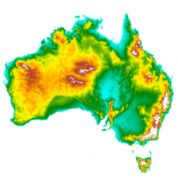
水文强制数字高程模型 (DEM-H) 源自 NASA 于 2000 年 2 月获取的 SRTM 数据。模型已进行水文条件调整并强制执行排水。DEM-H 基于 SRTM 海拔和映射的河流线捕获水流路径,并支持划分集水区和相关属性。该数据集通过使用 ANUDEM 软件强制执行水文连通性,从 1 秒平滑数字高程模型 (DEM-S; ANZCW0703014016) 派生而来,并使用选定的 AusHydro V1.6(2010 年 2 月)1:250,000 比例尺水系线 (ANZCW0503900101) 和从 DEM-S 派生的线来定义水系。排水强制执行功能可生成水文连接性的一致表示,但会因排水强制执行而产生一些高程伪影。我们正在准备对这些方法进行全面说明(Dowling 等人,准备中)。
此产品提供适用于水文分析(例如集水区定义和水流路径)的 DEM。
有几个区域出现了意外的负值:堪培拉附近 (150.443044, -35.355281) 的值为 -55,西澳大利亚附近 (124.84, -16.44) 的值为 -43。
频段
波段
像素大小:30.92 米(所有波段)
| 名称 | 单位 | 最小值 | 最大值 | 像素大小 | 说明 |
|---|---|---|---|---|---|
elevation |
米 | -31.37* | 2223.24* | 30.92 米 | 海拔 |
使用条款
使用条款
引用
引用:
Geoscience Australia,2015 年。澳大利亚的数字高程模型 (DEM),源自 LiDAR 5 米网格。Geoscience Australia,堪培拉。
通过 Earth Engine 探索
代码编辑器 (JavaScript)
var dataset = ee.Image('AU/GA/DEM_1SEC/v10/DEM-H');
var elevation = dataset.select('elevation');
var elevationVis = {
  min: -10.0,
  max: 1300.0,
  palette: [
    '3ae237', 'b5e22e', 'd6e21f', 'fff705', 'ffd611', 'ffb613', 'ff8b13',
    'ff6e08', 'ff500d', 'ff0000', 'de0101', 'c21301', '0602ff', '235cb1',
    '307ef3', '269db1', '30c8e2', '32d3ef', '3be285', '3ff38f', '86e26f'
  ],
};
Map.setCenter(133.95, -24.69, 5);
Map.addLayer(elevation, elevationVis, 'Elevation');