- 数据集可用时间
- 2010-07-01T00:00:00Z–2016-07-01T00:00:00Z
- 数据集生产者
- CPOM
- 标签
说明
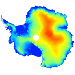
此数据集是南极冰盖和冰架的数字高程模型 (DEM),基于 CryoSat-2 卫星雷达高度计在 2010 年 7 月至 2016 年 7 月期间记录的观测数据。
DEM 是根据在 1、2 和 5 公里网格单元内累积的海拔测量值进行时空拟合而形成的,并以 1 公里的众数分辨率发布。在 NASA“冰桥行动”期间获取的 2.3*107 次机载激光高度计测量值与 DEM 之间的中位数差和均方根差分别为 -0.30 米和 13.50 米。
在高坡度区域,DEM 不确定性会增加,尤其是在以低分辨率模式获取高程测量值的区域;考虑到这一点,我们估计平均精度为 9.5 米。
频段
波段
像素大小:1,000 米(所有波段)
| 名称 | 单位 | 像元大小 | 说明 |
|---|---|---|---|
elevation |
米 | 1000 米 | 南极冰盖和冰架海拔。 |
data_composition |
1000 米 | 每个网格单元的高程数据处理方法。 |
|
slope |
度 | 1000 米 | 从海拔梯度得出的坡度。 |
z_smoothed |
米 | 1000 米 | 使用中值滤波器的平滑版高程模型。 |
z_uncertainty |
米 | 1000 米 | 高程模型的确定性,由观测网格单元中高程残差的均方根和插值网格单元中的克里金方差误差得出。 |
data_composition 类表
| 值 | 颜色 | 说明 |
|---|---|---|
| 0 | #000000 | 插值 |
| 1 | #cbcbcb | 1 公里健身 |
| 2 | #377eb7 | 重新采样的 2 公里拟合 |
| 3 | #e2191b | 重新采样的 5 公里拟合 |
使用条款
使用条款
引用
引用:
Slater, T.、Shepherd, A.、McMillan, M.、Muir, A.、Gilbert, L.、Hogg, A. E., Konrad, H. 和 Parrinello, T.:A new Digital Elevation Model of Antarctica derived from CryoSat-2 altimetry, The Cryosphere, doi:10.5194/tc-2017-223, 2018
DOI
通过 Earth Engine 探索
代码编辑器 (JavaScript)
var dataset = ee.Image('CPOM/CryoSat2/ANTARCTICA_DEM');

var visualization = {
  bands: ['elevation'],
  min: 0.0,
  max: 4000.0,
  palette: ['001fff', '00ffff', 'fbff00', 'ff0000']
};

Map.setCenter(17.0, -76.0, 3);

Map.addLayer(dataset, visualization, 'Elevation');