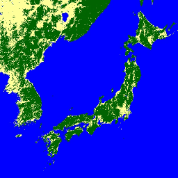
- 数据集可用性
- 2007-01-01T00:00:00Z–2018-01-01T00:00:00Z
- 数据集提供商
- JAXA EORC
- 标签
说明
您可以在 JAXA/ALOS/PALSAR/YEARLY/FNF4 中找到此数据集的较新版本,其中包含 2017 年至 2020 年的 4 个类别
全球森林/非森林 (FNF) 地图是通过对全球 25 米分辨率 PALSAR-2/PALSAR SAR 镶嵌图中的 SAR 图像(后向散射系数)进行分类来生成的,以便将强后向散射像素和低后向散射像素分别指定为“森林”和“非森林”。这里,“森林”是指面积大于 0.5 公顷且森林覆盖率超过 10% 的天然森林。此定义与联合国粮食及农业组织 (FAO) 的定义相同。由于森林的雷达后向散射取决于区域(气候带),因此森林/非森林的分类是使用与区域相关的后向散射阈值进行的。通过使用原位照片和高分辨率光学卫星图像来检查分类准确性。如需了解详情,请参阅提供方的数据集说明。
注意:
- 在高纬度森林地区,不同路径的后向散射值可能会有很大差异。这是由于冬季树木结冰导致后向散射强度发生变化所致。请注意,这可能会影响森林/非森林的分类。
频段
Pixel 大小
25 米
频段
| 名称 | 最小值 | 最大值 | 像素尺寸 | 说明 |
|---|---|---|---|---|
fnf |
1 | 3 | 米 | 森林/非森林地表覆盖分类 |
fnf 类表
| 值 | 颜色 | 说明 |
|---|---|---|
| 1 | #006400 | 森林 |
| 2 | #feff99 | 非森林 |
| 3 | #0000ff | 水 |
使用条款
使用条款
JAXA 保留对数据集的所有权,并且无法保证因使用数据集而导致或可能导致的问题。 任何希望使用这些数据集发布任何结果的人员都应在发布内容中明确确认数据的所有权。
引用
Masanobu Shimada、Takuya Itoh、Takeshi Motooka、Manabu Watanabe、Shiraishi Tomohiro、Rajesh Thapa 和 Richard Lucas,“New Global Forest/Non-forest Maps from ALOS PALSAR Data (2007-2010)”,《Remote Sensing of Environment》,第 155 期,第 13-31 页,2014 年 12 月。doi:10.1016/j.rse.2014.04.014。
使用 Earth Engine 探索
代码编辑器 (JavaScript)
var dataset = ee.ImageCollection('JAXA/ALOS/PALSAR/YEARLY/FNF')
                  .filterDate('2017-01-01', '2017-12-31');
var forestNonForest = dataset.select('fnf');
var forestNonForestVis = {
  min: 1,
  max: 3,
  palette: ['006400', 'feff99', '0000ff'],
};
Map.setCenter(136.85, 37.37, 4);
Map.addLayer(forestNonForest, forestNonForestVis, 'Forest/Non-Forest');
