- 数据集可用时间
- 2018-01-01T00:00:00Z–2021-11-28T00:00:00Z
- 数据集生产者
- 全球变化观测任务 (GCOM)
- 时间分辨率
- 1 天
- 标签
说明
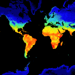
此产品是陆地表面的温度。
对于 2021 年 11 月 28 日之后的数据,请参阅V3 数据集。
GCOM-C 会进行长期持续的全球观测和数据收集,以阐明辐射收支和碳循环波动背后的机制,从而准确预测未来的气温上升。与此同时,通过与拥有气候数值模型的研究机构合作,有助于减少气候数值模型得出的升温预测中的误差,并提高各种环境变化预测的准确性。安装在 GCOM-C 上的 SGLI 是安装在 ADEOS-II (MIDORI II) 上的全球成像仪 (GLI) 的后续传感器,是一种成像辐射计,可在 19 个通道中测量近紫外到热红外区域 (380 nm-12 um) 的辐射。通过地面观测宽度大于 1,000 公里的观测,可以在日本附近的中纬度地区实现大约每两天一次的全球观测。此外,SGLI 的分辨率高于类似的全球传感器,并且具有偏振观测功能和多角度观测功能。
频段
波段
像素大小:4638.3 米(所有波段)
| 名称 | 单位 | 最小值 | 最大值 | 像素大小 | 说明 | ||||||||||||||||||||||||||||||||||||||||||||||||||||||||||||||||||||||||||||||||||||||||||||||
|---|---|---|---|---|---|---|---|---|---|---|---|---|---|---|---|---|---|---|---|---|---|---|---|---|---|---|---|---|---|---|---|---|---|---|---|---|---|---|---|---|---|---|---|---|---|---|---|---|---|---|---|---|---|---|---|---|---|---|---|---|---|---|---|---|---|---|---|---|---|---|---|---|---|---|---|---|---|---|---|---|---|---|---|---|---|---|---|---|---|---|---|---|---|---|---|---|---|---|---|
LST_AVE |
K | 0* | 65531* | 4638.3 米 | 地表温度。 |
||||||||||||||||||||||||||||||||||||||||||||||||||||||||||||||||||||||||||||||||||||||||||||||
LST_QA_flag |
4638.3 米 | LST QA |
|||||||||||||||||||||||||||||||||||||||||||||||||||||||||||||||||||||||||||||||||||||||||||||||||
图片属性
图像属性
| 名称 | 类型 | 说明 |
|---|---|---|
| ALGORITHM_VERSION | STRING | 算法版本 |
| GRID_INTERVAL | STRING | 空间分辨率 |
| GRID_INTERVAL_UNIT | STRING | GRID_INTERVAL 的单位 |
| IMAGE_END_TIME | STRING | 图片采集结束时间 |
| IMAGE_START_TIME | STRING | 图片采集开始时间 |
| PROCESSING_RESULT | STRING | 良好、一般、较差、NG |
| PROCESSING_UT | STRING | 处理时间 |
| PRODUCT_FILENAME | STRING | 源文件名 |
| PRODUCT_VERSION | STRING | 产品版本 |
| SATELLITE_DIRECTION | STRING | 卫星轨道方向
|
| LST_AVE_OFFSET | STRING | 偏移值 |
| LST_AVE_SLOPE | STRING | 坡度 |
使用条款
使用条款
您可以免费使用本数据集,不受任何限制(包括商业用途)。任何希望发布分析结果或增值数据产品的人员都应正确注明原始 G-Portal 数据的出处,例如“日本宇宙航空研究开发机构提供的 PR 数据”。对于增值数据产品,请注明原始 G-Portal 数据的提供方,例如“本增值数据产品的原始数据由日本宇宙航空研究开发机构提供。”
如需了解详情,请参阅 G-Portal 的服务条款(第 7 条)。
引用
Moriyama, M. (2020 年 5 月)。GCOM-C1/SGLI 地表温度产品算法理论基础文档(版本 2)。检索自 https://suzaku.eorc.jaxa.jp/GCOM_C/data/ATBD/ver2/V2ATBD_T4A_LST_Moriyama_r1.pdf
通过 Earth Engine 探索
代码编辑器 (JavaScript)
var dataset = ee.ImageCollection('JAXA/GCOM-C/L3/LAND/LST/V2')
                .filterDate('2020-01-01', '2020-02-01')
                // filter to daytime data only
                .filter(ee.Filter.eq('SATELLITE_DIRECTION', 'D'));

// Multiply with slope coefficient
var dataset = dataset.mean().multiply(0.02);

var visualization = {
  bands: ['LST_AVE'],
  min: 250,
  max: 316,
  palette: [
    '040274','040281','0502a3','0502b8','0502ce','0502e6',
    '0602ff','235cb1','307ef3','269db1','30c8e2','32d3ef',
    '3be285','3ff38f','86e26f','3ae237','b5e22e','d6e21f',
    'fff705','ffd611','ffb613','ff8b13','ff6e08','ff500d',
    'ff0000','de0101','c21301','a71001','911003',
  ]
};

Map.setCenter(128.45, 33.33, 5);

Map.addLayer(dataset, visualization, 'Land Surface Temperature');