Google uses AI technology to translate content into your preferred language. AI translations can contain errors.
MYD09GQ.061 Aqua Surface Reflectance Daily Global 250m
使用集合让一切井井有条
根据您的偏好保存内容并对其进行分类。
说明
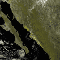
MODIS 地表反射率产品可估算在没有大气散射或吸收的情况下,地面测得的地表光谱反射率。
低级别数据已针对大气气体和气溶胶进行了校正。
MYD09GQ 版本 6.1 以正弦投影方式提供每日网格化 L2G 产品中的波段 1 和 2,分辨率为 250 米,包括一个质量控制层和五个观测层。此产品应与 MYD09GA 结合使用,后者存储了重要的质量和观测几何信息。
文档:
频段
频段
像元大小:250 米(所有频段)
名称
最小值
全速
缩放系数
像元大小
波长
说明
num_observations
0
127
250 米
无
每个 250 米像元的观测次数
sur_refl_b01
-100
16000
0.0001
250 米
620-670 纳米
地表反射率波段 1
sur_refl_b02
-100
16000
0.0001
250 米
841-876 纳米
波段 2 的地表反射率
QC_250m
250 米
无
地表反射率质量保证
QC_250m 的位掩码
位 0-1:MODLAND 质量保证位
0:全波段校正产品达到理想质量
1:部分或全部波段校正产品质量未达理想标准
2:全波段因云效应未能生成校正产品
3:因其他原因部分或全部波段未生成校正后产品(可能为填充值)
[注意,值 (11) 会覆盖值 (01)]
位 2-3:备用(未使用)
位 4-7:波段 1 数据质量
0:最高质量
7:探测器有噪声
8:探测器失效,在 L1B 级数据中采用插值
9:太阳天顶角 >= 86 度
10:太阳天顶角 >= 85 度且 < 86 度
11:缺少输入
12:至少一个大气参数使用内部常数替代气候数据
13:校正超出范围,像素受限于极端允许值
14:L1B 数据有误
15:因深海或云而未处理
位 8-11:波段 2 数据质量
0:最高质量
7:探测器有噪声
8:探测器失效,在 L1B 级数据中采用插值
9:太阳天顶角 >= 86 度
10:太阳天顶角 >= 85 度且 < 86 度
11:缺少输入
12:至少一个大气参数使用内部常数替代气候数据
13:校正超出范围,像素受限于极端允许值
14:L1B 数据有误
15:因深海或云而未处理
位 12:是否已执行大气校正
位 13:是否已执行邻近度校正
位 14-15:备用(未使用)
obscov
0
100
0.01
250 米
无
观测覆盖率(以百分比表示)
iobs_res
0
254
250 米
无
观测编号
orbit_pnt
0
15
250 米
无
轨道指针
granule_pnt
0
254
250 米
无
颗粒指针
使用条款
使用条款
通过 LP DAAC 获取的 MODIS 数据和产品在后续使用、销售或再分发方面没有任何限制。
通过 Earth Engine 探索
重要提示: Earth Engine 是一个平台,可用于对地理空间数据集进行 PB 级科学分析和可视化,既可用于公益用途,也可供企业和政府用户使用。Earth Engine 可免费用于研究、教育和公益用途。如需开始使用,请注册以获取 Earth Engine 访问权限 。
代码编辑器 (JavaScript)
var dataset = ee . ImageCollection ( 'MODIS/061/MYD09GQ' )
. filter ( ee . Filter . date ( '2018-01-01' , '2018-05-01' ));
var falseColorVis = {
min : - 100.0 ,
max : 8000.0 ,
bands : [ 'sur_refl_b02' , 'sur_refl_b02' , 'sur_refl_b01' ],
};
Map . setCenter ( 6.746 , 46.529 , 2 );
Map . addLayer ( dataset , falseColorVis , 'False Color' );
在代码编辑器中打开
[null,null,[],[],["The NASA MODIS MYD09GQ dataset, provided by the USGS EROS Center, offers daily surface reflectance data from 2002-07-04 to 2025-02-20. It provides bands 1 and 2 at a 250m resolution, corrected for atmospheric gases and aerosols. Key actions include accessing the data via Earth Engine with the snippet `ee.ImageCollection(\"MODIS/061/MYD09GQ\")`, utilizing bands like `sur_refl_b01`, `sur_refl_b02`, and `QC_250m`, and employing quality assurance data. The dataset is globally available without use restrictions.\n"]]