- 数据集可用时间
- 2021-01-01T00:00:00Z–2026-07-04T00:00:00Z
- 数据集生产者
- 美国地质调查局地球资源观测与科学中心下属的美国国家航空航天局陆地过程分布式主动存档中心
- 步频
- 8 天
- 标签
说明
MYD16A2 第 6.1 版蒸散量/潜热通量产品是 8 天合成产品,像素分辨率为 500 米。用于 MOD16 数据产品集合的算法基于 Penman-Monteith 方程的逻辑,其中包括每日气象再分析数据以及 MODIS 遥感数据产品(例如植被属性动态、反照率和土地覆盖)的输入。
ET、LE、PET 和 PLE 图层的像素值是 8 天合成期内所有日期的总和。请注意,每年的最后 8 天是 5 天或 6 天的合成期,具体取决于年份。
第 6.1 版 1B 级 (L1B) 产品经过各种校准更改后得到了改进,其中包括:对响应与扫描角度 (RVS) 方法的更改,这些更改会影响 Aqua 和 Terra MODIS 的反射率波段;对 Terra MODIS 红外 (IR) 波段中的光学串扰进行校正;以及对 2012 年至 2017 年期间 Terra MODIS 前向查找表 (LUT) 更新进行校正。 已对 L1B 反射太阳波段 (RSB) 应用偏振校正。该产品使用气候 LAI/FPAR 作为运行 LAI/FPAR 的备份。
根据 MODIS 科学团队 的说法, MYD16A2 6.1 产品不会提供 2021 年之前的数据。MODIS 科学团队建议使用经过填补的 MYD16A2GF 6.1 产品来获取 2000 年至 2021 年的数据,以及 2022 年的数据(如果可用)。 他们之所以建议这样做,是因为经过填补的产品在产品质量方面预计会更胜一筹,尤其是在常规产品性能会受到多云或低质量输入观测结果负面影响的区域。对于当年,在次年年初之前不会有经过填补的产品(即 2023 年的数据应在 2024 年初提供)。因此,如果用户需要 2023 年(或未来“当年”)的 MYD16A2GF 6.1 数据,他们建议使用 MYD16A2 6.1 产品,该产品是使用每日观测结果生成的,并使用气候观测结果替换多云或低质量的观测结果。
文档:
频段
频段
像素大小:500 米(所有频段)
| 名称 | 单位 | 最小值 | 全速 | 缩放系数 | 像素尺寸 | 说明 | |||||||||||||||||||||||||||||||||||||||||||||||||||||||||||||||||||||||||||||||||||||||||||||
|---|---|---|---|---|---|---|---|---|---|---|---|---|---|---|---|---|---|---|---|---|---|---|---|---|---|---|---|---|---|---|---|---|---|---|---|---|---|---|---|---|---|---|---|---|---|---|---|---|---|---|---|---|---|---|---|---|---|---|---|---|---|---|---|---|---|---|---|---|---|---|---|---|---|---|---|---|---|---|---|---|---|---|---|---|---|---|---|---|---|---|---|---|---|---|---|---|---|---|---|
ET |
千克/平方米/8 天 | -32767 | 32700 | 0.1 | 500 米 | 总蒸散量 |
|||||||||||||||||||||||||||||||||||||||||||||||||||||||||||||||||||||||||||||||||||||||||||||
LE |
焦耳/平方米/天 | -32767 | 32700 | 10000 | 500 米 | 平均潜热通量 |
|||||||||||||||||||||||||||||||||||||||||||||||||||||||||||||||||||||||||||||||||||||||||||||
PET |
千克/平方米/8 天 | -32767 | 32700 | 0.1 | 500 米 | 总潜在蒸散量 |
|||||||||||||||||||||||||||||||||||||||||||||||||||||||||||||||||||||||||||||||||||||||||||||
PLE |
焦耳/平方米/天 | -32767 | 32700 | 10000 | 500 米 | 平均潜在潜热通量 |
|||||||||||||||||||||||||||||||||||||||||||||||||||||||||||||||||||||||||||||||||||||||||||||
ET_QC |
500 米 | 蒸散量质量控制标志 |
|||||||||||||||||||||||||||||||||||||||||||||||||||||||||||||||||||||||||||||||||||||||||||||||||
图像属性
图像属性
| 名称 | 类型 | 说明 |
|---|---|---|
| num_tiles | INT | 用于创建此图像的源图块数量。 |
使用条款
使用条款
通过 LP DAAC 获取的 MODIS 数据和产品在后续使用、销售或再分发方面没有任何限制。
引用
如需了解如何引用 LP DAAC 数据集,请访问 LP DAAC 的“引用我们的数据”页面 。
DOI
通过 Earth Engine 探索
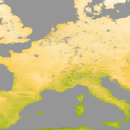
代码编辑器 (JavaScript)
var dataset = ee.ImageCollection('MODIS/061/MYD16A2')
                  .filter(ee.Filter.date('2021-01-01', '2021-02-01'));
var evapotranspiration = dataset.select('ET');
var evapotranspirationVis = {
  min: 0.0,
  max: 300.0,
  palette: [
    'ffffff', 'fcd163', '99b718', '66a000', '3e8601', '207401', '056201',
    '004c00', '011301'
  ],
};
Map.setCenter(6.746, 46.529, 2);
Map.addLayer(
    evapotranspiration, evapotranspirationVis, 'Evapotranspiration');