- 数据集可用时间
- 2000-02-24T00:00:00Z–2026-07-20T00:00:00Z
- 数据集生产者
- 美国地质调查局地球资源观测与科学中心下属的美国国家航空航天局陆地过程分布式主动存档中心
- 时间分辨率
- 1 天
- 标签
说明
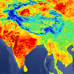
MYD21A1N 数据集每天由夜间 2 级格网 (L2G) 中间 LST 产品生成,空间分辨率为 1,000 米。L2G 流程可将每日 MOD21 轨道分片数据映射到正弦 MODIS 网格,并存储特定日期落在网格单元中的所有观测结果。MOD21A1 算法会针对每个像元对这些观测结果进行排序,并根据所有无云且 LST 和 E 准确度良好的观测结果的平均值来估计最终的 LST 值。夜间平均值会根据相应小区的观测覆盖率进行加权。系统只会考虑观测覆盖率高于 15% 阈值的观测结果。MYD21A1N 产品包含计算出的 LST 以及质量控制、三个发射率波段、观测天顶角和观测时间。
文档:
频段
波段
像素大小:1,000 米(所有波段)
| 名称 | 单位 | 最小值 | 最大值 | 像素大小 | 说明 | ||||||||||||||||||||||||||||||||||||||||||||||||||||||||||||||||||||||||||||||||||||||||||||||
|---|---|---|---|---|---|---|---|---|---|---|---|---|---|---|---|---|---|---|---|---|---|---|---|---|---|---|---|---|---|---|---|---|---|---|---|---|---|---|---|---|---|---|---|---|---|---|---|---|---|---|---|---|---|---|---|---|---|---|---|---|---|---|---|---|---|---|---|---|---|---|---|---|---|---|---|---|---|---|---|---|---|---|---|---|---|---|---|---|---|---|---|---|---|---|---|---|---|---|---|
LST_1KM |
K | 7500 | 65535 | 1000 米 | 地表温度 |
||||||||||||||||||||||||||||||||||||||||||||||||||||||||||||||||||||||||||||||||||||||||||||||
QC |
1000 米 | 质量控制 |
|||||||||||||||||||||||||||||||||||||||||||||||||||||||||||||||||||||||||||||||||||||||||||||||||
Emis_29 |
0 | 255 | 1000 米 | 频段 29 发射率 |
|||||||||||||||||||||||||||||||||||||||||||||||||||||||||||||||||||||||||||||||||||||||||||||||
Emis_31 |
1 | 255 | 1000 米 | 波段 31 的发射率 |
|||||||||||||||||||||||||||||||||||||||||||||||||||||||||||||||||||||||||||||||||||||||||||||||
Emis_32 |
1 | 255 | 1000 米 | 波段 32 发射率 |
|||||||||||||||||||||||||||||||||||||||||||||||||||||||||||||||||||||||||||||||||||||||||||||||
View_Angle |
度 | 0 | 130 | 1000 米 | MODIS 观测天顶角 |
||||||||||||||||||||||||||||||||||||||||||||||||||||||||||||||||||||||||||||||||||||||||||||||
View_Time |
小时 | 0 | 240 | 1000 米 | MODIS 观测时间 |
||||||||||||||||||||||||||||||||||||||||||||||||||||||||||||||||||||||||||||||||||||||||||||||
使用条款
使用条款
通过 LP DAAC 获取的 MODIS 数据和产品在后续使用、销售或再分发方面没有任何限制。
引用
引用:
如需了解如何引用 LP DAAC 数据集,请访问 LP DAAC 的“引用我们的数据”页面。
DOI
通过 Earth Engine 探索
代码编辑器 (JavaScript)
var dataset = ee.ImageCollection('MODIS/061/MYD21A1N')
                  .filter(ee.Filter.date('2018-01-01', '2018-05-01'));
var landSurfaceTemperature = dataset.select('LST_1KM');
var landSurfaceTemperatureVis = {
  min: 216.0,
  max: 348.0,
  palette: [
    '040274', '040281', '0502a3', '0502b8', '0502ce', '0502e6',
    '0602ff', '235cb1', '307ef3', '269db1', '30c8e2', '32d3ef',
    '3be285', '3ff38f', '86e26f', '3ae237', 'b5e22e', 'd6e21f',
    'fff705', 'ffd611', 'ffb613', 'ff8b13', 'ff6e08', 'ff500d',
    'ff0000', 'de0101', 'c21301', 'a71001', '911003'
  ],
};
Map.setCenter(6.746, 46.529, 2);
Map.addLayer(
    landSurfaceTemperature, landSurfaceTemperatureVis,
    'Land Surface Temperature');