- 数据集可用性
- 1999-06-30T00:00:00Z–2002-09-04T00:00:00Z
- 数据集提供商
- NASA NSIDC DAAC at CIRES
- 标签
说明
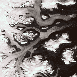
此数据集提供格陵兰冰盖的完整 15 米分辨率图像镶嵌,该镶嵌图源自 1999 年至 2002 年的 Landsat 7 ETM+ 和 RADARSAT-1 SAR 图像。这些方法包括图像云遮罩、全色锐化、图像采样和调整大小以及图像共同配准的组合。如需详细了解处理方法,请参阅 Howat, 2014。
备注
- GIMP DEM 或 GIMP 2000 Image Mosaic 图片的用户可能会发现,使用相应的 15 米海洋掩码图片“格陵兰冰盖测绘项目 (GIMP) 陆地冰和海洋分类掩码”遮盖格陵兰海岸线以外的区域很有帮助,
- SAR 数据以 20 米分辨率分发。通过双线性插值将数据上采样到 15 米,以匹配 Landsat 波段 8 的分辨率。
频段
频段
| 名称 | 像素尺寸 | 波长 | 说明 |
|---|---|---|---|
B1 |
15 米 | 0.45 - 0.52 微米 | Landsat 7 ETM+ 蓝色 |
B2 |
15 米 | 0.52 - 0.60 μm | Landsat 7 ETM+ 绿色 |
B3 |
15 米 | 0.63 - 0.69 微米 | Landsat 7 ETM+ 红色 |
B4 |
15 米 | 0.77 - 0.90 微米 | Landsat 7 ETM+ 近红外 |
B5 |
30 米 | 1.55 - 1.75 微米 | Landsat 7 ETM+ 短波红外 1 |
B6_low_gain |
30 米 | 10.40 - 12.50 μm | Landsat 7 ETM+ 低增益热红外 1。 此波段具有更广的动态范围和更低的光谱分辨率(灵敏度),在高数字序号 (DN) 值下饱和度更低。从 60 分钟重新采样到 30 分钟。 |
B6_high_gain |
30 米 | 10.40 - 12.50 μm | Landsat 7 ETM+ 高增益热红外 1。 此波段具有较高的辐射分辨率(灵敏度),但动态范围更受限。从 60 分钟重新采样到 30 分钟。 |
B7 |
30 米 | 2.08 - 2.35 微米 | Landsat 7 ETM+ 短波红外 2 |
B8 |
15 米 | 0.52 - 0.90 微米 | Landsat 7 ETM+ 全色 |
B8_radarsat |
15 米 | 无 | RADARSAT-1 合成孔径雷达振幅图像 |
使用条款
使用条款
使用这些数据的前提条件是,您必须使用给定的引用信息来引用相应的数据集。
引用
引用:
Howat, I.M.、A. Negrete、B.E. Smith,2014 年,《格陵兰冰盖测绘项目 (GIMP) 土地分类和地表高程数据集》,《冰冻圈》,8,1509-1518,doi:10.5194/tc-8-1509-2014 文章 PDF
DOI
使用 Earth Engine 探索
代码编辑器 (JavaScript)
var dataset = ee.Image('OSU/GIMP/2000_IMAGERY_MOSAIC');
var greenlandImage = dataset.select(['B3', 'B2', 'B1']);
var visParams = {
  min: 0.0,
  max: 255.0,
};
Map.setCenter(-29.1605, 70.4, 9);
Map.addLayer(greenlandImage, visParams, 'Greenland Pansharpened Image');
