Page Summary
-
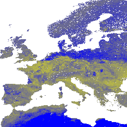
This dataset provides sand content data in % (kg/kg) at six standard depths (0, 10, 30, 60, 100, and 200 cm) globally at a 250m resolution, excluding Antarctica.
-
The data is based on machine learning predictions using a global compilation of soil profiles and samples.
-
The dataset includes six bands, each representing sand content at a specific depth, with values ranging from 1% to 100%.
-
The dataset is available from 1950-01-01T00:00:00Z to 2018-01-01T00:00:00Z and is provided by EnvirometriX Ltd.
-
The terms of use for this dataset are CC-BY-SA-4.0.
- Dataset Availability
- 1950-01-01T00:00:00Z–2018-01-01T00:00:00Z
- Dataset Producer
- EnvirometriX Ltd
- Tags
Description
Sand content in % (kg / kg) at 6 standard depths (0, 10, 30, 60, 100 and 200 cm) at 250 m resolution
Based on machine learning predictions from global compilation of soil profiles and samples. Processing steps are described in detail here. Antarctica is not included.
To access and visualize maps outside of Earth Engine, use this page.
If you discover a bug, artifact or inconsistency in the LandGIS maps or if you have a question please use the following channels:
Bands
Bands
Pixel size: 250 meters (all bands)
| Name | Units | Min | Max | Pixel Size | Description |
|---|---|---|---|---|---|
b0 |
% (kg / kg) | 1* | 100* | 250 meters | Sand content at 0 cm depth |
b10 |
% (kg / kg) | 1* | 100* | 250 meters | Sand content at 10 cm depth |
b30 |
% (kg / kg) | 1* | 100* | 250 meters | Sand content at 30 cm depth |
b60 |
% (kg / kg) | 1* | 100* | 250 meters | Sand content at 60 cm depth |
b100 |
% (kg / kg) | 1* | 100* | 250 meters | Sand content at 100 cm depth |
b200 |
% (kg / kg) | 1* | 100* | 250 meters | Sand content at 200 cm depth |
Terms of Use
Terms of Use
Citations
Tomislav Hengl. (2018). Sand content in % (kg / kg) at 6 standard depths (0, 10, 30, 60, 100 and 200 cm) at 250 m resolution (Version v02) [Data set]. 10.5281/zenodo.1476851
DOIs
Explore with Earth Engine
Code Editor (JavaScript)
var dataset = ee.Image('OpenLandMap/SOL/SOL_SAND-WFRACTION_USDA-3A1A1A_M/v02');

var visualization = {
  bands: ['b0'],
  min: 1.0,
  max: 100.0,
  palette: [
    'ffff00', 'f8f806', 'f1f10c', 'ebeb13', 'e4e419', 'dddd20',
    'd7d726', 'd0d02d', 'caca33', 'c3c33a', 'bcbc41', 'b6b647',
    'b0b04e', 'a9a954', 'a3a35a', '9c9c61', '959568', '8f8f6e',
    '898975', '82827b', '7b7b82', '757589', '6e6e8f', '686895',
    '61619c', '5a5aa3', '5454a9', '4d4db0', '4747b6', '4141bc',
    '3a3ac3', '3333ca', '2d2dd0', '2626d7', '2020dd', '1919e4',
    '1212eb', '0c0cf1', '0606f8', '0000ff',
  ]
};

Map.centerObject(dataset);

Map.addLayer(dataset, visualization, 'Sand content in % (kg / kg)');