Page Summary
-
This dataset provides global soil water content predictions at 250m resolution for 33kPa and 1500kPa suctions at six standard depths.
-
The predictions are based on a compilation of training points from various global soil profile databases.
-
The data is available from 1950 to 2018 and is provided by EnvirometriX Ltd.
-
The dataset includes bands for soil water content at different depths, with values in percentage.
-
The terms of use for this dataset are CC-BY-SA-4.0, and it can be explored using Google Earth Engine.
- Dataset Availability
- 1950-01-01T00:00:00Z–2018-01-01T00:00:00Z
- Dataset Producer
- EnvirometriX Ltd
- Tags
Description
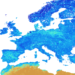
Soil water content (volumetric %) for 33kPa and 1500kPa suctions predicted at 6 standard depths (0, 10, 30, 60, 100 and 200 cm) at 250 m resolution
Training points are based on a global compilation of soil profiles:
Data import steps are available here. Spatial prediction steps are described in detail here. Note: these are actually measured and mapped soil content values; no Pedo-Transfer-Functions have been used (except to fill in the missing NCSS bulk densities). Available water capacity in mm (derived as a difference between field capacity and wilting point multiplied by layer thickness) per layer is available here. Antarctica is not included.
To access and visualize maps outside of Earth Engine, use this page.
If you discover a bug, artifact or inconsistency in the LandGIS maps or if you have a question please use the following channels:
Bands
Bands
Pixel size: 250 meters (all bands)
| Name | Units | Min | Max | Pixel Size | Description |
|---|---|---|---|---|---|
b0 |
% | 0* | 52.974* | 250 meters | Soil water content at 33kPa (field capacity) at 0 cm depth |
b10 |
% | 0* | 52.974* | 250 meters | Soil water content at 33kPa (field capacity) at 10 cm depth |
b30 |
% | 0* | 52.974* | 250 meters | Soil water content at 33kPa (field capacity) at 30 cm depth |
b60 |
% | 0* | 52.974* | 250 meters | Soil water content at 33kPa (field capacity) at 60 cm depth |
b100 |
% | 0* | 52.974* | 250 meters | Soil water content at 33kPa (field capacity) at 100 cm depth |
b200 |
% | 0* | 52.974* | 250 meters | Soil water content at 33kPa (field capacity) at 200 cm depth |
Terms of Use
Terms of Use
Citations
Tomislav Hengl, & Surya Gupta. (2019). Soil water content (volumetric %) for 33kPa and 1500kPa suctions predicted at 6 standard depths (0, 10, 30, 60, 100 and 200 cm) at 250 m resolution (Version v01) [Data set]. Zenodo. 10.5281/zenodo.2629589
DOIs
Explore with Earth Engine
Code Editor (JavaScript)
var dataset = ee.Image('OpenLandMap/SOL/SOL_WATERCONTENT-33KPA_USDA-4B1C_M/v01');

var visualization = {
  bands: ['b0'],
  min: 0.0,
  max: 52.9740182135385,
  palette: [
    'd29642','eec764','b4ee87','32eeeb','0c78ee','2601b7',
    '083371',
  ]
};

Map.centerObject(dataset);

Map.addLayer(dataset, visualization, 'Soil water content at 33kPa (field capacity)');