- 数据集可用性
- 2016-01-01T00:00:00Z–2017-01-02T00:00:00Z
- 数据集提供商
- 美国人口普查局
- 标签
说明
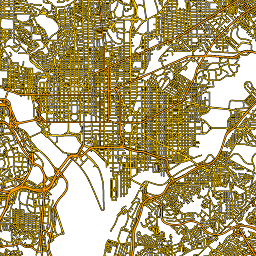
此美国人口普查局 TIGER 数据集包含 2016 年版本中的所有路段,其中包含超过 1,900 万个覆盖美国、哥伦比亚特区、波多黎各和岛屿地区的单独线要素。每个要素都表示一段道路几何图形(一条可通行的线性路径,至少与一个交叉路口相连)。
如需详细了解所有 TIGER 2016 产品,请参阅 TIGER 技术文档。
表架构
表架构
| 名称 | 类型 | 说明 |
|---|---|---|
| fullname | STRING | 简单易懂的道路名称 |
| linearid | STRING | 用于在其他 TIGER 产品中引用此行的主要标识符 |
| mtfcc | STRING | 道路优先代码,表示主干道、次干道、本地道路等。 |
| rttyp | STRING | 路线类型代码, |
使用条款
使用条款
美国人口调查局通过应用编程接口 (API) 以机器可读格式提供部分公开数据。通过 API 提供的所有内容、文档、代码和相关材料均受这些条款及条件的约束。
引用
引用:
对于因使用数据集而创建的任何报告、出版物、新数据集、衍生产品或服务,用户应引用美国人口普查局。
使用 Earth Engine 探索
代码编辑器 (JavaScript)
var dataset = ee.FeatureCollection('TIGER/2016/Roads');
var roads = dataset.style({color: '#4285F4', width: 1});
Map.setCenter(-73.99172, 40.74101, 12);
Map.addLayer(roads, {}, 'TIGER/2016/Roads');
以 FeatureView 形式直观呈现
FeatureView 是 FeatureCollection 的只读加速表示形式。如需了解详情,请访问
FeatureView 文档。
代码编辑器 (JavaScript)
var fvLayer = ui.Map.FeatureViewLayer('TIGER/2016/Roads_FeatureView');

var visParams = {
  color: '4285f4'
};

fvLayer.setVisParams(visParams);
fvLayer.setName('US census roads');

Map.setCenter(-73.99172, 40.74101, 14);
Map.add(fvLayer);
