-
全球 2020 年森林分类,用于 IPCC 地上生物质一级估算,V1

此数据集提供了 2020 年按状态/条件划分的全球森林类别,分辨率约为 30 米。这些数据有助于根据 2019 年修订版《2006 年 IPCC 国家温室气体清单指南》生成天然森林地上干木生物质密度 (AGBD) 的一级估算值。 地上 生物质 碳 分类 森林 森林生物质 -
全球地上和地下生物质碳密度地图

此数据集提供了 2010 年地上和地下生物质碳密度的时序一致且统一的全球地图,空间分辨率为 300 米。地上生物质地图集成了特定于土地覆盖类型的遥感地图,包括木本、草地、农田和苔原生物质。输入地图是 … 地上 生物质 碳 密度 森林 森林生物质 -
美国林务局 TreeMap v2020
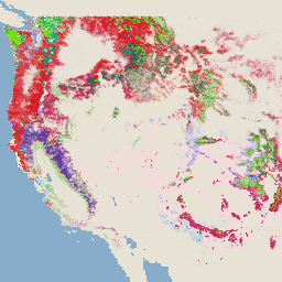
此产品是 TreeMap 数据套件的一部分。它提供了有关森林特征的详细空间信息,包括 2020 年美国整个森林覆盖范围内的活树和死树数量、生物质和碳。TreeMap v2020 包含 22 个波段,分辨率为 30 x 30 米 … 地上 生物质 碳 气候变化 conus 森林 -
美国林务局 TreeMap v2022

此产品是 TreeMap 数据套件的一部分。它提供了有关森林特征的详细空间信息,包括 2022 年美国整个森林覆盖范围内的活树和死树数量、生物质和碳。TreeMap v2022 包含 22 个波段,分辨率为 30 x 30 米 … 地上 生物质 碳 气候变化 conus 森林 -
WHRC 泛热带国家级碳储量数据集

热带国家/地区的地上活木生物质密度国家级地图,分辨率为 500 米。此数据集由共位实地测量、LiDAR 观测和中分辨率成像光谱仪 (MODIS) 记录的图像组合而成。 地上 生物质 碳 森林生物质 地球物理 umd
Datasets tagged aboveground in Earth Engine
[null,null,[],[],[]]