-
CryoSat-2 南极洲 1 公里 DEM
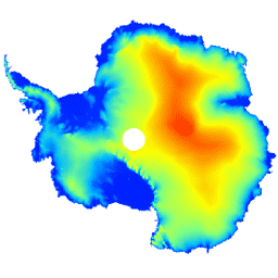
此数据集是南极冰盖和冰架的数字地形模型 (DEM),基于 CryoSat-2 卫星雷达高度计在 2010 年 7 月至 2016 年 7 月期间记录的观测数据。DEM 是通过对 1, … antarctica dem elevation elevation-topography polar -
南极洲 Landsat 图像拼接图 (LIMA) - 处理后的 Landsat 场景(16 位)
南极洲 Landsat 图像拼接图 (LIMA) 是根据经过处理的 Landsat 7 ETM+ 场景创建的几乎无云的流畅拼接图。处理后的 Landsat 场景(16 位)是指经过转换为 16 位、经太阳角度校正处理且转换为反射率值(Bindschadler … 南极洲 冰 Landsat 派生 气候 拼接图 卫星图像 -
南极洲 Landsat 图像拼接图 (LIMA) - 处理后的 Landsat 场景(16 位)元数据
南极洲 Landsat 图像拼接图 (LIMA) 是根据经过处理的 Landsat 7 ETM+ 场景创建的几乎无云的流畅拼接图。处理后的 Landsat 场景(16 位)是指经过转换为 16 位、经太阳角度校正处理且转换为反射率值(Bindschadler … 南极洲 冰 Landsat 派生 气候 拼接图 卫星图像 -
南极洲 Landsat 图像拼接图 (LIMA) 16 位全局锐化拼接图
南极洲 Landsat 图像拼接图 (LIMA) 是根据经过处理的 Landsat 7 ETM+ 场景创建的几乎无云的流畅拼接图。此 LIMA 数据集是 16 位中间 LIMA。该拼接图由经过平滑锐化处理的标准化地表反射率场景(Landsat ETM+ 波段 1、2、3 和… 南极洲 冰 Landsat 派生 气候 拼接图 卫星图像
Datasets tagged antarctica in Earth Engine
[null,null,[],[[["\u003cp\u003eCryoSat-2 Antarctica 1km DEM provides a digital elevation model of the Antarctic ice sheet and ice shelves based on CryoSat-2 satellite radar altimeter data from 2010 to 2016.\u003c/p\u003e\n"],["\u003cp\u003eThe Landsat Image Mosaic of Antarctica (LIMA) offers a seamless, cloudless mosaic created from processed Landsat 7 ETM+ scenes, available in 16-bit pan-sharpened and reflectance formats.\u003c/p\u003e\n"],["\u003cp\u003eLIMA datasets include processed Landsat scenes with sun-angle correction and reflectance values, along with corresponding metadata for detailed information about the scenes used in the mosaic.\u003c/p\u003e\n"]]],[],null,["# Datasets tagged antarctica in Earth Engine\n\n-\n\n |-------------------------------------------------------------------------------------------------------------------------------------------------------------------------------------------------------------------------------------------------------------------------------------------------------|\n | [### CryoSat-2 Antarctica 1km DEM](/earth-engine/datasets/catalog/CPOM_CryoSat2_ANTARCTICA_DEM) |\n | This dataset is a digital elevation model (DEM) of the Antarctic ice sheet and ice shelves based on observations recorded by the CryoSat-2 satellite radar altimeter between July 2010 and July 2016. The DEM is formed from spatio-temporal fits to elevation measurements accumulated within 1, ... |\n | [antarctica](/earth-engine/datasets/tags/antarctica) [dem](/earth-engine/datasets/tags/dem) [elevation](/earth-engine/datasets/tags/elevation) [elevation-topography](/earth-engine/datasets/tags/elevation-topography) [polar](/earth-engine/datasets/tags/polar) |\n\n-\n\n |-----------------------------------------------------------------------------------------------------------------------------------------------------------------------------------------------------------------------------------------------------------------------------------------------------------------------|\n | [### Landsat Image Mosaic of Antarctica (LIMA) - Processed Landsat Scenes (16 bit)](/earth-engine/datasets/catalog/USGS_LIMA_SR) |\n | The Landsat Image Mosaic of Antarctica (LIMA) is a seamless and virtually cloudless mosaic created from processed Landsat 7 ETM+ scenes. Processed Landsat Scenes (16 bit) are Level 1Gt NLAPS scenes converted to 16 bit, processed with sun-angle correction, and converted to reflectance values (Bindschadler ... |\n | [antarctica](/earth-engine/datasets/tags/antarctica) [ice](/earth-engine/datasets/tags/ice) [landsat-derived](/earth-engine/datasets/tags/landsat-derived) [lima](/earth-engine/datasets/tags/lima) [mosaic](/earth-engine/datasets/tags/mosaic) [satellite-imagery](/earth-engine/datasets/tags/satellite-imagery) |\n\n-\n\n |-----------------------------------------------------------------------------------------------------------------------------------------------------------------------------------------------------------------------------------------------------------------------------------------------------------------------|\n | [### Landsat Image Mosaic of Antarctica (LIMA) - Processed Landsat Scenes (16 bit) Metadata](/earth-engine/datasets/catalog/USGS_LIMA_SR_METADATA) |\n | The Landsat Image Mosaic of Antarctica (LIMA) is a seamless and virtually cloudless mosaic created from processed Landsat 7 ETM+ scenes. Processed Landsat Scenes (16 bit) are Level 1Gt NLAPS scenes converted to 16 bit, processed with sun-angle correction, and converted to reflectance values (Bindschadler ... |\n | [antarctica](/earth-engine/datasets/tags/antarctica) [ice](/earth-engine/datasets/tags/ice) [landsat-derived](/earth-engine/datasets/tags/landsat-derived) [lima](/earth-engine/datasets/tags/lima) [mosaic](/earth-engine/datasets/tags/mosaic) [satellite-imagery](/earth-engine/datasets/tags/satellite-imagery) |\n\n-\n\n |---------------------------------------------------------------------------------------------------------------------------------------------------------------------------------------------------------------------------------------------------------------------------------------------------------------------|\n | [### Landsat Image Mosaic of Antarctica (LIMA) 16-Bit Pan-Sharpened Mosaic](/earth-engine/datasets/catalog/USGS_LIMA_MOSAIC) |\n | The Landsat Image Mosaic of Antarctica (LIMA) is a seamless and virtually cloudless mosaic created from processed Landsat 7 ETM+ scenes. This LIMA dataset is the 16-bit Intermediate LIMA. The mosaic consists of pan-sharpened normalized surface reflectance scenes (Landsat ETM+ bands 1, 2, 3, and ... |\n | [antarctica](/earth-engine/datasets/tags/antarctica) [ice](/earth-engine/datasets/tags/ice) [landsat-derived](/earth-engine/datasets/tags/landsat-derived) [lima](/earth-engine/datasets/tags/lima) [mosaic](/earth-engine/datasets/tags/mosaic) [satellite-imagery](/earth-engine/datasets/tags/satellite-imagery) |"]]