-
澳大利亚的实际蒸散量(CMRSET Landsat V2.2)

此数据集使用 CMRSET 算法提供澳大利亚的准确实际蒸散量(AET 或 ETa)。AET 波段(命名为“ETa”)包含 CMRSET 模型在该月所有无云 Landsat 观测中的平均每日值(在 AET 数据中以值 3 表示)。 农业 澳大利亚 csiro 蒸发 蒸发蒸腾 landsat-derived -
澳大利亚 5 米 DEM

澳大利亚的数字高程模型 (DEM) 5 米网格源自 LiDAR 模型,表示一个国家级 5 米(裸地)DEM,该模型源自 2001 年至 2015 年间进行的约 236 次单独 LiDAR 调查,覆盖面积超过 245,000 平方公里。… 澳大利亚 dem elevation elevation-topography ga geophysical -
DEM-H:澳大利亚 SRTM 水文强制数字高程模型

水文强制数字高程模型 (DEM-H) 源自 NASA 于 2000 年 2 月获取的 SRTM 数据。模型已进行水文条件调整和排水强制处理。DEM-H 基于 SRTM 高程和已映射的河流线捕获水流路径,并支持划定… 澳大利亚 dem elevation elevation-topography ga geophysical -
DEM-S:澳大利亚平滑数字高程模型
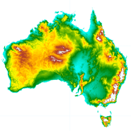
平滑数字高程模型 (DEM-S) 源自 NASA 于 2000 年 2 月获取的 SRTM 数据。DEM-S 表示地面地形(不包括植被特征),并且经过平滑处理,以减少噪声并改进地表形状的表示。一种自适应流程,应用了更多… 澳大利亚 dem elevation elevation-topography ga geophysical -
预览国家潮间带数字高程模型 25 米 1.0.0

国家潮间带数字高程模型 (NIDEM; Bishop-Taylor et al. 2018, 2019) 是澳大利亚裸露潮间带的大陆级高程数据集。NIDEM 首次以三维形式呈现了澳大利亚潮间带沙滩和海岸、潮滩以及岩石海岸和礁石,分辨率为 25 米… 澳大利亚 人口统计 海拔地形 GA -
SLGA:澳大利亚土壤和景观网格(土壤属性)

澳大利亚土壤和景观网格 (SLGA) 是一个全面的数据集,包含澳大利亚各地土壤属性,分辨率为 3 角秒(约 90 米像素)。这些面是根据现有土壤数据和环境数据,通过建模描述土壤属性的空间分布而得出的结果… 澳大利亚 CSIRO 土壤 TERN
Datasets tagged australia in Earth Engine
[null,null,[],[],["Several datasets provide detailed geographic and environmental information about Australia. Digital Elevation Models (DEMs) include a 5-meter grid from LiDAR surveys, a hydrologically enforced model, and a smoothed model from SRTM data, as well as a national intertidal DEM. Additional data includes the Soil and Landscape Grid of Australia (SLGA) with soil attributes. Landsat data is processed to show actual evapotranspiration (AET), land cover, water observations, and statistical analysis.\n"]]