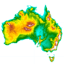
-
澳大利亚 5M DEM
从 LiDAR 模型派生的澳大利亚数字地形模型 (DEM) 5 米网格代表国家 5 米(裸地)DEM,该 DEM 是根据 2001 年至 2015 年期间约 236 项单独的 LiDAR 调查派生而来,覆盖面积超过 24.5 万平方公里。… 澳大利亚 dem elevation elevation-topography ga geophysical -
DEM-H:澳大利亚 SRTM 水文强制数字海拔模型
基于水文的数字海拔模型 (DEM-H) 派生自 NASA 在 2000 年 2 月获取的 SRTM 数据。该模型已进行水文条件化处理,并强制执行排水。DEM-H 基于 SRTM 海拔和已映射的河流线捕获流路径,并支持描绘… 澳大利亚 dem elevation elevation-topography ga geophysical -
DEM-S:澳大利亚平滑数字海拔模型
平滑数字海拔模型 (DEM-S) 派生自 NASA 在 2000 年 2 月获取的 SRTM 数据。DEM-S 表示地面表面地形(不包括植被地图项),并且已经过平滑处理以减少噪声并改进表面形状的表示。自适应流程会更 … 澳大利亚 dem elevation elevation-topography ga geophysical -
预览国家潮汐数字海拔模型 25 米 1.0.0
国家潮汐数字海拔模型 (NIDEM;Bishop-Taylor 等人,2018、2019) 是澳大利亚露出式潮汐区的大陆级海拔数据集。NIDEM 首次以三维方式呈现了澳大利亚的潮间沙滩和海岸、潮汐平原以及 25 米以下的岩石海岸和礁石。 australia dem elevation-topography ga
Datasets tagged ga in Earth Engine
[null,null,[],[[["\u003cp\u003eThis collection features a variety of Digital Elevation Models (DEMs) for Australia, including a 5-meter bare earth DEM derived from LiDAR and hydrologically enforced and smoothed DEMs derived from SRTM data.\u003c/p\u003e\n"],["\u003cp\u003eThe collection also includes a National Intertidal Digital Elevation Model (NIDEM) providing a 25-meter resolution representation of Australia's intertidal zones.\u003c/p\u003e\n"],["\u003cp\u003eSeveral datasets derived from Landsat imagery are available, offering insights into land cover, water observations, and statistical analysis of surface changes over time.\u003c/p\u003e\n"],["\u003cp\u003eThese datasets, produced by Geoscience Australia and Digital Earth Australia, provide valuable resources for environmental monitoring, resource management, and scientific research within Australia.\u003c/p\u003e\n"]]],["The datasets provide various models and data for Australia. These include Digital Elevation Models (DEMs) at 5m resolution from LiDAR surveys and hydrologically enforced/smoothed DEMs derived from SRTM data. The National Intertidal DEM represents Australia's intertidal zone at 25m. Also featured are Landsat-derived products like annual land cover classifications, water observation statistics, and geometric median/median absolute deviation datasets. These Landsat products utilize Landsat 5, 7, 8, and 9 data to provide insights into annual conditions and changes.\n"],null,["# Datasets tagged ga in Earth Engine\n\n-\n\n |-------------------------------------------------------------------------------------------------------------------------------------------------------------------------------------------------------------------------------------------------------------------------------------------------------------------|\n | [### Australian 5M DEM](/earth-engine/datasets/catalog/AU_GA_AUSTRALIA_5M_DEM) |\n | The Digital Elevation Model (DEM) 5 meter Grid of Australia derived from LiDAR model represents a National 5 meter (bare earth) DEM which has been derived from some 236 individual LiDAR surveys between 2001 and 2015 covering an area in excess of 245,000 square kilometers. ... |\n | [australia](/earth-engine/datasets/tags/australia) [dem](/earth-engine/datasets/tags/dem) [elevation](/earth-engine/datasets/tags/elevation) [elevation-topography](/earth-engine/datasets/tags/elevation-topography) [ga](/earth-engine/datasets/tags/ga) [geophysical](/earth-engine/datasets/tags/geophysical) |\n\n-\n\n |--------------------------------------------------------------------------------------------------------------------------------------------------------------------------------------------------------------------------------------------------------------------------------------------------------------------|\n | [### DEM-H: Australian SRTM Hydrologically Enforced Digital Elevation Model](/earth-engine/datasets/catalog/AU_GA_DEM_1SEC_v10_DEM-H) |\n | The Hydrologically Enforced Digital Elevation Model (DEM-H) was derived from the SRTM data acquired by NASA in February 2000. The model has been hydrologically conditioned and drainage enforced. The DEM-H captures flow paths based on SRTM elevations and mapped stream lines, and supports delineation of ... |\n | [australia](/earth-engine/datasets/tags/australia) [dem](/earth-engine/datasets/tags/dem) [elevation](/earth-engine/datasets/tags/elevation) [elevation-topography](/earth-engine/datasets/tags/elevation-topography) [ga](/earth-engine/datasets/tags/ga) [geophysical](/earth-engine/datasets/tags/geophysical) |\n\n-\n\n |-----------------------------------------------------------------------------------------------------------------------------------------------------------------------------------------------------------------------------------------------------------------------------------------------------------------------|\n | [### DEM-S: Australian Smoothed Digital Elevation Model](/earth-engine/datasets/catalog/AU_GA_DEM_1SEC_v10_DEM-S) |\n | The Smoothed Digital Elevation Model (DEM-S) was derived from the SRTM data acquired by NASA in February 2000. DEM-S represents ground surface topography (excluding vegetation features) and has been smoothed to reduce noise and improve the representation of surface shape. An adaptive process applied more ... |\n | [australia](/earth-engine/datasets/tags/australia) [dem](/earth-engine/datasets/tags/dem) [elevation](/earth-engine/datasets/tags/elevation) [elevation-topography](/earth-engine/datasets/tags/elevation-topography) [ga](/earth-engine/datasets/tags/ga) [geophysical](/earth-engine/datasets/tags/geophysical) |\n\n-\n\n |---------------------------------------------------------------------------------------------------------------------------------------------------------------------------------------------------------------------------------------------------------------------------------------------------------------------------------------------|\n | [### Preview National Intertidal Digital Elevation Model 25m 1.0.0](/earth-engine/datasets/catalog/projects_ngis-cat_assets_DEA_NIDEM) |\n | The National Intertidal Digital Elevation Model (NIDEM; Bishop-Taylor et al. 2018, 2019) is a continental-scale elevation dataset for Australia's exposed intertidal zone. NIDEM provides the first three-dimensional representation of Australia's intertidal sandy beaches and shores, tidal flats and rocky shores and reefs at 25 m ... |\n | [australia](/earth-engine/datasets/tags/australia) [dem](/earth-engine/datasets/tags/dem) [elevation-topography](/earth-engine/datasets/tags/elevation-topography) [ga](/earth-engine/datasets/tags/ga) |"]]