-
2000 年格陵兰镶嵌图 - 格陵兰冰层测绘项目 (GIMP)
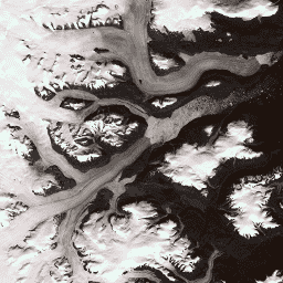
此数据集提供格陵兰冰盖的完整 15 米分辨率图像镶嵌,该镶嵌图源自 1999 年至 2002 年的 Landsat 7 ETM+ 和 RADARSAT-1 SAR 图像。这些方法包括图像云遮罩、全色锐化、图像采样和调整大小等技术的组合,… arctic gimp greenland imagery nasa polar -
ASTER L1T 辐射率

注意:由于 ASTER 仪器存在技术问题,2024 年 11 月 28 日至 2025 年 1 月 16 日期间的数据收集存在缺口。如需了解详情,请参阅美国地质调查局的公告。高级星载热发射和反射辐射计 (ASTER) 是一种多光谱成像仪,可… aster imagery nasa nir radiance satellite-imagery -
巴西森林图像数据集 2008:分析型基本地图

此数据集提供分辨率高达 10 米的巴西多光谱(绿、红和近红外)基本地图,主要拍摄于 2008 年,旨在支持《巴西森林法典》的实施。该镶嵌图由 SPOT 2、4 和 5 卫星数据合成。它可作为更高分辨率的… brazil forest-code google imagery multispectral satellite-imagery -
CCNL:DMSP-OLS(1992-2013 年)v1 版的一致且经过校正的夜间灯光数据集

“一致且校正后的夜间灯光”(CCNL) 数据集是国防气象计划 (DMSP) 业务线扫描系统 (OLS) 第 4 版的重新处理版本。我们采用了一系列方法来减轻年际不一致性、饱和度和光晕效应的影响,并提高数据… dmsp eog imagery lights nighttime ols -
DMSP OLS:全球辐射校准夜间灯光版本 4,国防气象计划业务线扫描系统

国防气象计划 (DMSP) 运行线扫描系统 (OLS) 具有独特的夜间检测可见光和近红外 (VNIR) 发射源的能力。此集合包含未出现传感器饱和的全球夜间灯光图像。传感器通常在高增益设置下运行,以实现… dmsp eog imagery lights nighttime ols -
DMSP OLS:夜间灯光时间序列版本 4,国防气象计划业务线扫描系统

国防气象计划 (DMSP) 运行线扫描系统 (OLS) 具有独特的夜间检测可见光和近红外 (VNIR) 发射源的能力。DMSP-OLS 夜间灯光时间序列第 4 版由使用所有可用的已归档 DMSP-OLS 平滑分辨率数据制作的无云合成数据组成… dmsp eog imagery lights nighttime ols -
NAIP:美国国家农业影像计划

美国国家农业影像计划 (NAIP) 在美国本土的农业生长季期间获取航空影像。NAIP 项目每年都会根据可用资金和影像采集周期签订合同。自 2003 年起,NAIP 以 5 年为周期进行采集。2008 年是… 农业 高分辨率 影像 正射影像 美国农业部 -
SPOT 全色图像 5-10 米,巴西

此集合包含 2008 年左右巴西的 SPOT 2、4 和 5 卫星原始全色 (PAN) 波段。全色传感器可提供任务的最高原生空间分辨率,可在较宽的可见光谱范围内(SPOT 2 为 0.51-0.73 微米,SPOT 4 为 0.61-0.68 微米,… brazil forest-code google imagery satellite-imagery spot
Datasets tagged imagery in Earth Engine
[null,null,[],[],[]]