-
USGS Landsat 7 级别 2、集合 2、第 1 层级
此数据集包含从 Landsat 7 ETM+ 传感器生成的数据派生出的经过大气校正的地表反射率和地表温度。这些图像包含 4 个可见光和近红外 (VNIR) 波段和 2 个短波红外 (SWIR) 波段,这些波段已处理为正射校正的表面反射率,以及 1 个热 … cfmask cloud etm fmask global landsat -
USGS Landsat 7 级别 2、集合 2、第 2 层级
此数据集包含从 Landsat 7 ETM+ 传感器生成的数据派生出的经过大气校正的地表反射率和地表温度。这些图像包含 4 个可见光和近红外 (VNIR) 波段和 2 个短波红外 (SWIR) 波段,这些波段已处理为正射校正的表面反射率,以及 1 个热 … cfmask cloud etm fmask global landsat
Datasets tagged le07 in Earth Engine
[null,null,[],[[["\u003cp\u003eThe datasets provide atmospherically corrected surface reflectance and land surface temperature data from the Landsat 7 ETM+ sensor.\u003c/p\u003e\n"],["\u003cp\u003eData includes visible, near-infrared, and short-wave infrared bands processed to orthorectified surface reflectance, along with thermal infrared data.\u003c/p\u003e\n"],["\u003cp\u003eBoth Tier 1 and Tier 2 datasets are derived from Landsat 7 ETM+ and share similar spectral and processing characteristics, primarily differing in data quality and cloud cover considerations.\u003c/p\u003e\n"]]],[],null,["# Datasets tagged le07 in Earth Engine\n\n-\n\n |-----------------------------------------------------------------------------------------------------------------------------------------------------------------------------------------------------------------------------------------------------------------------------------------------------------------------------------------|\n | [### USGS Landsat 7 Level 2, Collection 2, Tier 1
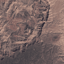
](/earth-engine/datasets/catalog/LANDSAT_LE07_C02_T1_L2) |\n | This dataset contains atmospherically corrected surface reflectance and land surface temperature derived from the data produced by the Landsat 7 ETM+ sensor. These images contain 4 visible and near-infrared (VNIR) bands and 2 short-wave infrared (SWIR) bands processed to orthorectified surface reflectance, and one thermal ... |\n | [cfmask](/earth-engine/datasets/tags/cfmask) [cloud](/earth-engine/datasets/tags/cloud) [etm](/earth-engine/datasets/tags/etm) [fmask](/earth-engine/datasets/tags/fmask) [global](/earth-engine/datasets/tags/global) [landsat](/earth-engine/datasets/tags/landsat) |\n\n-\n\n |-----------------------------------------------------------------------------------------------------------------------------------------------------------------------------------------------------------------------------------------------------------------------------------------------------------------------------------------|\n | [### USGS Landsat 7 Level 2, Collection 2, Tier 2](/earth-engine/datasets/catalog/LANDSAT_LE07_C02_T2_L2) |\n | This dataset contains atmospherically corrected surface reflectance and land surface temperature derived from the data produced by the Landsat 7 ETM+ sensor. These images contain 4 visible and near-infrared (VNIR) bands and 2 short-wave infrared (SWIR) bands processed to orthorectified surface reflectance, and one thermal ... |\n | [cfmask](/earth-engine/datasets/tags/cfmask) [cloud](/earth-engine/datasets/tags/cloud) [etm](/earth-engine/datasets/tags/etm) [fmask](/earth-engine/datasets/tags/fmask) [global](/earth-engine/datasets/tags/global) [landsat](/earth-engine/datasets/tags/landsat) |"]]