-
MERIT DEM:多重错误移除改进型地形 DEM
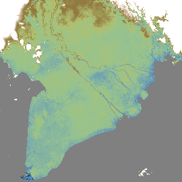
MERIT DEM 是一种高精度全球 DEM,分辨率为 3 弧秒(赤道处约为 90 米),通过消除现有 DEM(NASA SRTM3 DEM、JAXA AW3D DEM、Viewfinder Panoramas DEM)中的主要误差分量生成。MERIT DEM 可分离绝对偏差、条带噪声、斑点噪声和 … dem 海拔 海拔-地形 merit 地形 -
MERIT Hydro:全球水文数据集
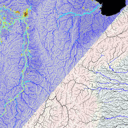
MERIT Hydro 是一张新的全球水流方向地图,分辨率为 3 角秒(赤道处约为 90 米),基于 MERIT DEM 海拔数据和水体数据集(G1WBM、GSWO 和 OpenStreetMap)的版本 1.0.3 派生而来。MERIT Hydro 包含新 … 的输出 dem elevation hydrography hydrosheds merit river-width -
MERIT Hydro:补充可视化图层

MERIT Hydro 的补充可视化图层 水文 HydroSHEDS MERIT 河宽 地表水和地下水 上游排水区
Datasets tagged merit in Earth Engine
[null,null,[],[],["MERIT DEM is a high-accuracy global Digital Elevation Model (DEM) with a 3 arc-second resolution. It was created by removing errors from existing DEMs. MERIT Hydro, derived from MERIT DEM, is a global flow direction map, also at 3 arc-second resolution, that uses water body datasets. Supplementary visualization layers for MERIT Hydro are also available. The main actions include the creation of these datasets and the enhancement of resolution and correction of errors.\n"]]