-
Farmscapes 2020
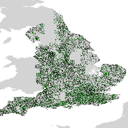
Farmscapes 2020 数据集提供了英格兰农业景观中三种关键半自然特征(树篱、林地和石墙)的高分辨率 (25 厘米) 概率地图。此数据集是与牛津大学 Leverhulme 自然恢复中心合作开发的,旨在作为应用的基础 … biodiversity climate conservation ecological-connectivity forest landuse-landcover -
Farmscapes 2020 矢量化

这是 Farmscapes 2020 栅格数据集的矢量化版本。它提供了多边形几何图形,用于表示英格兰农业景观中精细尺度的半自然景观特征(具体而言,是树篱、林地和石墙)。此数据集是与牛津大学 Leverhulme 自然恢复中心合作开发的,旨在 … biodiversity climate conservation ecological-connectivity forest landuse-landcover -
森林类型 (ForTy) 2020 v1.0

森林类型 (ForTy) v1 数据集包含 2020 年全球按类别划分的概率地图,分辨率为 10 米,涵盖南纬 65° 至北纬 84° 之间的所有陆地区域。六类类型与粮农组织和欧盟《零毁林法案》(EUDR) 的定义一致:第 1 类 … alphaearth-derived biodiversity climate conservation deforestation eudr -
2020 年世界天然森林

2020 年世界天然森林提供了 2020 年全球天然森林概率地图,分辨率为 10 米。此地图旨在支持《欧盟零毁林法案》(EUDR) 等倡议,以及其他森林保护和监测工作。该地图 … biodiversity climate conservation deforestation eudr forest -
物种分布,澳大利亚哺乳动物

这些物种分布模型输出由 Google 与 QCIF 和 EcoCommons 合作开发,表示对物种相对出现概率的估计(即,对于给定的调查方法和给定的调查 … alphaearth-derived biodiversity conservation ecosystems nature-trace publisher-dataset
Datasets tagged nature-trace in Earth Engine
[null,null,[],[],[]]