-
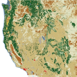
2020 年北美土地覆盖情况(30 米分辨率)

2020 年北美土地覆盖 30 米数据集是北美土地变化监测系统 (NALCMS) 的一部分,该系统是加拿大自然资源部、美国地质调查局和三个墨西哥组织(包括国家统计和地理研究所)之间的三边合作项目。 landcover landsat landuse-landcover nlcd reflectance -
NLCD 2019:美国地质调查局国家土地覆盖数据库,2019 年发布
NLCD(美国国家土地覆盖数据库)是一个基于 Landsat 的 30 米土地覆盖数据库,涵盖 8 个时间段(2001 年、2004 年、2006 年、2008 年、2011 年、2013 年、2016 年和 2019 年)。您还可以在此处找到 2021 年的第九个周期。这些图片依赖于不透水性数据层来显示城市… blm landcover landuse-landcover mrlc nlcd usgs -
NLCD 2021:美国地质调查局国家土地覆盖数据库,2021 年发布
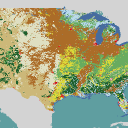
美国地质调查局 (USGS) 与多个联邦机构合作,现已开发并发布了七个国家土地覆盖数据库 (NLCD) 产品:NLCD 1992、2001、2006、2011、2016、2019 和 2021。自 2016 年发布以来,地表覆盖产品每隔 2-3 年创建一次… blm landcover landuse-landcover mrlc nlcd usgs -
RCMAP 草地分量时间序列(1985 年至 2023 年),版本 06

“RCMAP(草地状况监测评估和预测)数据集使用 1985 年至 2023 年的 Landsat 影像,量化了北美西部草地组成部分的覆盖百分比。RCMAP 产品套件包含 10 个分数组件:一年生草本、裸地、草本、凋落物、非山艾灌木、多年生草本、山艾灌木等。 climate-change disturbance landsat-derived landuse-landcover nlcd rangeland -
RCMAP 草地趋势年(1985-2023 年),v06

此合集包含 1985 年至 2023 年的 RCMAP 年度产品。RCMAP(牧草地状况监测评估和预测)数据集使用 1985 年至 2023 年的 Landsat 影像,量化了北美西部牧草地组成部分的覆盖百分比。RCMAP 产品套件包含 10 个分数组件:年限、… climate-change disturbance landsat-derived landuse-landcover nlcd rangeland -
RCMAP 草地分量时间序列趋势(1985 年至 2023 年),版本 06

RCMAP(牧草地状况监测评估和预测)数据集使用 1985 年至 2023 年的 Landsat 影像,量化了北美西部牧草地组成部分的覆盖百分比。RCMAP 产品套件包含 10 个分数组件:一年生草本、裸地、草本、凋落物、非山艾灌木、多年生草本、山艾灌木等。 climate-change disturbance landsat-derived landuse-landcover nlcd rangeland
Datasets tagged nlcd in Earth Engine
[null,null,[],[],[]]