-
GHSL:全球聚落特征(10 米)2018 年 (P2023A)
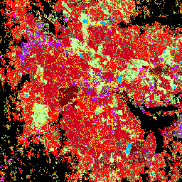
此空间栅格数据集以 10 米分辨率划定人类住区,并根据建成环境的功能和高度相关组成部分描述其内部特征。如需详细了解 GHSL 数据产品,请参阅 GHSL Data Package 2023 报告… 建筑物 建成区 建成区 哥白尼 ghsl 高度 -
TIGER:美国人口普查道路
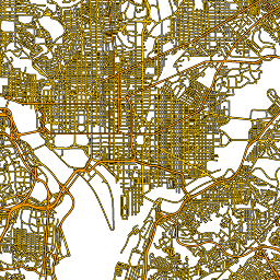
此美国人口普查局 TIGER 数据集包含 2016 年版本中的所有路段,其中包含超过 1,900 万个覆盖美国、哥伦比亚特区、波多黎各和岛屿地区的单独线要素。每个要素都表示一个路段几何图形(一个… census infrastructure-boundaries roads table tiger us
Datasets tagged roads in Earth Engine
[null,null,[],[],["The content describes two spatial datasets. The first, GHSL, delineates human settlements at 10m resolution, detailing functional and height-related aspects of the built environment. The second, TIGER, from the US Census Bureau, contains over 19 million road segments from the 2016 release, covering the US, District of Columbia, Puerto Rico, and Island Areas, each represented by a road segment geometry.\n"]]