-
ALOS-2 PALSAR-2 条状图层级 2.1
从 2024 年 1 月 1 日晚开始,JAXA 应日本各个部门和相关组织的要求,实施了 ALOS-2 PALSAR-2 应急观测。由于 JAXA 预计这些应急观测数据对灾害管理非常有用,因此 JAXA 决定在 … alos2 eroc jaxa palsar2 radar sar -
全球 3 类 PALSAR-2/PALSAR 森林/非森林地图
您可以在 JAXA/ALOS/PALSAR/YEARLY/FNF4 中找到此数据集的较新版本,其中包含 2017 年至 2020 年的 4 个类。全球森林/非森林地图 (FNF) 是通过对全球 25 米分辨率 PALSAR-2/PALSAR SAR 拼接图中的 SAR 图像(回波系数)进行分类而生成的,以便强回波像素和弱回波像素… alos alos2 classification eroc forest forest-biomass -
全球 4 类 PALSAR-2/PALSAR 森林/非森林地图
全球森林/非森林图 (FNF) 是通过对全球 25 米分辨率 PALSAR-2/PALSAR SAR 拼接图中的 SAR 图像(回波系数)进行分类而生成的,以便将强回波像素和弱回波像素分别分配为“森林”和“非森林”。在本指南中,“森林”是指具有以下特征的自然森林: alos alos2 classification eroc forest forest-biomass -
全球 PALSAR-2/PALSAR 年度拼接图,版本 1
您可以在 JAXA/ALOS/PALSAR/YEARLY/SAR_EPOCH 中找到包含 2015-2021 年数据的此数据集的较新版本。25 米分辨率的全球 PALSAR/PALSAR-2 拼接图是通过将 PALSAR/PALSAR-2 的 SAR 图像条拼接而成的无缝全球 SAR 图像。对于每个年份和地理位置,我们选择了条状数据… alos alos2 eroc jaxa palsar palsar2 -
全球 PALSAR-2/PALSAR 年度拼接图,版本 2
全球 25 米 PALSAR/PALSAR-2 拼接图是通过将 PALSAR/PALSAR-2 的 SAR 图像条拼接而成的无缝全球 SAR 图像。对于每个年份和地理位置,我们通过对相应时间段内可用的浏览拼接图进行目视检查,选择了显示最小 … alos alos2 eroc jaxa palsar palsar2 -
PALSAR-2 ScanSAR 级别 2.2
25 米 PALSAR-2 ScanSAR 是 PALSAR-2 大范围观测模式(观测宽度为 350 公里)的归一化回波数据。SAR 图像使用 ALOS World 3D - 30 米 (AW3D30) 数字地表模型进行了正射校正和坡度校正。偏振数据存储在… alos2 eroc jaxa palsar2 radar sar -
Sentinel-1 SAR GRD:C 频段合成孔径雷达地面距离检测,对数缩放
哨兵 1 号任务提供 5.405 GHz (C 频段) 双极化 C 频段合成孔径雷达 (SAR) 仪器的数据。此集合包含 S1 地面距离检测 (GRD) 场景,这些场景使用 Sentinel-1 工具箱处理后生成了经过校准和正射校正的产品。该合集每天更新一次。新建… copernicus esa eu radar sar satellite-imagery
Datasets tagged sar in Earth Engine
[null,null,[],[[["\u003cp\u003eThis page provides access to a variety of SAR datasets, including Sentinel-1 GRD, ALOS-2 PALSAR-2, and global PALSAR mosaics.\u003c/p\u003e\n"],["\u003cp\u003eSentinel-1 GRD offers dual-polarization C-band data, updated daily and processed for calibration and ortho-correction.\u003c/p\u003e\n"],["\u003cp\u003eALOS-2 PALSAR-2 datasets include StripMap and ScanSAR Level 2.1 and 2.2, featuring emergency observation data for disaster management.\u003c/p\u003e\n"],["\u003cp\u003eGlobal PALSAR-2/PALSAR datasets provide yearly mosaics and forest/non-forest maps at 25m resolution.\u003c/p\u003e\n"],["\u003cp\u003eJAXA (Japan Aerospace Exploration Agency) is the primary source for the ALOS and PALSAR datasets.\u003c/p\u003e\n"]]],[],null,["# Datasets tagged sar in Earth Engine\n\n-\n\n |--------------------------------------------------------------------------------------------------------------------------------------------------------------------------------------------------------------------------------------------------------------------------------------------------------------------------|\n | [### 
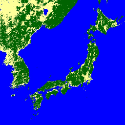
ALOS-2 PALSAR-2 StripMap Level 2.1](/earth-engine/datasets/catalog/JAXA_ALOS_PALSAR-2_Level2_1_StripMap_202401) |\n | Starting from the night of January 1st, 2024, based on the request from Japanese ministries and related organization, JAXA implemented ALOS-2 PALSAR-2 emergency observation. Since JAXA expects these emergency observation data to be extremely useful for disaster management, JAXA decided to open these data on ... |\n | [alos2](/earth-engine/datasets/tags/alos2) [eroc](/earth-engine/datasets/tags/eroc) [jaxa](/earth-engine/datasets/tags/jaxa) [palsar2](/earth-engine/datasets/tags/palsar2) [radar](/earth-engine/datasets/tags/radar) [sar](/earth-engine/datasets/tags/sar) |\n\n-\n\n |-------------------------------------------------------------------------------------------------------------------------------------------------------------------------------------------------------------------------------------------------------------------------------------------------------------------------------|\n | [### Global 3-class PALSAR-2/PALSAR Forest/Non-Forest Map](/earth-engine/datasets/catalog/JAXA_ALOS_PALSAR_YEARLY_FNF) |\n | A newer version of this dataset with 4 classes for 2017-2020 can be found in JAXA/ALOS/PALSAR/YEARLY/FNF4 The global forest/non-forest map (FNF) is generated by classifying the SAR image (backscattering coefficient) in the global 25m resolution PALSAR-2/PALSAR SAR mosaic so that strong and low backscatter pixels ... |\n | [alos](/earth-engine/datasets/tags/alos) [alos2](/earth-engine/datasets/tags/alos2) [classification](/earth-engine/datasets/tags/classification) [eroc](/earth-engine/datasets/tags/eroc) [forest](/earth-engine/datasets/tags/forest) [forest-biomass](/earth-engine/datasets/tags/forest-biomass) |\n\n-\n\n |-----------------------------------------------------------------------------------------------------------------------------------------------------------------------------------------------------------------------------------------------------------------------------------------------------------------------------------|\n | [### Global 4-class PALSAR-2/PALSAR Forest/Non-Forest Map](/earth-engine/datasets/catalog/JAXA_ALOS_PALSAR_YEARLY_FNF4) |\n | The global forest/non-forest map (FNF) is generated by classifying the SAR image (backscattering coefficient) in the global 25m resolution PALSAR-2/PALSAR SAR mosaic so that strong and low backscatter pixels are assigned as \"forest\" and \"non-forest\", respectively. Here, \"forest\" is defined as the natural forest with ... |\n | [alos](/earth-engine/datasets/tags/alos) [alos2](/earth-engine/datasets/tags/alos2) [classification](/earth-engine/datasets/tags/classification) [eroc](/earth-engine/datasets/tags/eroc) [forest](/earth-engine/datasets/tags/forest) [forest-biomass](/earth-engine/datasets/tags/forest-biomass) |\n\n-\n\n |---------------------------------------------------------------------------------------------------------------------------------------------------------------------------------------------------------------------------------------------------------------------------------------------------------------|\n | [### Global PALSAR-2/PALSAR Yearly Mosaic, version 1](/earth-engine/datasets/catalog/JAXA_ALOS_PALSAR_YEARLY_SAR) |\n | A newer version of this dataset with data for 2015-2021 can be found in JAXA/ALOS/PALSAR/YEARLY/SAR_EPOCH The global 25m PALSAR/PALSAR-2 mosaic is a seamless global SAR image created by mosaicking strips of SAR imagery from PALSAR/PALSAR-2. For each year and location, the strip data were selected ... |\n | [alos](/earth-engine/datasets/tags/alos) [alos2](/earth-engine/datasets/tags/alos2) [eroc](/earth-engine/datasets/tags/eroc) [jaxa](/earth-engine/datasets/tags/jaxa) [palsar](/earth-engine/datasets/tags/palsar) [palsar2](/earth-engine/datasets/tags/palsar2) |\n\n-\n\n |-----------------------------------------------------------------------------------------------------------------------------------------------------------------------------------------------------------------------------------------------------------------------------------------------------------|\n | [### Global PALSAR-2/PALSAR Yearly Mosaic, version 2](/earth-engine/datasets/catalog/JAXA_ALOS_PALSAR_YEARLY_SAR_EPOCH) |\n | The global 25m PALSAR/PALSAR-2 mosaic is a seamless global SAR image created by mosaicking strips of SAR imagery from PALSAR/PALSAR-2. For each year and location, the strip data were selected through visual inspection of the browse mosaics available over the period, with those showing minimum ... |\n | [alos](/earth-engine/datasets/tags/alos) [alos2](/earth-engine/datasets/tags/alos2) [eroc](/earth-engine/datasets/tags/eroc) [jaxa](/earth-engine/datasets/tags/jaxa) [palsar](/earth-engine/datasets/tags/palsar) [palsar2](/earth-engine/datasets/tags/palsar2) |\n\n-\n\n |------------------------------------------------------------------------------------------------------------------------------------------------------------------------------------------------------------------------------------------------------------------------------------------------|\n | [### 
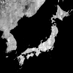
PALSAR-2 ScanSAR Level 2.2](/earth-engine/datasets/catalog/JAXA_ALOS_PALSAR-2_Level2_2_ScanSAR) |\n | The 25 m PALSAR-2 ScanSAR is normalized backscatter data of PALSAR-2 broad area observation mode with observation width of 350 km. The SAR imagery was ortho-rectificatied and slope corrected using the ALOS World 3D - 30 m (AW3D30) Digital Surface Model. Polarization data are stored ... |\n | [alos2](/earth-engine/datasets/tags/alos2) [eroc](/earth-engine/datasets/tags/eroc) [jaxa](/earth-engine/datasets/tags/jaxa) [palsar2](/earth-engine/datasets/tags/palsar2) [radar](/earth-engine/datasets/tags/radar) [sar](/earth-engine/datasets/tags/sar) |\n\n-\n\n |---------------------------------------------------------------------------------------------------------------------------------------------------------------------------------------------------------------------------------------------------------------------------------------------------------------------------------------------|\n | [### Sentinel-1 SAR GRD: C-band Synthetic Aperture Radar Ground Range Detected, log scaling](/earth-engine/datasets/catalog/COPERNICUS_S1_GRD) |\n | The Sentinel-1 mission provides data from a dual-polarization C-band Synthetic Aperture Radar (SAR) instrument at 5.405GHz (C band). This collection includes the S1 Ground Range Detected (GRD) scenes, processed using the Sentinel-1 Toolbox to generate a calibrated, ortho-corrected product. The collection is updated daily. New ... |\n | [copernicus](/earth-engine/datasets/tags/copernicus) [esa](/earth-engine/datasets/tags/esa) [eu](/earth-engine/datasets/tags/eu) [radar](/earth-engine/datasets/tags/radar) [sar](/earth-engine/datasets/tags/sar) [satellite-imagery](/earth-engine/datasets/tags/satellite-imagery) |"]]