-
DEM-H:澳大利亚 SRTM 水文强制数字高程模型

水文强制数字高程模型 (DEM-H) 源自 NASA 于 2000 年 2 月获取的 SRTM 数据。模型已进行水文条件调整和排水强制处理。DEM-H 基于 SRTM 高程和已映射的河流线捕获水流路径,并支持划定… 澳大利亚 dem elevation elevation-topography ga geophysical -
DEM-S:澳大利亚平滑数字高程模型
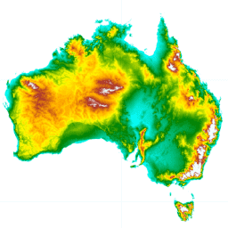
平滑数字高程模型 (DEM-S) 源自 NASA 于 2000 年 2 月获取的 SRTM 数据。DEM-S 表示地面地形(不包括植被特征),并且经过平滑处理,以减少噪声并改进地表形状的表示。一种自适应流程,应用了更多… 澳大利亚 dem elevation elevation-topography ga geophysical
Datasets tagged smoothed in Earth Engine
[null,null,[],[],[]]