-
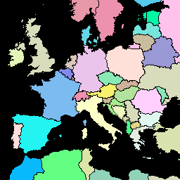
FAO GAUL 500m Simplified: Global Administrative Unit Layers 2015, Country Boundaries

此版本的 GAUL 数据集已简化为 500 米。全球行政区划层 (GAUL) 汇编并传播有关世界各国行政区划的最佳可用信息,有助于实现表示行政区划的空间数据集的标准化。… 边界 国家/地区 fao gaul infrastructure-boundaries 表格 -
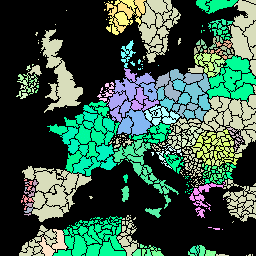
FAO GAUL 500m Simplified: Global Administrative Unit Layers 2015, First-Level Administrative Units

此版本的 GAUL 数据集已简化为 500 米。全球行政区划层 (GAUL) 汇编并传播有关世界各国行政区划的最佳可用信息,有助于实现表示行政区划的空间数据集的标准化。… 边界 部门 fao gaul infrastructure-boundaries 省份 -
FAO GAUL 500m Simplified:全球行政单位层 2015 年,二级行政单位

此版本的 GAUL 数据集已简化为 500 米。全球行政区划层 (GAUL) 汇编并传播有关世界各国行政区划的最佳可用信息,有助于实现表示行政区划的空间数据集的标准化。… 边界 县 行政区 粮农组织 GAUL 基础设施边界 -
FAO GAUL:全球行政单位图层 2015 年版,国家/地区边界
全球行政区划层 (GAUL) 汇编并传播有关世界各国行政区划的最佳可用信息,有助于实现表示行政区划的空间数据集的标准化。GAUL 始终维护具有统一 … 的全球图层 边界 国家/地区 fao gaul infrastructure-boundaries 表格 -
FAO GAUL:2015 年全球行政区划层级,一级行政区
全球行政区划层 (GAUL) 汇编并传播有关世界各国行政区划的最佳可用信息,有助于实现表示行政区划的空间数据集的标准化。GAUL 始终维护具有统一 … 的全球图层 边界 部门 fao gaul infrastructure-boundaries 省份 -
FAO GAUL:全球行政区划层级 2015 年,二级行政区

全球行政区划层 (GAUL) 汇编并传播有关世界各国行政区划的最佳可用信息,有助于实现表示行政区划的空间数据集的标准化。GAUL 始终维护具有统一 … 的全球图层 边界 县 行政区 粮农组织 GAUL 基础设施边界
Datasets tagged un in Earth Engine
[null,null,[],[],[]]