Elemento de elevação
Mantenha tudo organizado com as coleções
Salve e categorize o conteúdo com base nas suas preferências.
 Elemento autônomo de elevação
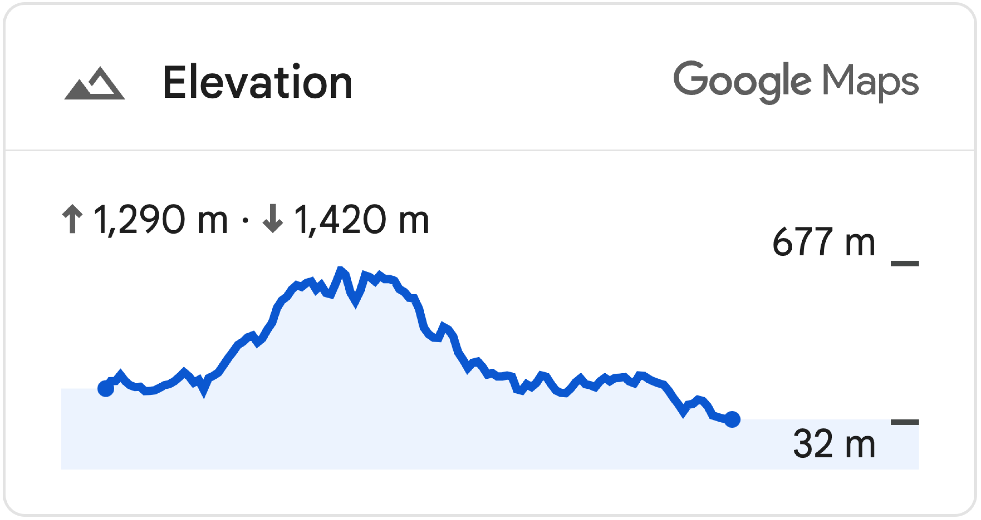
O
ElevationElement é um elemento HTML que mostra visualmente os dados de elevação de um único ponto ou de uma polilinha. Ele mostra um gráfico de elevação ao longo do caminho definido na propriedade
path com uma matriz de coordenadas de latitude e longitude. Os segmentos de linha são interpolados entre os pontos da matriz. Portanto, mesmo um pequeno número de pontos ainda vai produzir um gráfico de elevação detalhado.
Definir a elevação do caminho usando coordenadas
O exemplo a seguir renderiza a elevação de um caminho entre dois pontos selecionados por um conjunto de coordenadas, usando um elemento gmp-elevation.
O elemento é configurado para medição de métricas usando o atributo
unit-system:
<gmp-elevation unit-system="metric"></gmp-elevation>
Um querySelector é usado para selecionar o elemento de elevação e definir a propriedade path com coordenadas de latitude e longitude:
/** Maps JS loaded callback */
async function init() {
  // Load the Elevation Element from Maps JS
  const {ElevationElement} = await google.maps.importLibrary('elevation');

  // Specify an elevation path to render
  const elevationElement = document.querySelector('gmp-elevation');
  elevationElement.path = [
    {lat: 37.4523, lng: -122.2645},
    {lat: 37.377, lng: -122.4078},
  ];
}
Confira o exemplo de código completo
JavaScript
/** Maps JS loaded callback */
async function init() {
  // Load the Elevation Element from Maps JS
  const {ElevationElement} = await google.maps.importLibrary('elevation');

  // Specify an elevation path to render
  const elevationElement = document.querySelector('gmp-elevation');
  elevationElement.path = [
    {lat: 37.4523, lng: -122.2645},
    {lat: 37.377, lng: -122.4078},
  ];
}

init();
CSS
html, body {
  margin: 0;
  padding: 0;
}

gmp-elevation {
  width: 100%;
  height: 100%;
}

.overlay {
  margin: 20px;
  width: 400px;
}
HTML
<!DOCTYPE html>
<html>
  <head>
    <title>Simple Elevation</title>
    <meta charset="utf-8">
    <link rel="stylesheet" type="text/css" href="style.css">
  </head>
  <body>
    <h1>Path elevation</h1>
        <div class="overlay">
          <gmp-elevation unit-system="metric"></gmp-elevation>
        </div>
    <script>
      (g=>{var h,a,k,p="The Google Maps JavaScript API",c="google",l="importLibrary",q="__ib__",m=document,b=window;b=b[c]||(b[c]={});var d=b.maps||(b.maps={}),r=new Set,e=new URLSearchParams,u=()=>h||(h=new Promise(async(f,n)=>{await (a=m.createElement("script"));e.set("libraries",[...r]+"");for(k in g)e.set(k.replace(/[A-Z]/g,t=>"_"+t[0].toLowerCase()),g[k]);e.set("callback",c+".maps."+q);a.src=`https://maps.${c}apis.com/maps/api/js?`+e;d[q]=f;a.onerror=()=>h=n(Error(p+" could not load."));a.nonce=m.querySelector("script[nonce]")?.nonce||"";m.head.append(a)}));d[l]?console.warn(p+" only loads once. Ignoring:",g):d[l]=(f,...n)=>r.add(f)&&u().then(()=>d[l](f,...n))})({
        key: "YOUR_API_KEY",
        v: "alpha"
      });
    </script>
  </body>
</html>
Definir a elevação do caminho usando uma polilinha
O exemplo a seguir renderiza a elevação de um caminho com base em uma polilinha desenhada pelo usuário. Ele recebe o
path da poligonal do usuário usando polyline.getPath().getArray():
elevationElem.path = polyline.getPath().getArray();
Confira o exemplo de código completo
JavaScript
const map = document.querySelector('gmp-map');
const elevationElem = document.querySelector('gmp-elevation');

async function init() {
  await google.maps.importLibrary('places');
  await google.maps.importLibrary('marker');
  await google.maps.importLibrary('elevation');


  map.innerMap.setOptions({'mapTypeControl': true, 'clickableIcons': false});

  findCurrentLocation();
  drawPolyline();
}

async function drawPolyline() {
  const {DrawingManager} = await google.maps.importLibrary('drawing');
  const drawingManager = new DrawingManager({
    drawingMode: google.maps.drawing.OverlayType.POLYLINE,
    drawingControl: true,
    drawingControlOptions: {
      position: google.maps.ControlPosition.TOP_CENTER,
      drawingModes: [google.maps.drawing.OverlayType.POLYLINE]
    },
    polylineOptions: {geodesic: true, strokeColor: '#5491f5', strokeWeight: 6}
  });

  drawingManager.setMap(map.innerMap);

  drawingManager.addListener('polylinecomplete', (polyline) => {
    console.log('complete');
    console.log(polyline.getPath().getArray());
    elevationElem.path = polyline.getPath().getArray();
    polyline.addListener('click', (e) => {
      console.log(e);
    });
  });
}

async function findCurrentLocation() {
  const {LatLng} = await google.maps.importLibrary('core');
  if (navigator.geolocation) {
    navigator.geolocation.getCurrentPosition(
        (position) => {
          const pos =
              new LatLng(position.coords.latitude, position.coords.longitude);
          map.innerMap.panTo(pos);
          map.innerMap.setZoom(16);
        },
        () => {
          console.log('The Geolocation service failed.');
          map.innerMap.setZoom(16);
        },
    );
  } else {
    console.log(`Your browser doesn't support geolocation`);
    map.innerMap.setZoom(16);
  }
}

init();
CSS
html, body {
    height: 100%;
    margin: 0;
}

body {
    display: flex;
    flex-direction: column;
    font-family: Arial, Helvetica, sans-serif;
}

h1 {
    font-size: 16px;
    text-align: center;
}

gmp-map {
    box-sizing: border-box;
    margin-top: 20px;
    width: 100%;
    height: 100%;
}

gmp-elevation {
    width: 100%;
    height: 300px;
}

.overlay {
    width: 800px;
}
HTML
<!DOCTYPE html>
<html>
  <head>
    <title>Path Elevation</title>
    <meta charset="utf-8">
    <link rel="stylesheet" type="text/css" href="style.css">
  </head>
  <body>
    <h1>Draw polyline and get path elevation</h1>
    <gmp-map center="-37.813,144.963" zoom="12" map-id="DEMO_MAP_ID">
        <div id="elevation-container" class="overlay" slot="control-block-end-inline-center">
          <gmp-elevation unit-system="metric"></gmp-elevation>
        </div>
    </gmp-map>
    <script>
      (g=>{var h,a,k,p="The Google Maps JavaScript API",c="google",l="importLibrary",q="__ib__",m=document,b=window;b=b[c]||(b[c]={});var d=b.maps||(b.maps={}),r=new Set,e=new URLSearchParams,u=()=>h||(h=new Promise(async(f,n)=>{await (a=m.createElement("script"));e.set("libraries",[...r]+"");for(k in g)e.set(k.replace(/[A-Z]/g,t=>"_"+t[0].toLowerCase()),g[k]);e.set("callback",c+".maps."+q);a.src=`https://maps.${c}apis.com/maps/api/js?`+e;d[q]=f;a.onerror=()=>h=n(Error(p+" could not load."));a.nonce=m.querySelector("script[nonce]")?.nonce||"";m.head.append(a)}));d[l]?console.warn(p+" only loads once. Ignoring:",g):d[l]=(f,...n)=>r.add(f)&&u().then(()=>d[l](f,...n))})({
        key: "YOUR_API_KEY",
        v: "alpha"
      });
    </script>
  </body>
</html>
Exceto em caso de indicação contrária, o conteúdo desta página é licenciado de acordo com a Licença de atribuição 4.0 do Creative Commons, e as amostras de código são licenciadas de acordo com a Licença Apache 2.0. Para mais detalhes, consulte as políticas do site do Google Developers. Java é uma marca registrada da Oracle e/ou afiliadas.
Última atualização 2025-06-05 UTC.
[null,null,["Última atualização 2025-06-05 UTC."],[[["\u003cp\u003eThe \u003ccode\u003eElevationElement\u003c/code\u003e displays elevation data for a point or polyline on a map using a graph.\u003c/p\u003e\n"],["\u003cp\u003eYou can set the elevation path using latitude and longitude coordinates or with a user-drawn polyline.\u003c/p\u003e\n"],["\u003cp\u003eThe elevation graph is generated by interpolating line segments between the provided coordinates.\u003c/p\u003e\n"],["\u003cp\u003eThis feature is currently experimental and might have limited support.\u003c/p\u003e\n"]]],["The `ElevationElement` visually displays elevation data for a point or polyline. It uses a `gmp-elevation` element configured for metric measurements. Elevation paths can be set via coordinates or a user-drawn polyline. When using coordinates, a `querySelector` selects the element, and the `path` property is set with latitude/longitude arrays. For polylines, the element's `path` is populated using `polyline.getPath().getArray()`, to get an array of the polyline's coordinates. This feature is currently in an experimental pre-GA stage.\n"],null,["| This product or feature is Experimental (pre-GA). Pre-GA products and features might have limited support, and changes to pre-GA products and features might not be compatible with other pre-GA versions. Pre-GA Offerings are covered by the [Google\n| Maps Platform Service Specific Terms](https://cloud.google.com/maps-platform/terms/maps-service-terms). For more information, see the [launch stage descriptions](/maps/launch-stages).\nElevation Standalone Element\n\nThe [`ElevationElement`](/maps/documentation/javascript/reference/elevation-widget#ElevationElement) is an HTML element that visually displays elevation data for a single point or a polyline. It shows a graph of elevation along the path set in the [`path`](/maps/documentation/javascript/reference/elevation-widget#ElevationElement.path) property with an array of latitude and longitude coordinates. Line segments are interpolated between the points of the array, so even a small number of points will still produce a detailed elevation graph.\n\nSet path elevation using coordinates\n\nThe following example renders the elevation of a path between two points selected by a set of coordinates, using a `gmp-elevation` element.\n\nThe element is configured for metric measurement using the [`unit-system`](/maps/documentation/javascript/reference/elevation-widget#ElevationElement.unitSystem) attribute: \n\n```html\n \u003cgmp-elevation unit-system=\"metric\"\u003e\u003c/gmp-elevation\u003e\n```\n\nA `querySelector` is used to select the elevation element and set its `path` property with latitude and longitude coordinates: \n\n```javascript\n/** Maps JS loaded callback */\nasync function init() {\n // Load the Elevation Element from Maps JS\n const {ElevationElement} = await google.maps.importLibrary('elevation');\n\n // Specify an elevation path to render\n const elevationElement = document.querySelector('gmp-elevation');\n elevationElement.path = [\n {lat: 37.4523, lng: -122.2645},\n {lat: 37.377, lng: -122.4078},\n ];\n}\n```\n\nSee the complete code example \n\nJavaScript \n\n```javascript\n/** Maps JS loaded callback */\nasync function init() {\n // Load the Elevation Element from Maps JS\n const {ElevationElement} = await google.maps.importLibrary('elevation');\n\n // Specify an elevation path to render\n const elevationElement = document.querySelector('gmp-elevation');\n elevationElement.path = [\n {lat: 37.4523, lng: -122.2645},\n {lat: 37.377, lng: -122.4078},\n ];\n}\n\ninit();\n```\n\nCSS \n\n```css\nhtml, body {\n margin: 0;\n padding: 0;\n}\n\ngmp-elevation {\n width: 100%;\n height: 100%;\n}\n\n.overlay {\n margin: 20px;\n width: 400px;\n}\n```\n\nHTML \n\n```html\n\u003c!DOCTYPE html\u003e\n\u003chtml\u003e\n \u003chead\u003e\n \u003ctitle\u003eSimple Elevation\u003c/title\u003e\n \u003cmeta charset=\"utf-8\"\u003e\n \u003clink rel=\"stylesheet\" type=\"text/css\" href=\"style.css\"\u003e\n \u003c/head\u003e\n \u003cbody\u003e\n \u003ch1\u003ePath elevation\u003c/h1\u003e\n \u003cdiv class=\"overlay\"\u003e\n \u003cgmp-elevation unit-system=\"metric\"\u003e\u003c/gmp-elevation\u003e\n \u003c/div\u003e\n \u003cscript\u003e\n (g=\u003e{var h,a,k,p=\"The Google Maps JavaScript API\",c=\"google\",l=\"importLibrary\",q=\"__ib__\",m=document,b=window;b=b[c]||(b[c]={});var d=b.maps||(b.maps={}),r=new Set,e=new URLSearchParams,u=()=\u003eh||(h=new Promise(async(f,n)=\u003e{await (a=m.createElement(\"script\"));e.set(\"libraries\",[...r]+\"\");for(k in g)e.set(k.replace(/[A-Z]/g,t=\u003e\"_\"+t[0].toLowerCase()),g[k]);e.set(\"callback\",c+\".maps.\"+q);a.src=`https://maps.${c}apis.com/maps/api/js?`+e;d[q]=f;a.onerror=()=\u003eh=n(Error(p+\" could not load.\"));a.nonce=m.querySelector(\"script[nonce]\")?.nonce||\"\";m.head.append(a)}));d[l]?console.warn(p+\" only loads once. Ignoring:\",g):d[l]=(f,...n)=\u003er.add(f)&&u().then(()=\u003ed[l](f,...n))})({\n key: \"YOUR_API_KEY\",\n v: \"alpha\"\n });\n \u003c/script\u003e\n \u003c/body\u003e\n\u003c/html\u003e\n```\n\nSet path elevation using a polyline\n\nThe following example renders the elevation of a path based on a user-drawn polyline. It obtains the [`path`](/maps/documentation/javascript/reference/elevation-widget#ElevationElement.path) from the user's polyline using [`polyline.getPath().getArray()`:](/maps/documentation/javascript/reference/polygon#Polyline.getPath) \n\n```javascript\n elevationElem.path = polyline.getPath().getArray();\n```\n\nSee the complete code example \n\nJavaScript \n\n```javascript\nconst map = document.querySelector('gmp-map');\nconst elevationElem = document.querySelector('gmp-elevation');\n\nasync function init() {\n await google.maps.importLibrary('places');\n await google.maps.importLibrary('marker');\n await google.maps.importLibrary('elevation');\n\n\n map.innerMap.setOptions({'mapTypeControl': true, 'clickableIcons': false});\n\n findCurrentLocation();\n drawPolyline();\n}\n\nasync function drawPolyline() {\n const {DrawingManager} = await google.maps.importLibrary('drawing');\n const drawingManager = new DrawingManager({\n drawingMode: google.maps.drawing.OverlayType.POLYLINE,\n drawingControl: true,\n drawingControlOptions: {\n position: google.maps.ControlPosition.TOP_CENTER,\n drawingModes: [google.maps.drawing.OverlayType.POLYLINE]\n },\n polylineOptions: {geodesic: true, strokeColor: '#5491f5', strokeWeight: 6}\n });\n\n drawingManager.setMap(map.innerMap);\n\n drawingManager.addListener('polylinecomplete', (polyline) =\u003e {\n console.log('complete');\n console.log(polyline.getPath().getArray());\n elevationElem.path = polyline.getPath().getArray();\n polyline.addListener('click', (e) =\u003e {\n console.log(e);\n });\n });\n}\n\nasync function findCurrentLocation() {\n const {LatLng} = await google.maps.importLibrary('core');\n if (navigator.geolocation) {\n navigator.geolocation.getCurrentPosition(\n (position) =\u003e {\n const pos =\n new LatLng(position.coords.latitude, position.coords.longitude);\n map.innerMap.panTo(pos);\n map.innerMap.setZoom(16);\n },\n () =\u003e {\n console.log('The Geolocation service failed.');\n map.innerMap.setZoom(16);\n },\n );\n } else {\n console.log(`Your browser doesn't support geolocation`);\n map.innerMap.setZoom(16);\n }\n}\n\ninit();\n```\n\nCSS \n\n```css\nhtml, body {\n height: 100%;\n margin: 0;\n}\n\nbody {\n display: flex;\n flex-direction: column;\n font-family: Arial, Helvetica, sans-serif;\n}\n\nh1 {\n font-size: 16px;\n text-align: center;\n}\n\ngmp-map {\n box-sizing: border-box;\n margin-top: 20px;\n width: 100%;\n height: 100%;\n}\n\ngmp-elevation {\n width: 100%;\n height: 300px;\n}\n\n.overlay {\n width: 800px;\n}\n```\n\nHTML \n\n```html\n\u003c!DOCTYPE html\u003e\n\u003chtml\u003e\n \u003chead\u003e\n \u003ctitle\u003ePath Elevation\u003c/title\u003e\n \u003cmeta charset=\"utf-8\"\u003e\n \u003clink rel=\"stylesheet\" type=\"text/css\" href=\"style.css\"\u003e\n \u003c/head\u003e\n \u003cbody\u003e\n \u003ch1\u003eDraw polyline and get path elevation\u003c/h1\u003e\n \u003cgmp-map center=\"-37.813,144.963\" zoom=\"12\" map-id=\"DEMO_MAP_ID\"\u003e\n \u003cdiv id=\"elevation-container\" class=\"overlay\" slot=\"control-block-end-inline-center\"\u003e\n \u003cgmp-elevation unit-system=\"metric\"\u003e\u003c/gmp-elevation\u003e\n \u003c/div\u003e\n \u003c/gmp-map\u003e\n \u003cscript\u003e\n (g=\u003e{var h,a,k,p=\"The Google Maps JavaScript API\",c=\"google\",l=\"importLibrary\",q=\"__ib__\",m=document,b=window;b=b[c]||(b[c]={});var d=b.maps||(b.maps={}),r=new Set,e=new URLSearchParams,u=()=\u003eh||(h=new Promise(async(f,n)=\u003e{await (a=m.createElement(\"script\"));e.set(\"libraries\",[...r]+\"\");for(k in g)e.set(k.replace(/[A-Z]/g,t=\u003e\"_\"+t[0].toLowerCase()),g[k]);e.set(\"callback\",c+\".maps.\"+q);a.src=`https://maps.${c}apis.com/maps/api/js?`+e;d[q]=f;a.onerror=()=\u003eh=n(Error(p+\" could not load.\"));a.nonce=m.querySelector(\"script[nonce]\")?.nonce||\"\";m.head.append(a)}));d[l]?console.warn(p+\" only loads once. Ignoring:\",g):d[l]=(f,...n)=\u003er.add(f)&&u().then(()=\u003ed[l](f,...n))})({\n key: \"YOUR_API_KEY\",\n v: \"alpha\"\n });\n \u003c/script\u003e\n \u003c/body\u003e\n\u003c/html\u003e\n```"]]