
控件概览
通过 Maps JavaScript API 中的 3D 地图显示的地图包含界面元素(称为 探索控件),以支持用户与地图互动。探索控件默认显示在地图界面中,但可以停用,以简化界面或为自定义控件留出空间。请注意,停用界面控件后,可以使用地图探索键盘快捷键。
Maps JavaScript API 中的 3D 地图还支持使用预设的镜头路径引导用户浏览地图。您可以自定义和组合这些路径,以打造丰富的 3D 体验。
探索控件
下图显示了 Maps JavaScript API 中的 3D 地图会默认显示的一组控件:
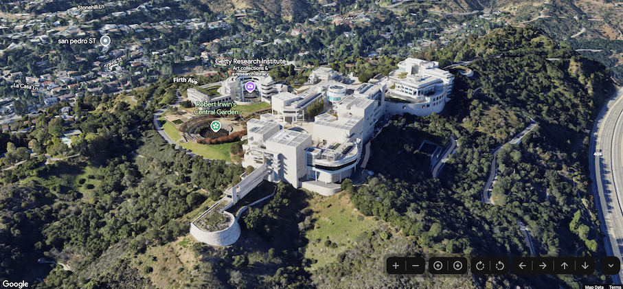
下面列出了一整套可在 Maps JavaScript 中的 3D 地图中使用的控件:
- 缩放控件 :可显示“+”和“-”按钮,用于更改地图的缩放级别。
- 移动控件 :可显示“←”“→”“↑”和“↓”按钮,用于更改地图的中心。
- 旋转控件 :可让您更改镜头的朝向。
- 倾斜控件 :可让您更改镜头的倾斜度。
- 指南针控件 :可指示指南针的北方方向,并允许将镜头重置为朝北。
以下代码示例演示了如何切换探索控件:
JavaScript
const map = new Map3DElement({
  center: { lat: 37.819852, lng: -122.478549, altitude: 2000 },
  tilt: 75,
  heading: 330,
  mode: MapMode.SATELLITE,
  defaultUIHidden: true,
});
HTML
<gmp-map-3d
  mode="hybrid"
  range="639.274301042242"
  tilt="64.92100184857551"
  center="34.0768990953219,-118.47450491266041,292.9794737933403"
  heading="-61.02026752077781"
  default-ui-disabled
></gmp-map-3d>